Name
The country's name derives from the Zambezi River, which flows through its western part and forms its southern border with Zimbabwe.
Source: CIA World Factbook · 2026-02-01 · text generated from this source, approved by a person
 Zambia
14.66° S, 26.40° E
No coast at all — every one of its 6,043 km of border is shared with another country.
coastline 0 km · 185th/229 · land borders 6,043 km · 22nd/230
CIA World Factbook · 2026-02-01 · ranks computed across the countries in this atlas that carry the value
geometry: Natural Earth 1:50m · EPSG:6933 equal-area
Each line is every country in this atlas that carries the value, ordered smallest to largest. The line down the middle is the world median; the mark on each line is this country.
The country's name derives from the Zambezi River, which flows through its western part and forms its southern border with Zimbabwe.
Source: CIA World Factbook · 2026-02-01 · text generated from this source, approved by a person
Bantu-speaking groups, mainly from the Luba and Lunda Kingdoms in the Congo River Basin and Great Lakes region, settled the area around 300 CE. After Great Zimbabwe fell to the south, the Mutapa Empire developed in the 14th century and ruled the region, including large parts of Zambia, until the 17th century. The empire collapsed amid the growing slave trade and Portuguese incursions in the 16th and 17th centuries. British companies secured concessions from local leaders in the 1880s and incorporated the region as the protectorate of Northern Rhodesia in 1911. The UK took administrative control from the British South Africa Company in 1924, while mining advances spurred ventures and colonial settlement in the 1920s and 1930s.
Northern Rhodesia became Zambia upon independence from the UK in 1964 under Kenneth Kaunda; declining copper prices, economic mismanagement, and prolonged drought hurt the economy in the 1980s and 1990s. The 1991 election ended one-party rule and brought MMD to power, but later elections saw harassment, resource abuse, and administrative problems. Mwanawasa won reelection in 2006; Banda succeeded him after his 2008 death, then lost to Sata and PF in 2011. After Sata died in 2014, Scott served interim president until Lungu won the 2015 presidential byelection and 2016 presidential election; Hichilema was elected in 2021.
Source: CIA World Factbook · 2026-02-01 · text generated from this source, approved by a person
Altitude modifies the tropical climate, which has a rainy season. Periodic drought and tropical storms are natural hazards.
Source: CIA World Factbook · 2026-02-01 · text generated from this source, approved by a person
Bemba, Tonga, Chewa, Lozi, Nsenga, Tumbuka, Ngoni, Lala, Kaonde, and Namwanga are ethnic groups in Zambia. Lunda (north Western), Mambwe, Luvale, Lamba, Ushi, Lenje, Bisa, Mbunda, and other groups also form part of its population.
Religious affiliations include Protestant, Roman Catholic, Muslim, Buddhist, Hindu, and Baha'i, while some people have no religion. Zambia has an urbanization level among the highest in Africa, and population density is high in the central area, particularly around the cities of Lusaka, Ndola, Kitwe, and Mufulira.
Source: CIA World Factbook · 2026-02-01 · text generated from this source, approved by a person
A presidential republic governs Zambia. Its legal system is a mixed system of English common law and customary law. The latest constitution was adopted 24 August 1991 and promulgated 30 August 1991. Independence from the UK came on 24 October 1964. Independence Day is the national holiday, dated 24 October (1964).
Source: CIA World Factbook · 2026-02-01 · text generated from this source, approved by a person
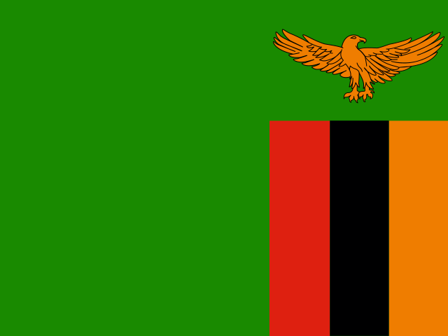
A green field carries a soaring orange eagle in the upper-right corner, above a panel of three vertical bands: red on the left, black, and orange. Green stands for the country's natural resources and vegetation; red stands for the struggle for freedom, black for the people, and orange for the country's mineral wealth. The eagle represents the people's ability to rise above the nation's problems. The national symbol is the African fish eagle.
Source: CIA World Factbook · 2026-02-01 · text generated from this source, approved by a person
CIA World Factbook
Values from the CIA World Factbook archive. Each carries the year it describes; open a year for the exact source field.
Natural Earth outlines · features with a Wikidata ID
Population · Natural Earth