Name
The name combines the first letters of "Tanganyika" and "Zanzibar", the two states that merged to form Tanzania in 1964.
Source: CIA World Factbook · 2026-02-01 · text generated from this source, approved by a person
 Tanzania
6.05° S, 34.96° E
The population grows 2.85% a year, at 33.45 per 1,000 births per 1,000 people.
population growth +2.85% · 14th/230 · birth rate 33.45 per 1,000 · 17th/226
CIA World Factbook · 2026-02-01 · ranks computed across the countries in this atlas that carry the value
geometry: Natural Earth 1:50m · EPSG:6933 equal-area
Each line is every country in this atlas that carries the value, ordered smallest to largest. The line down the middle is the world median; the mark on each line is this country.
The name combines the first letters of "Tanganyika" and "Zanzibar", the two states that merged to form Tanzania in 1964.
Source: CIA World Factbook · 2026-02-01 · text generated from this source, approved by a person
On the Indian Ocean in Eastern Africa, Tanzania lies between Kenya and Mozambique. Plains follow the coast, while a central plateau gives way to highlands in the north and south. Kilimanjaro is Tanzania's highest point and Africa's highest point. The continent's mountain ranges with glaciers include Kilimanjaro, Mount Kenya in Kenya, and the Ruwenzori Mountains on the Uganda-Democratic Republic of the Congo border.
Lake Victoria borders Tanzania in the north, Lake Tanganyika in the west, and Lake Nyasa (Lake Malawi) in the southwest. The Indian Ocean marks the country's lowest point. Natural resources include hydropower, tin, phosphates, iron ore, coal, diamonds, gemstones including tanzanite, gold, natural gas, and nickel. Tanzanite is found only in Tanzania.
Source: CIA World Factbook · 2026-02-01 · text generated from this source, approved by a person
Along the coast, the climate is tropical, while the highlands have a temperate climate. The central plateau experiences flooding during the rainy season, and drought also occurs.
Source: CIA World Factbook · 2026-02-01 · text generated from this source, approved by a person
The mainland's population is African, including Bantu peoples, while Asian, European, and Arab people also live there. Zanzibar's population includes Arab, African, and mixed Arab and African people. Kiswahili or Swahili is official, and Kiunguja is the name for Swahili in Zanzibar. English is also official and serves as the primary language of commerce, administration, and higher education. Arabic and many local languages are also spoken.
Christian, Muslim, folk religion, Buddhist, Hindu, and Jewish affiliations occur. Population distribution is extremely uneven, with greater population clusters in the northern half of the country and along the east coast.
Source: CIA World Factbook · 2026-02-01 · text generated from this source, approved by a person
The form of government is a presidential republic. Its legal system uses English common law, with judicial review of legislative acts limited to matters of interpretation. The latest constitution was adopted 25 April 1977, following several previous constitutions. Independence came on 26 April 1964, when Tanganyika united with Zanzibar to form the United Republic of Tanganyika and Zanzibar. The country was renamed United Republic of Tanzania on 29 October 1964. The national holiday is Union Day (Tanganyika and Zanzibar), observed on 26 April (1964).
Source: CIA World Factbook · 2026-02-01 · text generated from this source, approved by a person
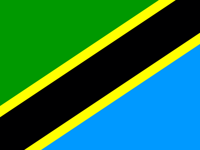
A yellow-edged black band runs from the lower left to the upper right, dividing the flag into a green upper-left triangle and a blue lower triangle. Its colors come from the flags of Tanganyika and Zanzibar. Green stands for natural vegetation, gold for rich mineral deposits, black for the Swahili people, and blue for lakes and rivers and the Indian Ocean. National symbols are the Uhuru (freedom) torch and giraffe.
Source: CIA World Factbook · 2026-02-01 · text generated from this source, approved by a person
CIA World Factbook
Values from the CIA World Factbook archive. Each carries the year it describes; open a year for the exact source field.
Natural Earth outlines · features with a Wikidata ID
Population · Natural Earth