13 cities

Location of UgandaDemocratic Republic of the CongoSouth SudanCentral African RepublicKenyaSudanBurundiEthiopiaSomalilandSomaliaRwandaTanzaniaChadUgandaMbararaBomboJinjaAruaMbaleEntebbeTororoGuluLiraKampala
Country

Uganda

1.97° N, 32.95° E

Half of everyone here is under 16 — only 2 countries in the world are younger.

median age 16.4 years · 222nd/224
CIA World Factbook · 2026-02-01 · ranks computed across the countries in this atlas that carry the value

Population
44,269,594
Area
241,038 km²
Population density
≈ 183 / km²
Capital
Kampala
Natural Earth
ISO codes
UG · UGA
GDP (nominal)
$53.65 billion
GDP per capita (PPP)
$2,900
How big, reallyDrawn at the same scale as Senegal — the next country down in size. Equal-area projection, not the map you are used to.
Uganda 241,038 km²Senegal 196,722 km²

geometry: Natural Earth 1:50m · EPSG:6933 equal-area

Where Uganda sits in the world

Each line is every country in this atlas that carries the value, ordered smallest to largest. The line down the middle is the world median; the mark on each line is this country.

  1. Median age16.4 years222nd of 224 · median 32.6 years
  2. Life expectancy69.7 years179th of 224 · median 76.2 years
  3. Fertility rate5.08 children per woman8th of 225 · median 1.92 children per woman
  4. Population44,269,59433rd of 235 · median 5,454,073
  5. Total area241,038 km²81st of 228 · median 83,736 km²
  6. Coastline0 km185th of 229 · median 402 km

Overview

People and society

Uganda's people include Baganda, Banyankole, Basoga, Bakiga, Iteso, Langi, Bagisu, Acholi, and Lugbara, alongside others. Religious affiliations include Protestant, Roman Catholic, and Muslim, with Protestant traditions including Anglican, Pentecostal/Born Again/Evangelical, Seventh Day Adventist, and Baptist.

Population density is relatively high in comparison to other African nations, and most of the population is concentrated in the central and southern parts of the country. People are particularly concentrated along the shores of Lake Victoria and Lake Albert, while the northeast is least populated.

Source: CIA World Factbook · 2026-02-01 · text generated from this source, approved by a person

Government

Its form of government is a presidential republic. Its legal system is a mixed system of English common law and customary law. The latest constitution was adopted 27 September 1995 and promulgated 8 October 1995. Independence from the UK came on 9 October 1962. The national holiday is Independence Day, 9 October (1962).

Source: CIA World Factbook · 2026-02-01 · text generated from this source, approved by a person

Flag and symbols

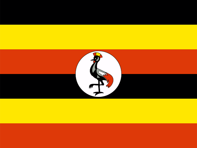
Six equal horizontal bands—black, yellow, red, black, yellow, and red—form Uganda's flag, with a white disk at the center. The disk shows a grey crowned crane, the national symbol. Black stands for the African people, yellow for sunshine and vitality, and red for African brotherhood.

Source: CIA World Factbook · 2026-02-01 · text generated from this source, approved by a person
Key figures

CIA World Factbook

Economy

GDP (nominal)
$53.65 billion
GDP (PPP)
$144.14 billion
GDP per capita (PPP)
$2,900
GDP growth
+6.1%
Inflation (consumer prices)
3.3%
Unemployment
3%
Exports
$9.08 billion
Imports
$13.85 billion

People

Life expectancy
69.7 years
Median age
16.4 years
Birth rate
38.91 per 1,000
Death rate
4.61 per 1,000
Fertility rate
5.08 children per woman
Population growth
+3.13% a year
Urban population
26.8%
Literacy
69.1%
Languages
  • Englishofficial
  • Ganda or Luganda
  • Nilo-Saharan languages
  • Swahiliofficial
  • Arabic
  • others
Religions
  • Protestant45.1%Anglican 32.0%, Pentecostal/Born Again/Evangelical 11.1%, Seventh Day Adventist 1.7%, Baptist .3%
  • Roman Catholic39.3%
  • Muslim13.7%
  • other0.2%

Land

Total area
241,038 km²Land 197,100 km² · Water 43,938 km²
Coastline
0 km
Land borders
2,729 km
Highest point
5,110 m Margherita Peak on Mount Stanley

Values from the CIA World Factbook archive. Each carries the year it describes; open a year for the exact source field.

Connections

Natural geography 7

Natural Earth outlines · features with a Wikidata ID

Mountain ranges 1

Largest cities 13

Population · Natural Earth

  1. Kampalacapital1.4M
  2. Mbale402.4K
  3. Jinja301.6K
  4. Arua250K
  5. Entebbe175.1K
  6. Tororo150K
  7. Gulu146.9K
  8. Lira135.4K
  9. Mbarara83.7K
  10. Bombo75K
  11. Kasese67.3K
  12. Masaka65.4K

Sources