19 cities

Location of MozambiqueEquatorial GuineaDemocratic Republic of the CongoeSwatiniSouth SudanCentral African RepublicKenyaGabonUgandaAngolaBurundiMauritiusSeychellesNigeriaEthiopiaSouth AfricaFranceLesothoCongoComorosBotswanaMalawiSomaliaRwandaTanzaniaMadagascarCameroonSão Tomé and PrincipeZambiaZimbabweNamibiaMozambiqueMaxixeMatolaBeiraChimoioXai-XaiNacalaQuelimaneMaputoTeteNampula
Country

Mozambique

13.94° S, 37.84° E

Life expectancy here is 58.3 years — the 221st lowest of 224 countries.

life expectancy 58.3 years · 221st/224
CIA World Factbook · 2026-02-01 · ranks computed across the countries in this atlas that carry the value

Population
30,366,036
Area
799,380 km²
Population density
≈ 39 / km²
Capital
Maputo
Natural Earth
ISO codes
MZ · MOZ
GDP (nominal)
$22.42 billion
GDP per capita (PPP)
$1,500
How big, reallyDrawn at the same scale as Myanmar — the next country down in size. Equal-area projection, not the map you are used to.
Mozambique 799,380 km²Myanmar 676,578 km²

geometry: Natural Earth 1:50m · EPSG:6933 equal-area

Where Mozambique sits in the world

Each line is every country in this atlas that carries the value, ordered smallest to largest. The line down the middle is the world median; the mark on each line is this country.

  1. Median age17.4 years216th of 224 · median 32.6 years
  2. Life expectancy58.3 years221st of 224 · median 76.2 years
  3. Fertility rate4.58 children per woman16th of 225 · median 1.92 children per woman
  4. Population30,366,03647th of 235 · median 5,454,073
  5. Total area799,380 km²36th of 228 · median 83,736 km²
  6. Coastline2,470 km49th of 229 · median 402 km

Overview

Name

Named for an offshore island, Mozambique takes its name from Mussa bin BIQUE (or Mussa Ibn Malik), an influential Arab slave trader who set himself up as sultan there in the 15th century.

Source: CIA World Factbook · 2026-02-01 · text generated from this source, approved by a person

Geography

Between South Africa and Tanzania, Mozambique borders the Mozambique Channel in southeastern Africa. Its terrain includes mostly coastal lowlands, uplands in the center, high plateaus in the northwest, and mountains in the west. The Zambezi River flows through the north-central and most fertile part of the country.

Mozambique's natural resources include coal, titanium, natural gas, hydropower, tantalum, and graphite. Monte Binga is the highest point, while the Indian Ocean is the lowest point.

Source: CIA World Factbook · 2026-02-01 · text generated from this source, approved by a person

People and society

Mozambique's people include Makhuwa, Tsonga, Lomwe, Sena, and other African groups, alongside Mestizo people and people of European, Indian, Pakistani, and Chinese backgrounds. Catholic, Islam, Pentecostal, and Saio/Zione affiliations are found alongside people with no religion, Anglican affiliations, and other or unknown affiliations.

Large population clusters lie along the southern coast between Maputo and Inhambane, and in the central area between Beira and Chimoio along the Zambezi River. Another cluster is found in and around the northern cities of Nampula, Cidade de Nacala, and Pemba. The northwest and southwest are the least populated areas.

Source: CIA World Factbook · 2026-02-01 · text generated from this source, approved by a person

Government

The form of government is a presidential republic. Its legal system is a mixed system of Portuguese civil law and customary law. The latest constitution was adopted 16 November 2004 and took effect 21 December 2004. Independence came from Portugal on 25 June 1975. Independence Day, on 25 June (1975), is the national holiday.

Source: CIA World Factbook · 2026-02-01 · text generated from this source, approved by a person

Flag and symbols

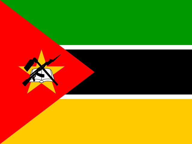
Three equal horizontal bands—green on top, black, and yellow—carry a red isosceles triangle at left. The triangle holds a five-pointed yellow star, crossed black-and-white rifle and hoe, and open white book; the black band is white-edged. Green stands for the riches of the land, white for peace, black for the African continent, yellow for the country's minerals, and red for the fight for independence. The rifle, hoe, and book are national symbols.

Source: CIA World Factbook · 2026-02-01 · text generated from this source, approved by a person
Key figures

CIA World Factbook

Economy

GDP (nominal)
$22.42 billion
GDP (PPP)
$51.79 billion
GDP per capita (PPP)
$1,500
GDP growth
+1.9%
Inflation (consumer prices)
4.1%
Unemployment
3.6%
Exports
$9.36 billion
Imports
$10.49 billion

People

Life expectancy
58.3 years
Median age
17.4 years
Birth rate
36.07 per 1,000
Death rate
9.34 per 1,000
Fertility rate
4.58 children per woman
Population growth
+2.53% a year
Urban population
38.8%
Literacy
61.7%
Religions
  • Catholic27.3%
  • Islam19.1%
  • Pentecostal16.7%
  • Saio/Zione16.3%
  • no religion13.5%
  • Anglican1.7%
  • other1.2%

Land

Total area
799,380 km²Land 786,380 km² · Water 13,000 km²
Coastline
2,470 km
Land borders
4,783 km
Mean elevation
345 m
Highest point
2,436 m Monte Binga

Values from the CIA World Factbook archive. Each carries the year it describes; open a year for the exact source field.

Connections

Natural geography 6

Natural Earth outlines · features with a Wikidata ID

Oceans 1

Largest cities 19

Population · Natural Earth

  1. Maputocapital1.4M
  2. Matola543.9K
  3. Beira530.6K
  4. Nampula388.5K
  5. Chimoio256.9K
  6. Nacala224.8K
  7. Quelimane189K
  8. Tete129.3K
  9. Xai-Xai128.8K
  10. Maxixe119.9K
  11. Inhambane115.8K
  12. Pemba110.6K

Sources