9 cities

Location of ZimbabweDemocratic Republic of the CongoeSwatiniAngolaLesothoSouth AfricaBotswanaMalawiTanzaniaMozambiqueMadagascarZambiaNamibiaZimbabweKadomaMasvingoHarareChinhoyiBulawayoChitungwizaMutareGweruKwekwe
Country

Zimbabwe

18.91° S, 29.93° E

No coast at all — every one of its 3,229 km of border is shared with another country.

coastline 0 km · 185th/229 · land borders 3,229 km · 62nd/230
CIA World Factbook · 2026-02-01 · ranks computed across the countries in this atlas that carry the value

Population
14,645,468
Area
390,757 km²
Population density
≈ 38 / km²
Capital
Harare
Natural Earth
ISO codes
ZW · ZWE
GDP (nominal)
$44.19 billion
GDP per capita (PPP)
$3,500
How big, reallyDrawn at the same scale as Côte d'Ivoire — the next country down in size. Equal-area projection, not the map you are used to.
Zimbabwe 390,757 km²Côte d'Ivoire 322,463 km²

geometry: Natural Earth 1:50m · EPSG:6933 equal-area

Where Zimbabwe sits in the world

Each line is every country in this atlas that carries the value, ordered smallest to largest. The line down the middle is the world median; the mark on each line is this country.

  1. Median age21.3 years189th of 224 · median 32.6 years
  2. Life expectancy67.2 years195th of 224 · median 76.2 years
  3. Fertility rate3.42 children per woman37th of 225 · median 1.92 children per woman
  4. Population14,645,46873rd of 235 · median 5,454,073
  5. Total area390,757 km²61st of 228 · median 83,736 km²
  6. Coastline0 km185th of 229 · median 402 km

Overview

Name

Zimbabwe takes its name from the Kingdom of Zimbabwe (13th–15th century) and its capital, Great Zimbabwe, which was built of stone. The name comes from the Bantu phrase "zimba we bahwe," meaning "houses of stones"; the former name, Rhodesia, came from British colonial administrator Cecil Rhodes.

Source: CIA World Factbook · 2026-02-01 · text generated from this source, approved by a person

People and society

Zimbabwe's population is identified as African, with Shona and Ndebele among its ethnic groups. It also includes Caucasian, Asiatic, and mixed-race people.

Religious affiliations include Apostolic Sect, Pentecostal, Protestant, other Christian, Roman Catholic, and African traditionalist traditions, as well as Muslim, Jewish, and Hindu affiliations. Outside major urban agglomerations in Harare and Bulawayo, people are distributed fairly evenly, with slightly greater overall numbers in the eastern half.

Source: CIA World Factbook · 2026-02-01 · text generated from this source, approved by a person

Government

A presidential republic governs Zimbabwe. Its legal system is a mixed system of English common law, Roman-Dutch civil law, and customary law. The current Constitution took effect on 22 May 2013, after its final draft was completed January 2013, followed by approval by referendum 16 March 2013 and by Parliament 9 May 2013. Zimbabwe gained independence from the UK on 18 April 1980. The national holiday is Independence Day, 18 April (1980).

Source: CIA World Factbook · 2026-02-01 · text generated from this source, approved by a person

Flag and symbols

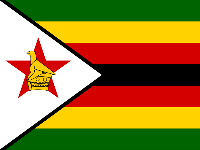
Seven equal horizontal bands—green, yellow, red, black, red, yellow, and green—accompany a white isosceles triangle edged in black on the left. A yellow bird tops a five-pointed red star in the triangle; it represents the country's long history. White stands for peace; green, agriculture; yellow, mineral wealth; red, blood shed to achieve independence; black, the people. National symbols include the Zimbabwe bird symbol, African fish eagle, and flame lily.

Source: CIA World Factbook · 2026-02-01 · text generated from this source, approved by a person
Key figures

CIA World Factbook

Economy

GDP (nominal)
$44.19 billion
GDP (PPP)
$57.39 billion
GDP per capita (PPP)
$3,500
GDP growth
+2%
Inflation (consumer prices)
104.7%
Unemployment
8.6%
Exports
$7.6 billion
Imports
$10.29 billion

People

Life expectancy
67.2 years
Median age
21.3 years
Birth rate
28.18 per 1,000
Death rate
6.4 per 1,000
Fertility rate
3.42 children per woman
Population growth
+1.82% a year
Urban population
32.5%
Literacy
93.2%
Religions
  • Apostolic Sect40.3%
  • Pentecostal17%
  • Protestant13.8%
  • Roman Catholic6.4%
  • African traditionalist5%
  • other8.3%

Land

Total area
390,757 km²Land 386,847 km² · Water 3,910 km²
Coastline
0 km
Land borders
3,229 km
Mean elevation
961 m
Highest point
2,592 m Inyangani

Values from the CIA World Factbook archive. Each carries the year it describes; open a year for the exact source field.

Connections

Natural geography 1

Natural Earth outlines · features with a Wikidata ID

Mountain ranges 1

Largest cities 9

Population · Natural Earth

  1. Hararecapital1.6M
  2. Bulawayo699.4K
  3. Chitungwiza340.4K
  4. Mutare249.4K
  5. Gweru183.4K
  6. Kwekwe99.1K
  7. Kadoma79.2K
  8. Masvingo76.3K
  9. Chinhoyi61.7K

Sources