Overview
Name
Its name describes its location on the continent, while "Africa" comes from the Roman designation "Africa terra" for the area corresponding to present-day Tunisia, meaning "Land of the Afri," the tribe resident there. The conventional long form is Republic of South Africa.
Source: CIA World Factbook · 2026-02-01 · text generated from this source, approved by a person
Background
Some of the earliest human remains were found in South Africa; by about 500 CE, Bantu-speaking groups settled northeastern South Africa.
Dutch traders founded Cape Town in 1652; after Britain seized the Cape of Good Hope in 1806, Boers trekked north to found Transvaal and Orange Free State. In the 1820s, wars began as the Zulus expanded; diamonds in 1867 and gold in 1886 spurred European immigration. After the Anglo-Zulu War in 1879, the Zulu kingdom entered the British Empire; Afrikaner republics followed after defeat in the Second South African War (1899-1902). Beginning in 1910, British and Afrikaners ruled under the Union of South Africa, which became a fully self-governing republic in 1961. In 1948, the National Party instituted apartheid, a policy of 'separate development' that favored the White minority and suppressed the Black majority and other non-White groups. The ANC led resistance; protests, insurgency, and some Western boycotts led the regime to unban it and negotiate majority rule. Multi-racial elections in 1994 brought majority rule under an ANC-led government; successive administrations addressed apartheid-era imbalances. President Cyril Ramaphosa, reelected as the ANC leader in 2022, has made some progress in reigning in corruption.
Source: CIA World Factbook · 2026-02-01 · text generated from this source, approved by a person
People and society
South Africa's ethnic groups are Black African, Colored, White, and Indian/Asian. Its official languages are isiZulu or Zulu, isiXhosa or Xhosa, Afrikaans, Sepedi or Pedi, Setswana or Tswana, and English. The official languages also include Sesotho or Sotho, Xitsonga or Tsonga, siSwati or Swati, Tshivenda or Venda, and isiNdebele or Ndebele.
Other languages include South African sign language, which is official, and Khoi or Khoisan or Khoe languages. Religious affiliations include Christian, ancestral, tribal, animist, or other traditional African religions, Muslim, other, and nothing in particular. People concentrate along the southern and southeastern coast and inland around Pretoria; the eastern half is more densely populated than the west.
Source: CIA World Factbook · 2026-02-01 · text generated from this source, approved by a person
Government
A parliamentary republic is the country’s form of government. Its legal system mixes Roman-Dutch civil law, English common law, and customary law. The latest constitution was drafted 8 May 1996, approved by the Constitutional Court 4 December 1996, and took effect 4 February 1997. Independence milestones include 31 May 1910, when the Union of South Africa formed from four British colonies; 22 August 1934, the Status of the Union Act; 31 May 1961, when the republic was declared; and 27 April 1994, majority rule. Freedom Day, 27 April (1994), is the national holiday.
Source: CIA World Factbook · 2026-02-01 · text generated from this source, approved by a person
Flag and symbols
Equal-width horizontal bands, red above blue, are separated by a central green band splitting into a horizontal Y. A black isosceles triangle in the Y has narrow yellow bands; narrow white stripes border red and blue bands. Colors have no official meaning; the Y stands for "the convergence of diverse elements within South African society, taking the road ahead in unity". National symbols are springbok (antelope) and king protea flower.
Source: CIA World Factbook · 2026-02-01 · text generated from this source, approved by a person
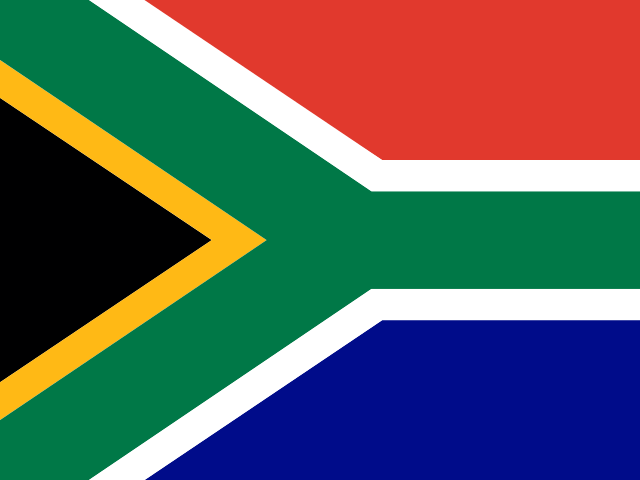 South Africa