No coast at all — every one of its 1,106 km of border is shared with another country.
coastline 0 km · 185th/229 · land borders 1,106 km · 120th/230 CIA World Factbook · 2026-02-01 · ranks computed across the countries in this atlas that carry the value
Population
2,125,268
Natural Earth population estimate.
Area
30,355 km²
Official total area (land + water) from the CIA World Factbook. Computed from the Natural Earth boundary: ≈ 29,991 km².
Field “Economy → GDP (official exchange rate)” in the CIA World Factbook archive (frozen 2026-02-01). Public domain. The Factbook stopped publishing in February 2026; the year shows when the value was estimated.
GDP per capita (PPP)
$2,600
Field “Economy → Real GDP per capita → Real GDP per capita 2024” in the CIA World Factbook archive (frozen 2026-02-01). Public domain. The Factbook stopped publishing in February 2026; the year shows when the value was estimated.
Each line is every country in this atlas that carries the value, ordered smallest to largest. The line down the middle is the world median; the mark on each line is this country.
median
Median age24 years176th of 224 · median 32.6 years
Life expectancy60.2 years218th of 224 · median 76.2 years
Fertility rate2.49 children per woman69th of 225 · median 1.92 children per woman
Population2,125,268148th of 235 · median 5,454,073
Total area30,355 km²140th of 228 · median 83,736 km²
Coastline0 km185th of 229 · median 402 km
Overview
Name
Lesotho takes its name from the Sotho people, whose name means "dark-skinned." "Le-" is a singular noun prefix, while the former name Basutoland uses the plural noun prefix "Ba-."
Source: CIA World Factbook · 2026-02-01 · text generated from this source, approved by a person
Geography
An enclave of South Africa, Lesotho lies in Southern Africa. South Africa surrounds the landlocked country. Its terrain is mostly highland, with plateaus, hills, and mountains.
Lesotho's natural resources include water, agricultural and grazing land, diamonds, sand, clay, and building stone. Thabana Ntlenyana is the country's highest point. The junction of the Orange and Makhaleng Rivers is its lowest point.
Source: CIA World Factbook · 2026-02-01 · text generated from this source, approved by a person
Climate
A temperate climate brings cool to cold, dry winters and hot, wet summers. Periodic droughts occur as a natural hazard.
Source: CIA World Factbook · 2026-02-01 · text generated from this source, approved by a person
Government
The government is a parliamentary constitutional monarchy. Its legal system combines English common law and Roman-Dutch law, while the High Court and Court of Appeal review legislative acts. The current constitution was adopted 2 April 1993, effectively restoring the 1967 version. Lesotho gained independence from the UK on 4 October 1966. Its national holiday is Independence Day, 4 October (1966).
Source: CIA World Factbook · 2026-02-01 · text generated from this source, approved by a person
Flag and symbols
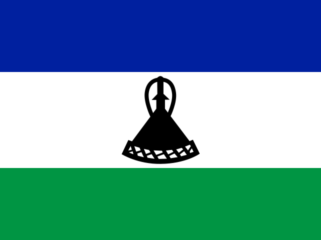
Three horizontal stripes—blue at the top, white, and green—make up the flag, with a black mokorotlo centered on the white stripe. The mokorotlo is a traditional Basotho straw hat and national symbol; blue stands for rain, white for peace, and green for prosperity. The redesigned flag was introduced in 2006 to celebrate independence. The national symbol is mokorotio (Basotho hat).
Source: CIA World Factbook · 2026-02-01 · text generated from this source, approved by a person
Key figures
CIA World Factbook
Economy
GDP (nominal)
$2.27 billion
Field “Economy → GDP (official exchange rate)” in the CIA World Factbook archive (frozen 2026-02-01). Public domain. The Factbook stopped publishing in February 2026; the year shows when the value was estimated.
GDP (PPP)
$6.17 billion
Field “Economy → Real GDP (purchasing power parity) → Real GDP (purchasing power parity) 2024” in the CIA World Factbook archive (frozen 2026-02-01). Public domain. The Factbook stopped publishing in February 2026; the year shows when the value was estimated.
GDP per capita (PPP)
$2,600
Field “Economy → Real GDP per capita → Real GDP per capita 2024” in the CIA World Factbook archive (frozen 2026-02-01). Public domain. The Factbook stopped publishing in February 2026; the year shows when the value was estimated.
GDP growth
+2.8%
Field “Economy → Real GDP growth rate → Real GDP growth rate 2024” in the CIA World Factbook archive (frozen 2026-02-01). Public domain. The Factbook stopped publishing in February 2026; the year shows when the value was estimated.
Inflation (consumer prices)
6.1%
Field “Economy → Inflation rate (consumer prices) → Inflation rate (consumer prices) 2024” in the CIA World Factbook archive (frozen 2026-02-01). Public domain. The Factbook stopped publishing in February 2026; the year shows when the value was estimated.
Unemployment
16.2%
Field “Economy → Unemployment rate → Unemployment rate 2024” in the CIA World Factbook archive (frozen 2026-02-01). Public domain. The Factbook stopped publishing in February 2026; the year shows when the value was estimated.
Exports
$983.03 million
Field “Economy → Exports → Exports 2024” in the CIA World Factbook archive (frozen 2026-02-01). Public domain. The Factbook stopped publishing in February 2026; the year shows when the value was estimated.
Imports
$2.08 billion
Field “Economy → Imports → Imports 2024” in the CIA World Factbook archive (frozen 2026-02-01). Public domain. The Factbook stopped publishing in February 2026; the year shows when the value was estimated.
People
Life expectancy
60.2 years
Field “People and Society → Life expectancy at birth → total population” in the CIA World Factbook archive (frozen 2026-02-01). Public domain. The Factbook stopped publishing in February 2026; the year shows when the value was estimated.
Median age
24 years
Field “People and Society → Median age → total” in the CIA World Factbook archive (frozen 2026-02-01). Public domain. The Factbook stopped publishing in February 2026; the year shows when the value was estimated.
Birth rate
21.68 per 1,000
Field “People and Society → Birth rate” in the CIA World Factbook archive (frozen 2026-02-01). Public domain. The Factbook stopped publishing in February 2026; the year shows when the value was estimated.
Death rate
10.2 per 1,000
Field “People and Society → Death rate” in the CIA World Factbook archive (frozen 2026-02-01). Public domain. The Factbook stopped publishing in February 2026; the year shows when the value was estimated.
Fertility rate
2.49 children per woman
Field “People and Society → Total fertility rate” in the CIA World Factbook archive (frozen 2026-02-01). Public domain. The Factbook stopped publishing in February 2026; the year shows when the value was estimated.
Population growth
+0.73% a year
Field “People and Society → Population growth rate” in the CIA World Factbook archive (frozen 2026-02-01). Public domain. The Factbook stopped publishing in February 2026; the year shows when the value was estimated.
Urban population
30.4%
Field “People and Society → Urbanization → urban population” in the CIA World Factbook archive (frozen 2026-02-01). Public domain. The Factbook stopped publishing in February 2026; the year shows when the value was estimated.
Literacy
90.4%
Field “People and Society → Literacy → total population” in the CIA World Factbook archive (frozen 2026-02-01). Public domain. The Factbook stopped publishing in February 2026; the year shows when the value was estimated.
Languages
Sesothoofficial
Englishofficial
Phuthi
Xhosa
Zulu
Field “People and Society → Languages” in the CIA World Factbook archive (frozen 2026-02-01). Public domain. The Factbook stopped publishing in February 2026; the year shows when the value was estimated.
Field “People and Society → Religions” in the CIA World Factbook archive (frozen 2026-02-01). Public domain. The Factbook stopped publishing in February 2026; the year shows when the value was estimated.
Land
Total area
30,355 km²Land 30,355 km² · Water 0 km²
Field “Geography → Area → total” in the CIA World Factbook archive (frozen 2026-02-01). Public domain. The Factbook stopped publishing in February 2026; the year shows when the value was estimated.
Coastline
0 km
Field “Geography → Coastline” in the CIA World Factbook archive (frozen 2026-02-01). Public domain. The Factbook stopped publishing in February 2026; the year shows when the value was estimated.
Land borders
1,106 km
Field “Geography → Land boundaries → total” in the CIA World Factbook archive (frozen 2026-02-01). Public domain. The Factbook stopped publishing in February 2026; the year shows when the value was estimated.
Mean elevation
2,161 m
Field “Geography → Elevation → mean elevation” in the CIA World Factbook archive (frozen 2026-02-01). Public domain. The Factbook stopped publishing in February 2026; the year shows when the value was estimated.
Highest point
3,482 m Thabana Ntlenyana
Field “Geography → Elevation → highest point” in the CIA World Factbook archive (frozen 2026-02-01). Public domain. The Factbook stopped publishing in February 2026; the year shows when the value was estimated.
Values from the CIA World Factbook archive. Each carries the year it describes; open a year for the exact source field.
 Lesotho