Name
The name derives from the Arabic "balad-as-sudan", meaning "Land of the Black [peoples]."
Source: CIA World Factbook · 2026-02-01 · text generated from this source, approved by a person
 Sudan
Sudan16.33° N, 29.26° E
The population grows 2.54% a year, at 32.95 per 1,000 births per 1,000 people.
population growth +2.54% · 17th/230 · birth rate 32.95 per 1,000 · 18th/226
CIA World Factbook · 2026-02-01 · ranks computed across the countries in this atlas that carry the value
geometry: Natural Earth 1:50m · EPSG:6933 equal-area
Each line is every country in this atlas that carries the value, ordered smallest to largest. The line down the middle is the world median; the mark on each line is this country.
The name derives from the Arabic "balad-as-sudan", meaning "Land of the Black [peoples]."
Source: CIA World Factbook · 2026-02-01 · text generated from this source, approved by a person
Sudan borders the Red Sea in north-eastern Africa, between Egypt and Eritrea. A generally flat, featureless plain characterizes Sudan, with desert dominating the north. The Red Sea is Sudan's lowest point. Jabal Marrah is Sudan's highest point.
The Nile is Sudan's primary water source, and its major tributaries, the White Nile and the Blue Nile, meet at Khartoum to form the River Nile. The River Nile flows northward through Egypt to the Mediterranean Sea. Petroleum and hydropower are natural resources, alongside small reserves of iron ore, copper, chromium ore, zinc, tungsten, mica, silver, and gold.
Source: CIA World Factbook · 2026-02-01 · text generated from this source, approved by a person
Hot, dry conditions and arid desert characterize the climate, while the rainy season varies by region. Dust storms and periodic persistent droughts are climate hazards.
Source: CIA World Factbook · 2026-02-01 · text generated from this source, approved by a person
A ribbon of settlement follows the banks of the Nile, while northern Sudan is sparsely populated beyond it. Sizeable areas of population are found around Khartoum, southeast between the Blue and White Nile Rivers, and throughout South Darfur.
Sudanese Arab, Fur, Beja, Nuba, Ingessana, Uduk, Fallata, Masalit, Dajo, Gimir, Tunjur, and Berti are among its ethnic groups. Arabic and English are official languages, alongside Nubian, Ta Bedawie, and Fur. Sunni Muslim and a small Christian minority are present.
Source: CIA World Factbook · 2026-02-01 · text generated from this source, approved by a person
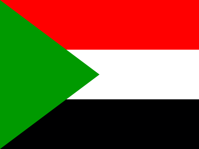
Three equal horizontal bands—red at the top, followed by white and black—form the flag, with a green isosceles triangle based on the left side. Red stands for the struggle for freedom; white for peace, light, and love; black for the people; and green for Islam, agriculture, and prosperity. The colors and design are based on the Arab Revolt flag of World War I. The secretary bird is the national symbol.
Source: CIA World Factbook · 2026-02-01 · text generated from this source, approved by a person
CIA World Factbook
Values from the CIA World Factbook archive. Each carries the year it describes; open a year for the exact source field.
Natural Earth outlines · features with a Wikidata ID
Population · Natural Earth