Field “Economy → GDP (official exchange rate)” in the CIA World Factbook archive (frozen 2026-02-01). Public domain. The Factbook stopped publishing in February 2026; the year shows when the value was estimated.
GDP per capita (PPP)
$12,300
Field “Economy → Real GDP per capita → Real GDP per capita 2024” in the CIA World Factbook archive (frozen 2026-02-01). Public domain. The Factbook stopped publishing in February 2026; the year shows when the value was estimated.
Each line is every country in this atlas that carries the value, ordered smallest to largest. The line down the middle is the world median; the mark on each line is this country.
median
Median age26.4 years163rd of 224 · median 32.6 years
Life expectancy77.7 years85th of 224 · median 76.2 years
Fertility rate2.96 children per woman47th of 225 · median 1.92 children per woman
Population6,777,452109th of 235 · median 5,454,073
Total area1,759,540 km²18th of 228 · median 83,736 km²
Coastline1,770 km63rd of 229 · median 402 km
Overview
Geography
Along the Mediterranean Sea, Libya lies in Northern Africa between Egypt, Tunisia, and Algeria. The terrain is mostly barren, consisting of flat to undulating plains, plateaus, and depressions. Libya's geography includes desert and semidesert. South central Libya contains Waw an Namus, a volcano in the middle of the Sahara. Its caldera is an oasis; the name means 'oasis of mosquitoes.' Several small lakes in the caldera host many species of insects and birds.
Libya's natural resources include petroleum, natural gas, and gypsum. Bikku Bitti is the highest point, while Sabkhat Ghuzayyil is the lowest point.
Source: CIA World Factbook · 2026-02-01 · text generated from this source, approved by a person
Climate
Mediterranean conditions along Libya’s coast give way to a dry, extreme desert interior. The hot, dry, dust-laden ghibli is a southern wind in spring and fall, alongside dust storms and sandstorms.
Source: CIA World Factbook · 2026-02-01 · text generated from this source, approved by a person
Government
Government is in transition. Libya's post-revolution legal system is in flux and driven by state and non-state entities. The constitutional history lists previous constitutions from 1951 and 1977, and an interim one from 2011. Independence came on 24 December 1951 from UN trusteeship. Liberation Day, 23 October (2011), is the national holiday.
Source: CIA World Factbook · 2026-02-01 · text generated from this source, approved by a person
Flag and symbols
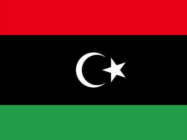
Red, black, and green horizontal bands, with black double-width, carry a white crescent and star centered on the black stripe, representing Islam. The colors represent the country's three major regions: red stands for Fezzan, black for Cyrenaica, and green for Tripolitania. In 2011, the National Transitional Council reintroduced this design from the former Kingdom of Libya, replacing the QADHAFI regime's all-green banner. The national symbols are the star and crescent and hawk.
Source: CIA World Factbook · 2026-02-01 · text generated from this source, approved by a person
Key figures
CIA World Factbook
Economy
GDP (nominal)
$46.64 billion
Field “Economy → GDP (official exchange rate)” in the CIA World Factbook archive (frozen 2026-02-01). Public domain. The Factbook stopped publishing in February 2026; the year shows when the value was estimated.
GDP (PPP)
$90.61 billion
Field “Economy → Real GDP (purchasing power parity) → Real GDP (purchasing power parity) 2024” in the CIA World Factbook archive (frozen 2026-02-01). Public domain. The Factbook stopped publishing in February 2026; the year shows when the value was estimated.
GDP per capita (PPP)
$12,300
Field “Economy → Real GDP per capita → Real GDP per capita 2024” in the CIA World Factbook archive (frozen 2026-02-01). Public domain. The Factbook stopped publishing in February 2026; the year shows when the value was estimated.
GDP growth
-0.6%
Field “Economy → Real GDP growth rate → Real GDP growth rate 2024” in the CIA World Factbook archive (frozen 2026-02-01). Public domain. The Factbook stopped publishing in February 2026; the year shows when the value was estimated.
Inflation (consumer prices)
2.1%
Field “Economy → Inflation rate (consumer prices) → Inflation rate (consumer prices) 2024” in the CIA World Factbook archive (frozen 2026-02-01). Public domain. The Factbook stopped publishing in February 2026; the year shows when the value was estimated.
Unemployment
18.7%
Field “Economy → Unemployment rate → Unemployment rate 2024” in the CIA World Factbook archive (frozen 2026-02-01). Public domain. The Factbook stopped publishing in February 2026; the year shows when the value was estimated.
Exports
$37.75 billion
Field “Economy → Exports → Exports 2023” in the CIA World Factbook archive (frozen 2026-02-01). Public domain. The Factbook stopped publishing in February 2026; the year shows when the value was estimated.
Imports
$33.28 billion
Field “Economy → Imports → Imports 2023” in the CIA World Factbook archive (frozen 2026-02-01). Public domain. The Factbook stopped publishing in February 2026; the year shows when the value was estimated.
People
Life expectancy
77.7 years
Field “People and Society → Life expectancy at birth → total population” in the CIA World Factbook archive (frozen 2026-02-01). Public domain. The Factbook stopped publishing in February 2026; the year shows when the value was estimated.
Median age
26.4 years
Field “People and Society → Median age → total” in the CIA World Factbook archive (frozen 2026-02-01). Public domain. The Factbook stopped publishing in February 2026; the year shows when the value was estimated.
Birth rate
19.83 per 1,000
Field “People and Society → Birth rate” in the CIA World Factbook archive (frozen 2026-02-01). Public domain. The Factbook stopped publishing in February 2026; the year shows when the value was estimated.
Death rate
3.48 per 1,000
Field “People and Society → Death rate” in the CIA World Factbook archive (frozen 2026-02-01). Public domain. The Factbook stopped publishing in February 2026; the year shows when the value was estimated.
Fertility rate
2.96 children per woman
Field “People and Society → Total fertility rate” in the CIA World Factbook archive (frozen 2026-02-01). Public domain. The Factbook stopped publishing in February 2026; the year shows when the value was estimated.
Population growth
+1.35% a year
Field “People and Society → Population growth rate” in the CIA World Factbook archive (frozen 2026-02-01). Public domain. The Factbook stopped publishing in February 2026; the year shows when the value was estimated.
Urban population
81.6%
Field “People and Society → Urbanization → urban population” in the CIA World Factbook archive (frozen 2026-02-01). Public domain. The Factbook stopped publishing in February 2026; the year shows when the value was estimated.
Languages
Arabicofficial
Italian
English
Tamazight
Field “People and Society → Languages → Languages” in the CIA World Factbook archive (frozen 2026-02-01). Public domain. The Factbook stopped publishing in February 2026; the year shows when the value was estimated.
Land
Total area
1,759,540 km²Land 1,759,540 km² · Water 0 km²
Field “Geography → Area → total” in the CIA World Factbook archive (frozen 2026-02-01). Public domain. The Factbook stopped publishing in February 2026; the year shows when the value was estimated.
Coastline
1,770 km
Field “Geography → Coastline” in the CIA World Factbook archive (frozen 2026-02-01). Public domain. The Factbook stopped publishing in February 2026; the year shows when the value was estimated.
Land borders
4,339 km
Field “Geography → Land boundaries → total” in the CIA World Factbook archive (frozen 2026-02-01). Public domain. The Factbook stopped publishing in February 2026; the year shows when the value was estimated.
Mean elevation
423 m
Field “Geography → Elevation → mean elevation” in the CIA World Factbook archive (frozen 2026-02-01). Public domain. The Factbook stopped publishing in February 2026; the year shows when the value was estimated.
Highest point
2,267 m Bikku Bitti
Field “Geography → Elevation → highest point” in the CIA World Factbook archive (frozen 2026-02-01). Public domain. The Factbook stopped publishing in February 2026; the year shows when the value was estimated.
Values from the CIA World Factbook archive. Each carries the year it describes; open a year for the exact source field.
 Libya
Libya