3 cities

Location of North MacedoniaItalyBosnia and HerzegovinaGreeceKosovoTürkiyeBulgariaAlbaniaCroatiaRomaniaSerbiaMontenegroNorth MacedoniaBitolaTetovoSkopje
Country

North Macedonia

41.56° N, 21.56° E

No coast at all — every one of its 838 km of border is shared with another country.

coastline 0 km · 185th/229 · land borders 838 km · 126th/230
CIA World Factbook · 2026-02-01 · ranks computed across the countries in this atlas that carry the value

Population
2,083,459
Area
25,713 km²
Population density
≈ 82 / km²
Capital
Skopje
Natural Earth
ISO codes
MK · MKD
GDP (nominal)
$16.69 billion
GDP per capita (PPP)
$24,500
How big, reallyDrawn at the same scale as El Salvador — the next country down in size. Equal-area projection, not the map you are used to.
North Macedonia 25,713 km²El Salvador 21,041 km²

geometry: Natural Earth 1:50m · EPSG:6933 equal-area

Where North Macedonia sits in the world

Each line is every country in this atlas that carries the value, ordered smallest to largest. The line down the middle is the world median; the mark on each line is this country.

  1. Median age40.9 years57th of 224 · median 32.6 years
  2. Life expectancy77.3 years91st of 224 · median 76.2 years
  3. Fertility rate1.53 children per woman177th of 225 · median 1.92 children per woman
  4. Population2,083,459150th of 235 · median 5,454,073
  5. Total area25,713 km²148th of 228 · median 83,736 km²
  6. Coastline0 km185th of 229 · median 402 km

Overview

Name

The name derives from the ancient kingdom of Macedon, whose own name origin is unclear. It may derive from the mythological Macedon, son of the Greek god Zeus, or from the Greek word "makednos," meaning "tail," or the Illyrian word "maketia," meaning "cattle".

Source: CIA World Factbook · 2026-02-01 · text generated from this source, approved by a person

Geography

North of Greece, the country lies in Southeastern Europe. Mountainous terrain has deep basins and valleys, and the Vardar River bisects the country. Three large lakes are each divided by a frontier line.

The country's natural resources include low-grade iron ore, copper, lead, zinc, chromite, manganese, nickel, tungsten, gold, silver, asbestos, gypsum, timber, and arable land. The landlocked country is a major transportation corridor from Western and Central Europe to Aegean Sea and Southern Europe to Western Europe. Golem Korab (Maja e Korabit) is the country's highest point. The Vardar River is the country's lowest point.

Source: CIA World Factbook · 2026-02-01 · text generated from this source, approved by a person

Climate

Warm, dry summers and autumns give way to relatively cold winters with heavy snowfall.

Source: CIA World Factbook · 2026-02-01 · text generated from this source, approved by a person

People and society

Macedonian, Albanian, Turkish, Romani, and Serb people live in North Macedonia, alongside others. Macedonian and Albanian are official languages, alongside Turkish, Romani, and other languages including Aromanian (Vlach) and Bosnian.

Orthodox, Islam, and Christian affiliations are present, alongside other affiliations including atheist, Catholic, other religions, not specified, and Protestant. People are fairly evenly distributed throughout most of the country, while urban areas attract larger and denser populations.

Source: CIA World Factbook · 2026-02-01 · text generated from this source, approved by a person

Flag and symbols

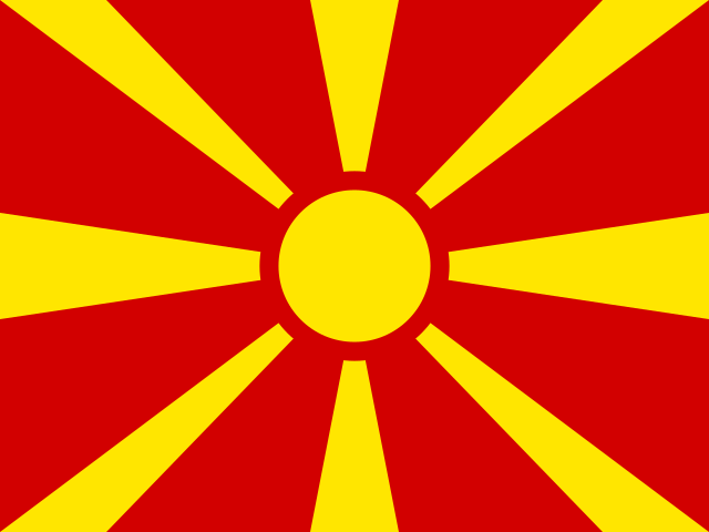
A red field has a yellow sun, the Sun of Liberty, at its center, with eight broadening rays extending to the edges. The red and yellow colors have long been associated with Macedonia. The national symbol is an eight-rayed sun.

Source: CIA World Factbook · 2026-02-01 · text generated from this source, approved by a person
Key figures

CIA World Factbook

Economy

GDP (nominal)
$16.69 billion
GDP (PPP)
$43.84 billion
GDP per capita (PPP)
$24,500
GDP growth
+2.8%
Inflation (consumer prices)
3.5%
Unemployment
13.5%
Exports
$10.45 billion
Imports
$12.64 billion

People

Life expectancy
77.3 years
Median age
40.9 years
Birth rate
10.07 per 1,000
Death rate
9.62 per 1,000
Fertility rate
1.53 children per woman
Population growth
+0.08% a year
Urban population
59.5%
Languages
  • Macedonianofficial61.4%
  • Albanianofficial24.3%
  • Turkish3.4%
  • Romani1.7%
  • others7.2%

Land

Total area
25,713 km²Land 25,433 km² · Water 280 km²
Coastline
0 km
Land borders
838 km
Mean elevation
741 m
Highest point
2,764 m Golem Korab (Maja e Korabit)

Values from the CIA World Factbook archive. Each carries the year it describes; open a year for the exact source field.

Connections

Natural geography 1

Natural Earth outlines · features with a Wikidata ID

Peninsulas 1

Largest cities 3

Population · Natural Earth

  1. Skopjecapital494.1K
  2. Tetovo119.1K
  3. Bitola86.5K

Sources