Name
The name probably derives from Uruk, called "Erech" in Aramaic, the ancient Sumerian and Babylonian city on the Euphrates River.
Source: CIA World Factbook · 2026-02-01 · text generated from this source, approved by a person
 Iraq
Iraq33.09° N, 43.26° E
3,809 km of land border against just 58 km of coast — this country faces its neighbors far more than it faces the sea.
coastline 58 km · 171st/229 · land borders 3,809 km · 54th/230
CIA World Factbook · 2026-02-01 · ranks computed across the countries in this atlas that carry the value
geometry: Natural Earth 1:50m · EPSG:6933 equal-area
Each line is every country in this atlas that carries the value, ordered smallest to largest. The line down the middle is the world median; the mark on each line is this country.
The name probably derives from Uruk, called "Erech" in Aramaic, the ancient Sumerian and Babylonian city on the Euphrates River.
Source: CIA World Factbook · 2026-02-01 · text generated from this source, approved by a person
At the head of the Persian Gulf, Iraq occupies a strategic location on the Shatt al Arab waterway. In the Middle East, it borders the Persian Gulf and lies between Iran and Kuwait. The terrain consists mostly of broad plains, with reedy marshes and large flooded areas along the Iranian border in the south.
Mountains line its borders with Iran and Türkiye. Cheekha Dar, Kurdish for 'Black Tent,' is the country's highest point. Its natural resources include petroleum, natural gas, phosphates, and sulfur. The Persian Gulf is the country's lowest point.
Source: CIA World Factbook · 2026-02-01 · text generated from this source, approved by a person
Its people include Arab and Kurdish communities, along with Turkmen, Yezidi, Shabak, Kaka'i, Bedouin, Romani, Assyrian, Circassian, Sabaean-Mandaean, and Persian communities. Arabic and Kurdish are official languages; Turkmen, a Turkish dialect, and Syriac, or Neo-Aramaic, are recognized as official where native speakers are present.
Muslim is the official religion, with Shia and Sunni communities; Christians include Catholic, Orthodox, Protestant, and Assyrian Church of the East traditions. People are concentrated in the north, center, and eastern parts of Iraq, with many larger urban agglomerations along extensive parts of the Tigris and Euphrates Rivers. Western and southern areas are either lightly populated or uninhabited.
Source: CIA World Factbook · 2026-02-01 · text generated from this source, approved by a person
A federal parliamentary republic is Iraq's form of government. Its legal system is a mixed system of civil and Islamic law. After several previous constitutions, the current one was adopted by referendum 15 October 2005. Iraq gained independence 3 October 1932 from League of Nations mandate under British administration. Its national holidays are Independence Day, 3 October (1932), and Republic Day, 14 July (1958).
Source: CIA World Factbook · 2026-02-01 · text generated from this source, approved by a person
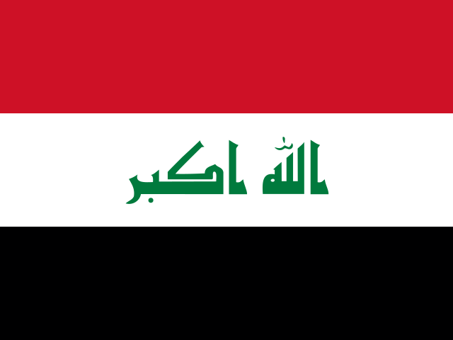
Three equal horizontal bands of red at the top, white, and black carry the Takbir, an Arabic phrase meaning "God is great," in green Arabic script centered in the white band. The colors come from the Arab Liberation flag and stand for oppression in black overcome through bloody struggle in red, to be replaced by a bright future in white. The Council of Representatives approved this flag in 2008 as a compromise replacement for the Ba'thist SADDAM-era flag. Iraq's national symbol is the golden eagle.
Source: CIA World Factbook · 2026-02-01 · text generated from this source, approved by a person
CIA World Factbook
Values from the CIA World Factbook archive. Each carries the year it describes; open a year for the exact source field.
Natural Earth outlines · features with a Wikidata ID
Population · Natural Earth