Name
The name may derive from the Surinen people, who inhabited the area at the time of European contact.
Source: CIA World Factbook · 2026-02-01 · text generated from this source, approved by a person
 Suriname
4.14° N, 55.91° W
1,907 km of land border against just 386 km of coast — this country faces its neighbors far more than it faces the sea.
coastline 386 km · 118th/229 · land borders 1,907 km · 91st/230
CIA World Factbook · 2026-02-01 · ranks computed across the countries in this atlas that carry the value
geometry: Natural Earth 1:50m · EPSG:6933 equal-area
Each line is every country in this atlas that carries the value, ordered smallest to largest. The line down the middle is the world median; the mark on each line is this country.
The name may derive from the Surinen people, who inhabited the area at the time of European contact.
Source: CIA World Factbook · 2026-02-01 · text generated from this source, approved by a person
Spaniards first explored Suriname in the 16th century, and the English settled it in the mid-17th century. Suriname became a Dutch colony in 1667, and with the abolition of African slavery in 1863, workers were brought in from India and Java. The Netherlands granted the colony independence in 1975.
The civilian government was later replaced by a military regime, which soon declared Suriname a socialist republic. The regime continued to exert control through a succession of nominally civilian administrations until 1987, when international pressure forced a democratic election. In 1990, the military overthrew the civilian leadership, but a democratically elected government, a four-party coalition, returned to power in 1991. The coalition expanded to eight parties in 2005 and ruled until 2010, when voters returned former military leader Desire Bouterse and his opposition coalition to power. President Bouterse ran unopposed in 2015 and was reelected. Opposition parties campaigned hard against Bouterse before the 2020 elections, and a multi-party coalition led by Chandrikapersad Santokhi’s VHP and Ronnie Brunswijk’s ABOP was installed.
Source: CIA World Factbook · 2026-02-01 · text generated from this source, approved by a person
Suriname occupies northern South America, bordering the North Atlantic Ocean between French Guiana and Guyana. Its terrain consists mostly of rolling hills and a narrow coastal plain with swamps. The country is the smallest independent country on the South American continent. The country is mostly tropical rainforest, with great diversity of flora and fauna and a relatively small population mostly along the coast.
Timber, hydropower, fish, kaolin, shrimp, bauxite, and gold are among its natural resources. It also has small amounts of nickel, copper, platinum, and iron ore. Juliana Top is the country's highest point. The lowest point is an unnamed location in the coastal plain.
Source: CIA World Factbook · 2026-02-01 · text generated from this source, approved by a person
Along the northern coastal strip, Suriname's population is concentrated, while the country's interior is sparsely populated. Hindustani, also known locally as East Indians, Maroon, Creole, Javanese, mixed people, and others live in Suriname. Hindustani ancestors emigrated from northern India, while Maroon ancestors were brought from Africa and escaped to the interior. Creole people are mixed White and Black.
Dutch is the official language; English is widely spoken, alongside Sranang Tongo, Caribbean Hindustani, and Javanese. Sranang Tongo, sometimes called Taki-Taki, is the native language of Creoles and much of the younger population. Religions include Protestant, Hindu, Roman Catholic, Muslim, other Christian, Winti, and Jehovah's Witnesses.
Source: CIA World Factbook · 2026-02-01 · text generated from this source, approved by a person
A presidential republic governs Suriname. Its legal system is a civil law system influenced by Dutch civil law. The latest constitution was ratified 30 September 1987 and took effect 30 October 1987. Suriname gained independence on 25 November 1975 from the Netherlands. The national holiday is Independence Day, 25 November (1975).
Source: CIA World Factbook · 2026-02-01 · text generated from this source, approved by a person
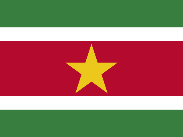
Five horizontal bands run from top to bottom: green (double-width), white, red (quadruple-width), white, and green (double-width), with a five-pointed yellow star centered on the red band. Red stands for progress and love, green for hope and fertility, and white for peace, justice, and freedom. The star represents the unity of ethnic groups. The national symbols are the royal palm and faya lobi (flower).
Source: CIA World Factbook · 2026-02-01 · text generated from this source, approved by a person
CIA World Factbook
Values from the CIA World Factbook archive. Each carries the year it describes; open a year for the exact source field.
Natural Earth outlines · features with a Wikidata ID
Population · Natural Earth