Overview
Background
The only English-speaking country in South America, Guyana shares cultural and historical bonds with the Anglophone Caribbean. Originally a Dutch colony in the 17th century, it had become a British possession by 1815. The abolition of slavery led former slaves to settle urban areas, while indentured servants were imported from India to work sugar plantations. This resulting ethnocultural divide persisted and led to turbulent politics. Guyana achieved independence from the UK in 1966, and primarily socialist-oriented governments ruled the country thereafter.
In 1992, Cheddi Jagan was elected president in what is considered the country's first free and fair election since independence. Janet Jagan became president and resigned in 1999 due to poor health. Bharrat Jagdeo succeeded her, winning election in 2001 and again in 2006. Donald Ramotar won in 2011, but early elections held in 2015 produced the first change in governing party, bringing David Granger to office. After a 2018 no-confidence vote against the Granger government, the administration ignored a constitutional requirement to hold elections and remained in place until the 2020 elections. Irfaan Ali became president in the 2020 elections. The discovery of massive offshore oil reserves in 2015 has been Guyana's primary economic and political focus, with many hoping the reserves will transform the country.
Source: CIA World Factbook · 2026-02-01 · text generated from this source, approved by a person
Geography
On the northern edge of South America, Guyana borders the North Atlantic Ocean between Suriname and Venezuela. The terrain combines mostly rolling highlands with a low coastal plain and savanna in the south.
Guyana contains some of the largest unspoiled rainforests on the continent. Among its natural resources are bauxite, gold, diamonds, hardwood timber, shrimp, and fish. Laberintos del Norte on Mount Roraima marks the country's highest point. The Atlantic Ocean is the country's lowest point.
Source: CIA World Factbook · 2026-02-01 · text generated from this source, approved by a person
People and society
In and around Georgetown, the population is heavily concentrated in the northeast, with notable concentrations along the Berbice River to the east. The remainder of the country is sparsely populated. Ethnic communities include East Indian, African descent, mixed, and Indigenous people, as well as others.
Protestant affiliations include Pentecostal, Seventh Day Adventist, Anglican, and Methodist. People also identify as Hindu, other Christian, Roman Catholic, Muslim, Jehovah's Witness, Rastafarian, and others, or with no religion.
Source: CIA World Factbook · 2026-02-01 · text generated from this source, approved by a person
Government
A parliamentary republic governs Guyana. Its legal system uses a common law system, based on the English model, with some Roman-Dutch civil law influence. The latest constitution was promulgated 6 October 1980. Guyana gained independence from the UK on 26 May 1966, and its national holiday is Republic Day, 23 February (1970).
Source: CIA World Factbook · 2026-02-01 · text generated from this source, approved by a person
Flag and symbols
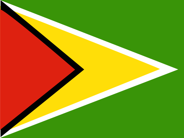
A green flag carries a red isosceles triangle based on the left side, over a long yellow arrowhead shape extending to the opposite side. A narrow black border sits between the red and yellow, while a narrow white border sits between the yellow and green. Green stands for forest and foliage, yellow for mineral resources and a bright future, white for the rivers, red for zeal and the people's sacrifice, and black for perseverance. The national symbols are Canje pheasant (hoatzin), jaguar, and Victoria Regia water lily.
Source: CIA World Factbook · 2026-02-01 · text generated from this source, approved by a person
 Guyana