49 cities

Location of SpainItalyMaltaGuernseyVaticanNorth MacedoniaGreeceSwedenCentral African RepublicGermanyBosnia and HerzegovinaWestern SaharaUnited KingdomKosovoNorwayIsle of ManMoldovaSudanBurkina FasoMaliSenegalLibyaJerseyAndorraFranceSan MarinoMonacoCabo VerdeEgyptNigeriaTürkiyeBelarusMontenegroAustriaLuxembourgSwitzerlandBulgariaDenmarkNetherlandsLatviaLithuaniaAlbaniaSlovakiaCroatiaSloveniaGambiaGuinea-BissauBelgiumPortugalUkraineAlgeriaPolandMoroccoLiechtensteinCameroonNigerRomaniaChadGuineaTunisiaIrelandMauritaniaCzechiaHungarySerbiaSpainMadridSevilleBilbaoGranadaBarcelonaValenciaZaragozaMalagaMurciaVigo
CountryTranscontinental

Spain

40.09° N, 3.46° W

4,964 km of coast against 1,953 km of land border — this country faces the sea far more than it faces its neighbors.

coastline 4,964 km · 28th/229 · land borders 1,953 km · 90th/230
CIA World Factbook · 2026-02-01 · ranks computed across the countries in this atlas that carry the value

Population
47,076,781
Area
505,370 km²
Population density
≈ 93 / km²
Capital
Madrid
Natural Earth
ISO codes
ES · ESP
GDP (nominal)
$1.72 trillion
GDP per capita (PPP)
$48,400
How big, reallyDrawn at the same scale as Paraguay — the next country down in size. Equal-area projection, not the map you are used to.
Spain 505,370 km²Paraguay 406,752 km²

geometry: Natural Earth 1:50m · EPSG:6933 equal-area

Where Spain sits in the world

Each line is every country in this atlas that carries the value, ordered smallest to largest. The line down the middle is the world median; the mark on each line is this country.

  1. Median age47.2 years8th of 224 · median 32.6 years
  2. Life expectancy83 years17th of 224 · median 76.2 years
  3. Fertility rate1.32 children per woman205th of 225 · median 1.92 children per woman
  4. Population47,076,78130th of 235 · median 5,454,073
  5. Total area505,370 km²53rd of 228 · median 83,736 km²
  6. Coastline4,964 km28th of 229 · median 402 km

Overview

Geography

Spain lies in southwestern Europe, bordering the Mediterranean Sea, North Atlantic Ocean, Bay of Biscay, and Pyrenees Mountains, southwest of France. Its large, flat to dissected plateau is surrounded by rugged hills, with the Pyrenees Mountains in the north. Natural resources include coal, iron ore, copper, lead, zinc, uranium, tungsten, mercury, gypsum, potash, hydropower, and arable land.

Its location along approaches to Strait of Gibraltar is strategic. Spain controls territories in northern Morocco, including the enclaves of Ceuta and Melilla and the islands of Penon de Velez de la Gomera, Penon de Alhucemas, and Islas Chafarinas. The Canary Islands form part of Macaronesia, alongside the Azores and Madeira in Portugal and Cabo Verde. Pico de Teide on Tenerife in the Canary Islands is the highest point. The Atlantic Ocean is the lowest point.

Source: CIA World Factbook · 2026-02-01 · text generated from this source, approved by a person

People and society

Spain’s ethnic groups include Spanish, Moroccan, Romanian, and others. Castilian Spanish is official, while Catalan is official in Catalonia, the Balearic Islands, and the Valencian Community. Galician is official in Galicia, Basque in the Basque Country and Navarre, and Aranese in part of Catalonia.

Religious affiliations include Roman Catholic, atheist, agnostic, non-believer, other, and unspecified affiliations. Except for Madrid, Sevilla, and Zaragoza, the largest urban agglomerations lie along the Mediterranean and Atlantic coasts. Numerous smaller cities spread through the interior, while settlement is very dense around Madrid, the capital, and Barcelona, the port city.

Source: CIA World Factbook · 2026-02-01 · text generated from this source, approved by a person

Government

Spain has a parliamentary constitutional monarchy. Its legal system is a civil law system with regional variations. The latest constitution took effect on 29 December 1978, after approval by the General Courts on 31 October 1978, passage by referendum on 6 December 1978, and signing by the king on 27 December 1978. National Day (Hispanic Day) falls on 12 October.

Source: CIA World Factbook · 2026-02-01 · text generated from this source, approved by a person

Flag and symbols

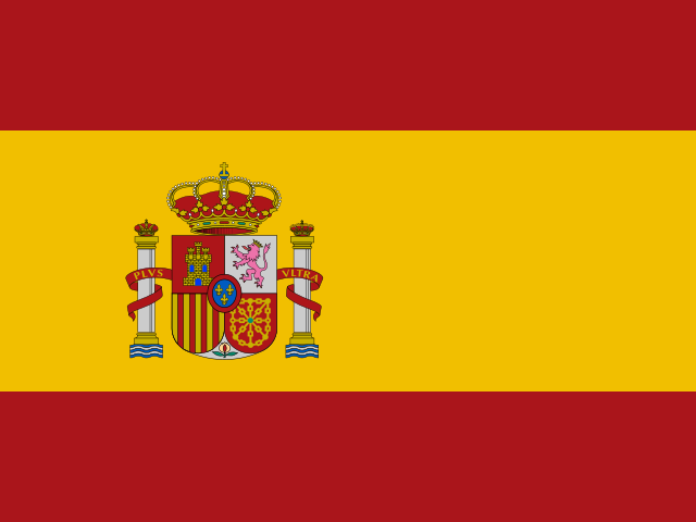
Three horizontal bands—red, yellow at double width, and red—carry a coat of arms at yellow’s left. The shield bears emblems of Castile, Leon, Navarre, and Aragon; a stylized pomegranate represents Granada. Two columns represent the Pillars of Hercules, promontories Gibraltar and Ceuta on the Strait of Gibraltar. A red scroll bears the imperial motto "Plus Ultra" ("further beyond"). The national symbol is the Pillars of Hercules.

Source: CIA World Factbook · 2026-02-01 · text generated from this source, approved by a person
Key figures

CIA World Factbook

Economy

GDP (nominal)
$1.72 trillion
GDP (PPP)
$2.36 trillion
GDP per capita (PPP)
$48,400
GDP growth
+3.2%
Inflation (consumer prices)
2.8%
Unemployment
11.4%
Exports
$642.36 billion
Imports
$568.5 billion

People

Life expectancy
83 years
Median age
47.2 years
Birth rate
7.16 per 1,000
Death rate
9.98 per 1,000
Fertility rate
1.32 children per woman
Population growth
+0.12% a year
Urban population
81.6%
Literacy
99.7%
Religions
  • Roman Catholic58.2%
  • atheist16.2%
  • agnostic10.8%
  • non-believer10.5%
  • other1.7%

Land

Total area
505,370 km²Land 498,980 km² · Water 6,390 km²
Coastline
4,964 km
Land borders
1,953 km
Mean elevation
660 m
Highest point
3,718 m Pico de Teide (Tenerife) on Canary Islands

Values from the CIA World Factbook archive. Each carries the year it describes; open a year for the exact source field.

Connections

Natural geography 23

Natural Earth outlines · features with a Wikidata ID

Largest cities 49

Population · Natural Earth

  1. Madridcapital5.6M
  2. Barcelona4.9M
  3. Seville1.2M
  4. Bilbao875.6K
  5. Valencia808K
  6. Zaragoza649.4K
  7. Malaga550.1K
  8. Murcia406.8K
  9. Granada388.3K
  10. Vigo379K
  11. Las Palmas378.5K
  12. Palma375.8K

Sources