Name
Explorer Christopher Columbus named the island in 1493 after Saint Martin of Tours because he visited on 11 November, the saint's feast day.
Source: CIA World Factbook · 2026-02-01 · text generated from this source, approved by a person
 Sint Maarten
18.04° N, 63.07° W
100% of everyone here lives in a city.
urban population 100% · 1st/225
CIA World Factbook · 2026-02-01 · ranks computed across the countries in this atlas that carry the value
geometry: Natural Earth 1:50m · EPSG:6933 equal-area
Each line is every country in this atlas that carries the value, ordered smallest to largest. The line down the middle is the world median; the mark on each line is this country.
Explorer Christopher Columbus named the island in 1493 after Saint Martin of Tours because he visited on 11 November, the saint's feast day.
Source: CIA World Factbook · 2026-02-01 · text generated from this source, approved by a person
Salt drew the Dutch to Saint Martin in 1631, after Christopher Columbus claimed it for Spain in 1493 and named it for the feast day of St. Martin of Tours. The Spanish retook Saint Martin in 1633, but the Dutch continued to assert their claims. Spain finally relinquished the island to the French and Dutch, who divided it in 1648. Friction between the two countries made the border fluctuate for 200 years, with the Dutch eventually holding the smaller portion and using Sint Maarten, the Dutch spelling, for their territory. The establishment of cotton, tobacco, and sugar plantations dramatically expanded African slavery on the island in the 18th and 19th centuries. The practice was not abolished in the Dutch half until 1863.
The island's economy declined until 1939, when it became a free port, and tourism expanded dramatically beginning in the 1950s. In 1954, Sint Maarten and several other Dutch Caribbean possessions became part of the Kingdom of the Netherlands as the Netherlands Antilles. In a 2000 referendum, Sint Maarten's citizens voted to become a self-governing country within the Kingdom of the Netherlands, effective in 2010. In 2017, Hurricane Irma hit Saint Martin and Sint Maarten, causing extensive damage to roads, communications, electrical power, and housing.
Source: CIA World Factbook · 2026-02-01 · text generated from this source, approved by a person
The northern border is shared with the French overseas collectivity of Saint Martin. Together, these two entities make up the smallest landmass in the world shared by two self-governing states. Sint Maarten lies in the Caribbean, in the northern group of the Leeward Islands, and east of the US Virgin Islands.
Sint Maarten has low, hilly terrain of volcanic origin. Simpson Bay Lagoon, also called Simson Bay Lagoon or The Great Pond, is shared by the French and Dutch halves of Saint Martin, with their border running across its center. Fish and salt are natural resources of Sint Maarten. The highest point lies southwest of Mount Flagstaff summit. The lowest point is at the Caribbean Sea.
Source: CIA World Factbook · 2026-02-01 · text generated from this source, approved by a person
Ethnic backgrounds include Saint Maarten, Dominican Republic, Haiti, Jamaica, Saint Martin, Guyana, Dominica, and Curaçao. Other backgrounds include Aruba, Saint Kitts and Nevis, India, the Netherlands, the US, Suriname, Saint Lucia, and Anguilla.
Protestant affiliations include Pentecostal, Methodist, Seventh Day Adventist, Baptist, Anglican, and other Protestant churches. Roman Catholic, Hindu, Christian, Jehovah's Witness, Evangelical, Muslim, and Jewish affiliations also appear, alongside Buddhist, Sikh, and Rastafarian traditions. The most populous areas are Lower Prince's Quarter, north of Philipsburg, and Cul de Sac.
Source: CIA World Factbook · 2026-02-01 · text generated from this source, approved by a person
Its government is a parliamentary democracy under a constitutional monarchy. The legal system is based on Dutch civil law system with some English common law influence. The current constitution was adopted 21 July 2010 and entered into force 10 October 2010; it regulates governance of Sint Maarten but is subordinate to the Charter for the Kingdom of the Netherlands. Sint Maarten has no independence and is part of the Kingdom of the Netherlands. The national holiday is King's Day, the birthday of King Willem-Alexander.
Source: CIA World Factbook · 2026-02-01 · text generated from this source, approved by a person
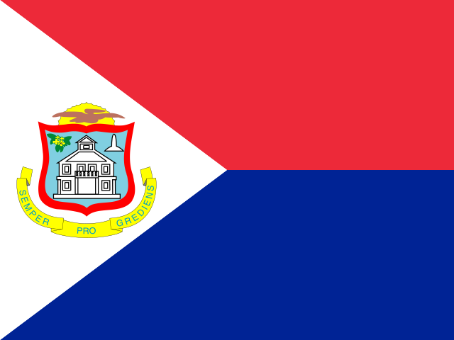
Equal horizontal red-blue bands carry a white isosceles triangle based on the left side and center the coat of arms. An orange-bordered blue shield shows Philipsburg's white courthouse, yellow sage at upper left, and a Dutch-French friendship monument silhouette at upper right. Above it are a yellow rising sun and brown pelican in flight; below, a yellow scroll bears "SEMPER PROGREDIENS (Always Progressing)." National symbols are the brown pelican and yellow sage, the national flower.
Source: CIA World Factbook · 2026-02-01 · text generated from this source, approved by a person
CIA World Factbook
Values from the CIA World Factbook archive. Each carries the year it describes; open a year for the exact source field.
Natural Earth outlines · features with a Wikidata ID