Overview
Background
Indian Ocean trade long supported the inhabitants of the area that is now Oman. In the late 18th century, the nascent sultanate in Muscat signed the first in a series of friendship treaties with Britain. Although dependence on British political and military advisors increased, the sultanate never became a British colony. In 1970, Qaboos bin Said Al Said overthrew his father, became sultan, and ruled until his death in 2020. His extensive modernization program opened Oman to the outside world, while he prioritized strategic ties to the UK and US. His moderate, independent foreign policy allowed Oman to maintain good relations with its neighbors and avoid external entanglements.
In 2011, popular uprisings that swept the Middle East and North Africa inspired demonstrations in Oman calling for more jobs, economic benefits, and an end to corruption. Qaboos responded with reforms, granting Oman’s legislative body more power and authorizing direct elections for its lower house. He also increased unemployment benefits and issued a royal directive mandating a national public- and private-sector job creation plan. To decentralize authority and allow greater citizen participation in local governance, Oman conducted its first municipal council elections in 2012. Qaboos, Oman’s longest reigning monarch, died in 2020, and his cousin, Haytham bin Tariq Al Said, was sworn in as the new sultan the same day.
Source: CIA World Factbook · 2026-02-01 · text generated from this source, approved by a person
Geography
Between Yemen and the UAE, Oman borders the Arabian Sea, Gulf of Oman, and Persian Gulf in the Middle East. Its terrain includes a central desert plain and rugged mountains in the north and south. Oman consists of Oman proper and the northern exclaves Musandam and Al Madhah. Musandam is a peninsula occupying a strategic location adjacent to the Strait of Hormuz.
Its natural resources include petroleum, copper, asbestos, some marble, limestone, chromium, gypsum, and natural gas. Jabal Shams is the highest point. The Arabian Sea is the lowest point.
Source: CIA World Factbook · 2026-02-01 · text generated from this source, approved by a person
People and society
Oman’s people include Arab, Baluchi, South Asian (Indian, Pakistani, Sri Lankan, Bangladeshi), and African communities. Arabic is the official language, while English, Baluchi, Swahili, Urdu, and Indian dialects are also spoken.
People in Oman identify as Muslim, Christian, Hindu, or other and unaffiliated. The population clusters in and around the Al Hagar Mountains in the north, with another, smaller cluster around Salalah in the far south. Most of the country remains sparsely populated.
Source: CIA World Factbook · 2026-02-01 · text generated from this source, approved by a person
Government
An absolute monarchy governs the country. Its legal system is a mixed system of Anglo-Saxon law and Islamic law. The Basic Law of the Sultanate of Oman serves as the constitution, promulgated by royal decree 6 November 1996 and amended by royal decree in 2011. Independence in 1650 marks the expulsion of the Portuguese. National Day is 18 November.
Source: CIA World Factbook · 2026-02-01 · text generated from this source, approved by a person
Flag and symbols
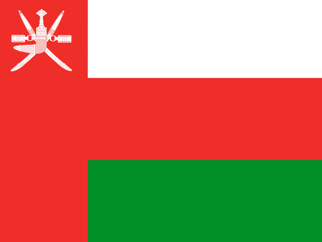
Three equal horizontal bands—white at the top, red, and green—with a vertical red band on the left carry a white national emblem centered near its top. White stands for peace and prosperity, red for battles against foreign invaders, and green for the Jebel al Akhdar (Green Mountains) and fertility. The national symbol is a khanjar dagger on top of two crossed swords.
Source: CIA World Factbook · 2026-02-01 · text generated from this source, approved by a person
 Oman
Oman