1,448 km of coast against 490 km of land border — this country faces the sea far more than it faces its neighbors.
coastline 1,448 km · 69th/229 · land borders 490 km · 142nd/230 CIA World Factbook · 2026-02-01 · ranks computed across the countries in this atlas that carry the value
Population
4,941,444
Natural Earth population estimate.
Area
70,273 km²
Official total area (land + water) from the CIA World Factbook. Computed from the Natural Earth boundary: ≈ 68,981 km².
Field “Economy → GDP (official exchange rate)” in the CIA World Factbook archive (frozen 2026-02-01). Public domain. The Factbook stopped publishing in February 2026; the year shows when the value was estimated.
GDP per capita (PPP)
$115,300
Field “Economy → Real GDP per capita → Real GDP per capita 2024” in the CIA World Factbook archive (frozen 2026-02-01). Public domain. The Factbook stopped publishing in February 2026; the year shows when the value was estimated.
Each line is every country in this atlas that carries the value, ordered smallest to largest. The line down the middle is the world median; the mark on each line is this country.
median
Median age40.5 years61st of 224 · median 32.6 years
Life expectancy82 years36th of 224 · median 76.2 years
Fertility rate1.72 children per woman145th of 225 · median 1.92 children per woman
Population4,941,444124th of 235 · median 5,454,073
Total area70,273 km²120th of 228 · median 83,736 km²
Coastline1,448 km69th of 229 · median 402 km
Overview
Government
A parliamentary republic is Ireland's form of government. Its common law system is based on the English model but substantially modified by customary law, and the Supreme Court reviews legislative acts. The current constitution was drafted 14 June 1937, adopted by plebiscite 1 July 1937, and took effect 29 December 1937. Independence dates are 6 December 1921 (from the UK), 6 December 1922 (Irish Free State established), and 18 April 1949 (Republic of Ireland Act enabled). Ireland's national holiday is Saint Patrick's Day, 17 March.
Source: CIA World Factbook · 2026-02-01 · text generated from this source, approved by a person
Flag and symbols
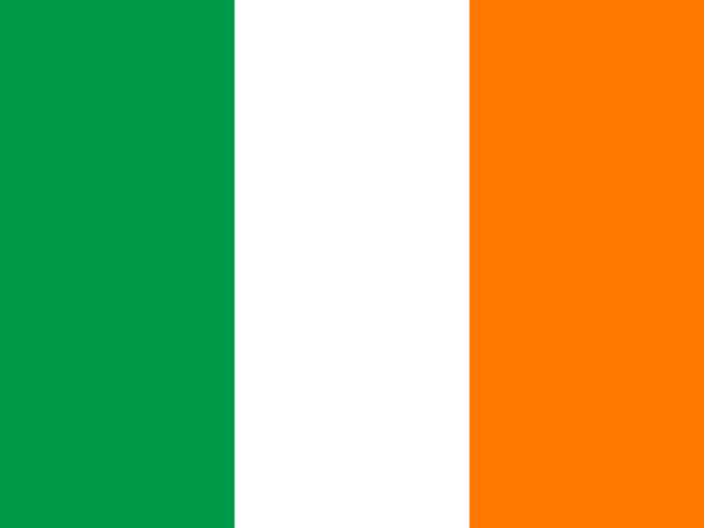
Three equal vertical bands of green on the left side, white, and orange form the flag. The colors have no official meaning. A common interpretation assigns green to the Irish nationalist tradition and orange to the Orange tradition, meaning minority supporters of William of Orange. It assigns white to peace or a lasting truce between the green and the orange. The national symbols are the harp and shamrock (trefoil).
Source: CIA World Factbook · 2026-02-01 · text generated from this source, approved by a person
Key figures
CIA World Factbook
Economy
GDP (nominal)
$577.39 billion
Field “Economy → GDP (official exchange rate)” in the CIA World Factbook archive (frozen 2026-02-01). Public domain. The Factbook stopped publishing in February 2026; the year shows when the value was estimated.
GDP (PPP)
$620.54 billion
Field “Economy → Real GDP (purchasing power parity) → Real GDP (purchasing power parity) 2024” in the CIA World Factbook archive (frozen 2026-02-01). Public domain. The Factbook stopped publishing in February 2026; the year shows when the value was estimated.
GDP per capita (PPP)
$115,300
Field “Economy → Real GDP per capita → Real GDP per capita 2024” in the CIA World Factbook archive (frozen 2026-02-01). Public domain. The Factbook stopped publishing in February 2026; the year shows when the value was estimated.
GDP growth
+1.2%
Field “Economy → Real GDP growth rate → Real GDP growth rate 2024” in the CIA World Factbook archive (frozen 2026-02-01). Public domain. The Factbook stopped publishing in February 2026; the year shows when the value was estimated.
Inflation (consumer prices)
2.1%
Field “Economy → Inflation rate (consumer prices) → Inflation rate (consumer prices) 2024” in the CIA World Factbook archive (frozen 2026-02-01). Public domain. The Factbook stopped publishing in February 2026; the year shows when the value was estimated.
Unemployment
4.4%
Field “Economy → Unemployment rate → Unemployment rate 2024” in the CIA World Factbook archive (frozen 2026-02-01). Public domain. The Factbook stopped publishing in February 2026; the year shows when the value was estimated.
Exports
$761.88 billion
Field “Economy → Exports → Exports 2023” in the CIA World Factbook archive (frozen 2026-02-01). Public domain. The Factbook stopped publishing in February 2026; the year shows when the value was estimated.
Imports
$580.4 billion
Field “Economy → Imports → Imports 2023” in the CIA World Factbook archive (frozen 2026-02-01). Public domain. The Factbook stopped publishing in February 2026; the year shows when the value was estimated.
People
Life expectancy
82 years
Field “People and Society → Life expectancy at birth → total population” in the CIA World Factbook archive (frozen 2026-02-01). Public domain. The Factbook stopped publishing in February 2026; the year shows when the value was estimated.
Median age
40.5 years
Field “People and Society → Median age → total” in the CIA World Factbook archive (frozen 2026-02-01). Public domain. The Factbook stopped publishing in February 2026; the year shows when the value was estimated.
Birth rate
10.95 per 1,000
Field “People and Society → Birth rate” in the CIA World Factbook archive (frozen 2026-02-01). Public domain. The Factbook stopped publishing in February 2026; the year shows when the value was estimated.
Death rate
7.43 per 1,000
Field “People and Society → Death rate” in the CIA World Factbook archive (frozen 2026-02-01). Public domain. The Factbook stopped publishing in February 2026; the year shows when the value was estimated.
Fertility rate
1.72 children per woman
Field “People and Society → Total fertility rate” in the CIA World Factbook archive (frozen 2026-02-01). Public domain. The Factbook stopped publishing in February 2026; the year shows when the value was estimated.
Population growth
+0.8% a year
Field “People and Society → Population growth rate” in the CIA World Factbook archive (frozen 2026-02-01). Public domain. The Factbook stopped publishing in February 2026; the year shows when the value was estimated.
Urban population
64.5%
Field “People and Society → Urbanization → urban population” in the CIA World Factbook archive (frozen 2026-02-01). Public domain. The Factbook stopped publishing in February 2026; the year shows when the value was estimated.
Languages
Englishofficial
Irishofficial
Field “People and Society → Languages” in the CIA World Factbook archive (frozen 2026-02-01). Public domain. The Factbook stopped publishing in February 2026; the year shows when the value was estimated.
Religions
Roman Catholic69.2%includes lapsed
Protestant3.7%Church of Ireland/England/Anglican/Episcopalian 2.5%, other Protestant 1.2%
Orthodox2%
Muslim1.6%
agnostic/atheist0.1%
other6.7%
Field “People and Society → Religions” in the CIA World Factbook archive (frozen 2026-02-01). Public domain. The Factbook stopped publishing in February 2026; the year shows when the value was estimated.
Land
Total area
70,273 km²Land 68,883 km² · Water 1,390 km²
Field “Geography → Area → total” in the CIA World Factbook archive (frozen 2026-02-01). Public domain. The Factbook stopped publishing in February 2026; the year shows when the value was estimated.
Coastline
1,448 km
Field “Geography → Coastline” in the CIA World Factbook archive (frozen 2026-02-01). Public domain. The Factbook stopped publishing in February 2026; the year shows when the value was estimated.
Land borders
490 km
Field “Geography → Land boundaries → total” in the CIA World Factbook archive (frozen 2026-02-01). Public domain. The Factbook stopped publishing in February 2026; the year shows when the value was estimated.
Mean elevation
118 m
Field “Geography → Elevation → mean elevation” in the CIA World Factbook archive (frozen 2026-02-01). Public domain. The Factbook stopped publishing in February 2026; the year shows when the value was estimated.
Highest point
1,041 m Carrauntoohil
Field “Geography → Elevation → highest point” in the CIA World Factbook archive (frozen 2026-02-01). Public domain. The Factbook stopped publishing in February 2026; the year shows when the value was estimated.
Values from the CIA World Factbook archive. Each carries the year it describes; open a year for the exact source field.
 Ireland