Name
The name Haiti derives from the Arawak name "Ayti," meaning "Land of Mountains." The name originally applied to the entire island of Hispaniola.
Source: CIA World Factbook · 2026-02-01 · text generated from this source, approved by a person
 Haiti
Haiti19.26° N, 72.22° W
1,771 km of coast against 376 km of land border — this country faces the sea far more than it faces its neighbors.
coastline 1,771 km · 62nd/229 · land borders 376 km · 145th/230
CIA World Factbook · 2026-02-01 · ranks computed across the countries in this atlas that carry the value
geometry: Natural Earth 1:50m · EPSG:6933 equal-area
Each line is every country in this atlas that carries the value, ordered smallest to largest. The line down the middle is the world median; the mark on each line is this country.
The name Haiti derives from the Arawak name "Ayti," meaning "Land of Mountains." The name originally applied to the entire island of Hispaniola.
Source: CIA World Factbook · 2026-02-01 · text generated from this source, approved by a person
Most mountainous nation in the Caribbean, Haiti occupies the western part of Hispaniola, which it shares with the Dominican Republic. It lies between the Caribbean Sea and the North Atlantic Ocean, west of the Dominican Republic.
Its terrain is mostly rough and mountainous. Pic la Selle is the country's highest point. The Caribbean Sea is its lowest point. Its natural resources include bauxite, copper, calcium carbonate, gold, marble, hydropower, and arable land.
Source: CIA World Factbook · 2026-02-01 · text generated from this source, approved by a person
Tropical conditions prevail, with semiarid areas where mountains in the east cut off the trade winds. Haiti lies in the middle of the hurricane belt and is subject to severe storms from June to October, occasional flooding, and periodic droughts.
Source: CIA World Factbook · 2026-02-01 · text generated from this source, approved by a person
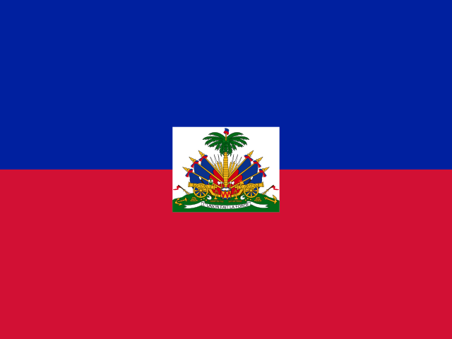
Two equal horizontal bands—blue above red—carry a centered white rectangle with the coat of arms: a palm tree flanked by flags and two cannons above a scroll. The scroll bears the motto "L'UNION FAIT LA FORCE," meaning "Union Makes Strength." The colors are taken from the French flag and represent the union of ethnic groups. The national symbols are the Hispaniolan trogon, a bird, and the hibiscus flower.
Source: CIA World Factbook · 2026-02-01 · text generated from this source, approved by a person
CIA World Factbook
Values from the CIA World Factbook archive. Each carries the year it describes; open a year for the exact source field.
Natural Earth outlines · features with a Wikidata ID
Population · Natural Earth