Santo DomingoSantiagoSan Pedro de MacorisLa Romana
Country
Dominican Republic
19.10° N, 70.65° W
1,288 km of coast against 376 km of land border — this country faces the sea far more than it faces its neighbors.
coastline 1,288 km · 74th/229 · land borders 376 km · 145th/230 CIA World Factbook · 2026-02-01 · ranks computed across the countries in this atlas that carry the value
Population
10,738,958
Natural Earth population estimate.
Area
48,670 km²
Official total area (land + water) from the CIA World Factbook. Computed from the Natural Earth boundary: ≈ 48,440 km².
Field “Economy → GDP (official exchange rate)” in the CIA World Factbook archive (frozen 2026-02-01). Public domain. The Factbook stopped publishing in February 2026; the year shows when the value was estimated.
GDP per capita (PPP)
$24,200
Field “Economy → Real GDP per capita → Real GDP per capita 2024” in the CIA World Factbook archive (frozen 2026-02-01). Public domain. The Factbook stopped publishing in February 2026; the year shows when the value was estimated.
Each line is every country in this atlas that carries the value, ordered smallest to largest. The line down the middle is the world median; the mark on each line is this country.
median
Median age29.6 years138th of 224 · median 32.6 years
Life expectancy72.6 years157th of 224 · median 76.2 years
Fertility rate2.17 children per woman84th of 225 · median 1.92 children per woman
Population10,738,95884th of 235 · median 5,454,073
Total area48,670 km²130th of 228 · median 83,736 km²
Coastline1,288 km74th of 229 · median 402 km
Overview
Name
Meaning "holy Sunday," the name is a Latinized form of the Spanish term "Santo Domingo." Spanish explorers settled the island on a Sunday in 1496, and the name was first given to Hispaniola as a whole in 1697.
Source: CIA World Factbook · 2026-02-01 · text generated from this source, approved by a person
Geography
The Dominican Republic occupies the eastern part of Hispaniola, between the Caribbean Sea and the North Atlantic Ocean, east of Haiti. Rugged highlands and mountains alternate with fertile valleys.
Its natural resources include nickel, bauxite, gold, silver, and arable land. Pico Duarte is the Caribbean's tallest mountain, while Lago Enriquillo has the Caribbean's lowest elevation and is its largest lake.
Source: CIA World Factbook · 2026-02-01 · text generated from this source, approved by a person
Flag and symbols
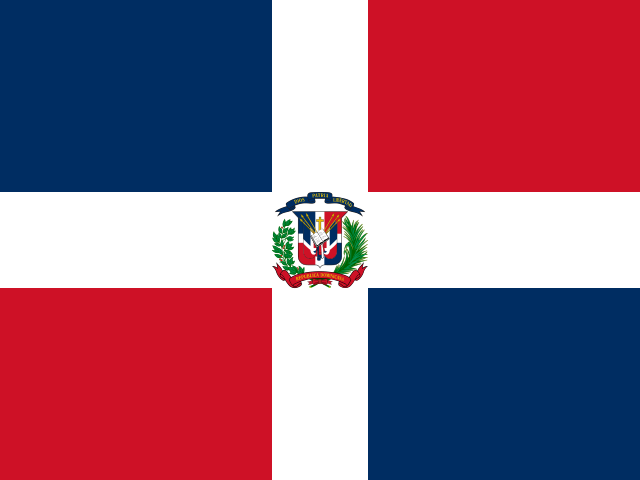
A centered white cross extends to the flag’s edges and divides it into four rectangles, with ultramarine blue at upper left, vermilion red at upper right, vermilion red at lower left, and ultramarine blue at lower right. At the center of the cross, a small coat of arms has a shield supported by a laurel branch and a palm branch. Above the shield, a blue ribbon displays the motto "DIOS, PATRIA, LIBERTAD" (God, Fatherland, Liberty), while a red ribbon below reads "REPUBLICA DOMINICANA". An open Bible on the shield is opened to a verse that reads "Y la verdad nos hara libre" (And the truth shall set you free). Blue stands for liberty, white for salvation, and red for the blood of heroes. The national symbol is the palmchat, a bird.
Source: CIA World Factbook · 2026-02-01 · text generated from this source, approved by a person
Key figures
CIA World Factbook
Economy
GDP (nominal)
$124.28 billion
Field “Economy → GDP (official exchange rate)” in the CIA World Factbook archive (frozen 2026-02-01). Public domain. The Factbook stopped publishing in February 2026; the year shows when the value was estimated.
GDP (PPP)
$276.88 billion
Field “Economy → Real GDP (purchasing power parity) → Real GDP (purchasing power parity) 2024” in the CIA World Factbook archive (frozen 2026-02-01). Public domain. The Factbook stopped publishing in February 2026; the year shows when the value was estimated.
GDP per capita (PPP)
$24,200
Field “Economy → Real GDP per capita → Real GDP per capita 2024” in the CIA World Factbook archive (frozen 2026-02-01). Public domain. The Factbook stopped publishing in February 2026; the year shows when the value was estimated.
GDP growth
+5%
Field “Economy → Real GDP growth rate → Real GDP growth rate 2024” in the CIA World Factbook archive (frozen 2026-02-01). Public domain. The Factbook stopped publishing in February 2026; the year shows when the value was estimated.
Inflation (consumer prices)
3.3%
Field “Economy → Inflation rate (consumer prices) → Inflation rate (consumer prices) 2024” in the CIA World Factbook archive (frozen 2026-02-01). Public domain. The Factbook stopped publishing in February 2026; the year shows when the value was estimated.
Unemployment
5.5%
Field “Economy → Unemployment rate → Unemployment rate 2024” in the CIA World Factbook archive (frozen 2026-02-01). Public domain. The Factbook stopped publishing in February 2026; the year shows when the value was estimated.
Exports
$28.56 billion
Field “Economy → Exports → Exports 2024” in the CIA World Factbook archive (frozen 2026-02-01). Public domain. The Factbook stopped publishing in February 2026; the year shows when the value was estimated.
Imports
$36.14 billion
Field “Economy → Imports → Imports 2024” in the CIA World Factbook archive (frozen 2026-02-01). Public domain. The Factbook stopped publishing in February 2026; the year shows when the value was estimated.
People
Life expectancy
72.6 years
Field “People and Society → Life expectancy at birth → total population” in the CIA World Factbook archive (frozen 2026-02-01). Public domain. The Factbook stopped publishing in February 2026; the year shows when the value was estimated.
Median age
29.6 years
Field “People and Society → Median age → total” in the CIA World Factbook archive (frozen 2026-02-01). Public domain. The Factbook stopped publishing in February 2026; the year shows when the value was estimated.
Birth rate
17.4 per 1,000
Field “People and Society → Birth rate” in the CIA World Factbook archive (frozen 2026-02-01). Public domain. The Factbook stopped publishing in February 2026; the year shows when the value was estimated.
Death rate
6.97 per 1,000
Field “People and Society → Death rate” in the CIA World Factbook archive (frozen 2026-02-01). Public domain. The Factbook stopped publishing in February 2026; the year shows when the value was estimated.
Fertility rate
2.17 children per woman
Field “People and Society → Total fertility rate” in the CIA World Factbook archive (frozen 2026-02-01). Public domain. The Factbook stopped publishing in February 2026; the year shows when the value was estimated.
Population growth
+0.78% a year
Field “People and Society → Population growth rate” in the CIA World Factbook archive (frozen 2026-02-01). Public domain. The Factbook stopped publishing in February 2026; the year shows when the value was estimated.
Urban population
84.4%
Field “People and Society → Urbanization → urban population” in the CIA World Factbook archive (frozen 2026-02-01). Public domain. The Factbook stopped publishing in February 2026; the year shows when the value was estimated.
Literacy
94%
Field “People and Society → Literacy → total population” in the CIA World Factbook archive (frozen 2026-02-01). Public domain. The Factbook stopped publishing in February 2026; the year shows when the value was estimated.
Languages
Spanishofficial
Field “People and Society → Languages → Languages” in the CIA World Factbook archive (frozen 2026-02-01). Public domain. The Factbook stopped publishing in February 2026; the year shows when the value was estimated.
Religions
Evangelical50.2%
Roman Catholic30.1%
other1.2%
Field “People and Society → Religions” in the CIA World Factbook archive (frozen 2026-02-01). Public domain. The Factbook stopped publishing in February 2026; the year shows when the value was estimated.
Land
Total area
48,670 km²Land 48,320 km² · Water 350 km²
Field “Geography → Area → total” in the CIA World Factbook archive (frozen 2026-02-01). Public domain. The Factbook stopped publishing in February 2026; the year shows when the value was estimated.
Coastline
1,288 km
Field “Geography → Coastline” in the CIA World Factbook archive (frozen 2026-02-01). Public domain. The Factbook stopped publishing in February 2026; the year shows when the value was estimated.
Land borders
376 km
Field “Geography → Land boundaries → total” in the CIA World Factbook archive (frozen 2026-02-01). Public domain. The Factbook stopped publishing in February 2026; the year shows when the value was estimated.
Mean elevation
424 m
Field “Geography → Elevation → mean elevation” in the CIA World Factbook archive (frozen 2026-02-01). Public domain. The Factbook stopped publishing in February 2026; the year shows when the value was estimated.
Highest point
3,098 m Pico Duarte
Field “Geography → Elevation → highest point” in the CIA World Factbook archive (frozen 2026-02-01). Public domain. The Factbook stopped publishing in February 2026; the year shows when the value was estimated.
Values from the CIA World Factbook archive. Each carries the year it describes; open a year for the exact source field.
 Dominican Republic