Overview
Background
After declaring independence from the Ottoman Empire in 1912, Albania entered a period of political upheaval. The upheaval led to a short-lived monarchy, which ended in 1939 when Italy conquered the country. Germany occupied Albania in 1943, and communist partisans took over the country in 1944. Albania allied itself first with the USSR until 1960 and then with China until 1978.
In the early 1990s, Albania ended communist rule and established a multiparty democracy. Government-endorsed pyramid schemes in 1997 led to economic collapse and civil disorder, which ended only when UN peacekeeping troops intervened. In 1999, ethnic Albanians fled from Kosovo to Albania to escape the war with the Serbs. Albania joined NATO in 2009 and became an official candidate for EU membership in 2014.
Source: CIA World Factbook · 2026-02-01 · text generated from this source, approved by a person
Geography
Albania lies in Southeastern Europe, between Greece to the south and Montenegro and Kosovo to the north, bordering the Adriatic Sea and Ionian Sea. Its strategic location along Strait of Otranto links the Adriatic Sea to the Ionian Sea and Mediterranean Sea. The terrain is mostly mountains and hills, with small plains along the coast.
Natural resources include petroleum, natural gas, coal, bauxite, chromite, copper, iron ore, nickel, salt, timber, hydropower, and arable land. Maja e Korabit (Golem Korab) is Albania's highest point, while the Adriatic Sea marks its lowest point.
Source: CIA World Factbook · 2026-02-01 · text generated from this source, approved by a person
Climate
Cool, cloudy, wet winters give way to hot, clear, dry summers in a mild temperate climate. In the interior, conditions are cooler and wetter. Floods and drought are natural hazards.
Source: CIA World Factbook · 2026-02-01 · text generated from this source, approved by a person
People and society
The country's ethnic groups include Albanian, Greek, and other groups including Vlach, Romani, Macedonian, Montenegrin, and Egyptian people. Albanian, derived from the Tosk dialect, is the official language; Greek, Macedonian, Romani, Vlach, Turkish, Italian, and Serbo-Croatian are also languages.
Religious affiliations include Muslim, Roman Catholic, Orthodox, atheist, Bektashi—a Sufi order—and other affiliations. People are fairly evenly distributed, with somewhat higher concentrations of people in the western and central parts of the country.
Source: CIA World Factbook · 2026-02-01 · text generated from this source, approved by a person
Flag and symbols
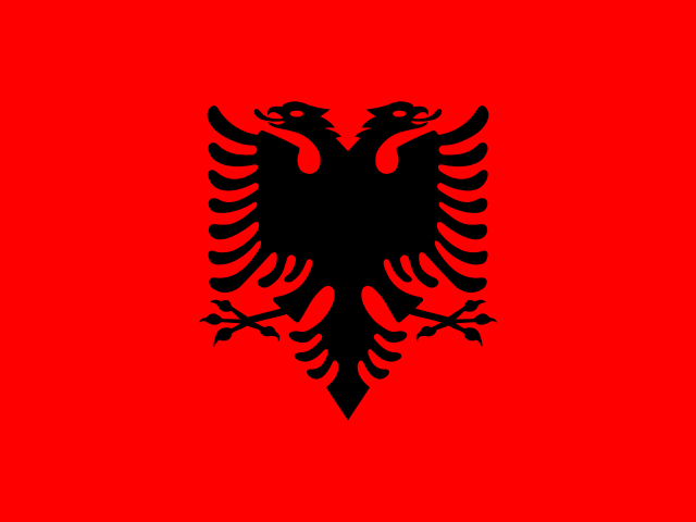
Red with a black two-headed eagle in the center, the flag depicts the eagle Albanians traditionally see themselves as descendants of. They refer to themselves as "Shqiptare," meaning "sons of the eagle." The design is said to originate with 15th-century Albanian hero Georgi Kastrioti Skanderbeg, who led a successful uprising against the Ottoman Turks. The national symbol is the black double-headed eagle.
Source: CIA World Factbook · 2026-02-01 · text generated from this source, approved by a person
 Albania