1 city

Location of Saint Kitts and NevisNetherlandsMontserratSaint Kitts and NevisBasseterre
Country

Saint Kitts and Nevis

17.34° N, 62.76° W

No land border at all — every neighbor is across water, along 135 km of coast, the 150th longest on Earth.

land borders 0 km · 164th/230 · coastline 135 km · 150th/229
CIA World Factbook · 2026-02-01 · ranks computed across the countries in this atlas that carry the value

Population
52,834
Area
261 km²
Population density
≈ 228 / km²
Capital
Basseterre
Natural Earth
ISO codes
KN · KNA
GDP (nominal)
$1.07 billion
GDP per capita (PPP)
$31,300
How big, reallyDrawn at the same scale as Aruba — the next country down in size. Equal-area projection, not the map you are used to.
Saint Kitts and Nevis 261 km²Aruba 180 km²

geometry: Natural Earth 1:50m · EPSG:6933 equal-area

Where Saint Kitts and Nevis sits in the world

Each line is every country in this atlas that carries the value, ordered smallest to largest. The line down the middle is the world median; the mark on each line is this country.

  1. Median age39.1 years71st of 224 · median 32.6 years
  2. Life expectancy77.6 years87th of 224 · median 76.2 years
  3. Fertility rate1.76 children per woman138th of 225 · median 1.92 children per woman
  4. Population52,834210th of 235 · median 5,454,073
  5. Total area261 km²204th of 228 · median 83,736 km²
  6. Coastline135 km150th of 229 · median 402 km

Overview

Background

Carib Indians occupied the islands before British and French settlers began arriving in 1623. During the 17th century, Saint Kitts became a base for British and French expansion into the Caribbean. The French ceded the territory to the UK in 1713. At the turn of the 18th century, the sugar trade brought wealth to Saint Kitts, then a British Crown Colony.

Saint Kitts and Nevis were viewed and governed as different states until the late-19th century. The British forcibly unified them with Anguilla in the late-19th century. In 1967, Saint Christopher-Nevis-Anguilla became an associated state of the UK with full internal autonomy. Anguilla rebelled and was allowed to secede in 1971. Saint Kitts and Nevis achieved independence in 1983. In 1998, a referendum on Nevis to separate from Saint Kitts fell short of the necessary majority.

Source: CIA World Factbook · 2026-02-01 · text generated from this source, approved by a person

Flag and symbols

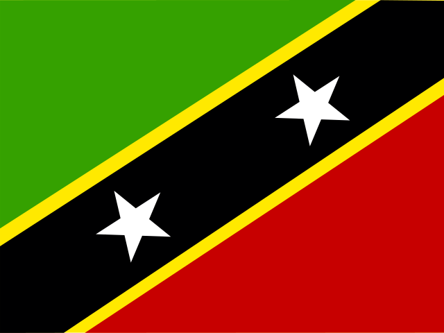
Divided diagonally from lower left, the flag has a broad black band edged in yellow, with two five-pointed white stars; the upper triangle is green and the lower is red. Green stands for island's fertility; red, people's struggles from slavery; yellow, year-round sunshine; black, the people's African heritage; white stars stand for the islands of Saint Kitts and Nevis. The brown pelican and royal poinciana (flamboyant) tree are national symbols.

Source: CIA World Factbook · 2026-02-01 · text generated from this source, approved by a person

Key figures

CIA World Factbook

Economy

GDP (nominal)
$1.07 billion
GDP (PPP)
$1.47 billion
GDP per capita (PPP)
$31,300
GDP growth
+1.2%
Inflation (consumer prices)
3.6%
Exports
$504.39 million
Imports
$642.93 million

People

Life expectancy
77.6 years
Median age
39.1 years
Birth rate
11.58 per 1,000
Death rate
7.43 per 1,000
Fertility rate
1.76 children per woman
Population growth
+0.53% a year
Urban population
31.1%
Languages
  • Englishofficial

Land

Total area
261 km²Land 261 km² · Water 0 km²
Coastline
135 km
Land borders
0 km
Highest point
1,156 m Mount Liamuiga

Values from the CIA World Factbook archive. Each carries the year it describes; open a year for the exact source field.

Connections

Natural geography 1

Natural Earth outlines · features with a Wikidata ID

Largest cities 1

Population · Natural Earth

  1. Basseterrecapital21.9K

Sources