No land border at all — every neighbor is across water, along 158 km of coast, the 147th longest on Earth.
land borders 0 km · 164th/230 · coastline 158 km · 147th/229 CIA World Factbook · 2026-02-01 · ranks computed across the countries in this atlas that carry the value
Population
182,790
Natural Earth population estimate.
Area
616 km²
Official total area (land + water) from the CIA World Factbook. Computed from the Natural Earth boundary: ≈ 549 km².
Field “Economy → GDP (official exchange rate)” in the CIA World Factbook archive (frozen 2026-02-01). Public domain. The Factbook stopped publishing in February 2026; the year shows when the value was estimated.
GDP per capita (PPP)
$24,300
Field “Economy → Real GDP per capita → Real GDP per capita 2024” in the CIA World Factbook archive (frozen 2026-02-01). Public domain. The Factbook stopped publishing in February 2026; the year shows when the value was estimated.
Each line is every country in this atlas that carries the value, ordered smallest to largest. The line down the middle is the world median; the mark on each line is this country.
median
Median age40.4 years62nd of 224 · median 32.6 years
Life expectancy79.4 years63rd of 224 · median 76.2 years
Fertility rate1.71 children per woman147th of 225 · median 1.92 children per woman
Population182,790187th of 235 · median 5,454,073
Total area616 km²188th of 228 · median 83,736 km²
Coastline158 km147th of 229 · median 402 km
Overview
Name
French sailors who were shipwrecked on the island on 13 December 1502, the saint's feast day, are believed to have named it after Saint Lucy ("Sainte Alousie") of Syracuse.
Source: CIA World Factbook · 2026-02-01 · text generated from this source, approved by a person
Background
Castries had a fine natural harbor, and Saint Lucia had a burgeoning sugar industry as England and France contested the island throughout the 17th and early 18th centuries. Possession changed repeatedly before Saint Lucia was finally ceded to the UK in 1814 and became part of the British Windward Islands colony. After slavery on its plantations was abolished in 1834, Saint Lucia remained an agricultural island dedicated to producing tropical commodity crops.
In the mid-20th century, Saint Lucia joined the West Indies Federation (1958–1962). In 1967, Saint Lucia became one of the West Indies Associated States, with internal self-government. In 1979, Saint Lucia gained full independence.
Source: CIA World Factbook · 2026-02-01 · text generated from this source, approved by a person
People and society
Saint Lucia's people include Black/African descent, mixed, East Indian, and other groups, as well as people of unspecified ethnicity. Roman Catholic, Protestant, and other Christian affiliations are present, alongside Rastafarian, other, none, and unspecified religious affiliations. Protestant affiliations include Seventh Day Adventist, Pentecostal, Baptist, Anglican, Church of God, and other Protestant communities, while other Christian affiliations include Evangelical and Jehovah's Witness communities.
The population is found on the periphery of the island, with a larger concentration in the north around the capital of Castries.
Source: CIA World Factbook · 2026-02-01 · text generated from this source, approved by a person
Flag and symbols
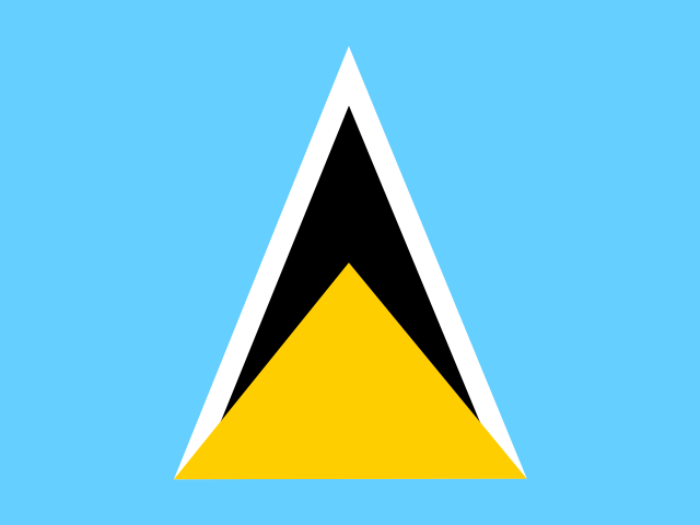
A cerulean blue flag has a gold isosceles triangle below a black arrowhead with a white border on its upper edges. Blue stands for the sky and sea, gold for sunshine and prosperity, and white and black for the ethnic composition of the island. The triangles represent Gros Piton and Petit Piton, cone-shaped volcanic plugs that are a symbol of the island. National symbols are twin pitons (volcanic peaks) and Saint Lucia parrot.
Source: CIA World Factbook · 2026-02-01 · text generated from this source, approved by a person
Key figures
CIA World Factbook
Economy
GDP (nominal)
$2.55 billion
Field “Economy → GDP (official exchange rate)” in the CIA World Factbook archive (frozen 2026-02-01). Public domain. The Factbook stopped publishing in February 2026; the year shows when the value was estimated.
GDP (PPP)
$4.36 billion
Field “Economy → Real GDP (purchasing power parity) → Real GDP (purchasing power parity) 2024” in the CIA World Factbook archive (frozen 2026-02-01). Public domain. The Factbook stopped publishing in February 2026; the year shows when the value was estimated.
GDP per capita (PPP)
$24,300
Field “Economy → Real GDP per capita → Real GDP per capita 2024” in the CIA World Factbook archive (frozen 2026-02-01). Public domain. The Factbook stopped publishing in February 2026; the year shows when the value was estimated.
GDP growth
+3.9%
Field “Economy → Real GDP growth rate → Real GDP growth rate 2024” in the CIA World Factbook archive (frozen 2026-02-01). Public domain. The Factbook stopped publishing in February 2026; the year shows when the value was estimated.
Inflation (consumer prices)
-0.1%
Field “Economy → Inflation rate (consumer prices) → Inflation rate (consumer prices) 2024” in the CIA World Factbook archive (frozen 2026-02-01). Public domain. The Factbook stopped publishing in February 2026; the year shows when the value was estimated.
Unemployment
11%
Field “Economy → Unemployment rate → Unemployment rate 2024” in the CIA World Factbook archive (frozen 2026-02-01). Public domain. The Factbook stopped publishing in February 2026; the year shows when the value was estimated.
Exports
$1.6 billion
Field “Economy → Exports → Exports 2024” in the CIA World Factbook archive (frozen 2026-02-01). Public domain. The Factbook stopped publishing in February 2026; the year shows when the value was estimated.
Imports
$1.45 billion
Field “Economy → Imports → Imports 2024” in the CIA World Factbook archive (frozen 2026-02-01). Public domain. The Factbook stopped publishing in February 2026; the year shows when the value was estimated.
People
Life expectancy
79.4 years
Field “People and Society → Life expectancy at birth → total population” in the CIA World Factbook archive (frozen 2026-02-01). Public domain. The Factbook stopped publishing in February 2026; the year shows when the value was estimated.
Median age
40.4 years
Field “People and Society → Median age → total” in the CIA World Factbook archive (frozen 2026-02-01). Public domain. The Factbook stopped publishing in February 2026; the year shows when the value was estimated.
Birth rate
11.17 per 1,000
Field “People and Society → Birth rate” in the CIA World Factbook archive (frozen 2026-02-01). Public domain. The Factbook stopped publishing in February 2026; the year shows when the value was estimated.
Death rate
8.41 per 1,000
Field “People and Society → Death rate” in the CIA World Factbook archive (frozen 2026-02-01). Public domain. The Factbook stopped publishing in February 2026; the year shows when the value was estimated.
Fertility rate
1.71 children per woman
Field “People and Society → Total fertility rate” in the CIA World Factbook archive (frozen 2026-02-01). Public domain. The Factbook stopped publishing in February 2026; the year shows when the value was estimated.
Population growth
+0.25% a year
Field “People and Society → Population growth rate” in the CIA World Factbook archive (frozen 2026-02-01). Public domain. The Factbook stopped publishing in February 2026; the year shows when the value was estimated.
Urban population
19.2%
Field “People and Society → Urbanization → urban population” in the CIA World Factbook archive (frozen 2026-02-01). Public domain. The Factbook stopped publishing in February 2026; the year shows when the value was estimated.
Languages
Englishofficial
Saint Lucian Creole
Field “People and Society → Languages” in the CIA World Factbook archive (frozen 2026-02-01). Public domain. The Factbook stopped publishing in February 2026; the year shows when the value was estimated.
Religions
Roman Catholic61.5%
Protestant25.5%includes Seventh Day Adventist 10.4%, Pentecostal 8.9%, Baptist 2.2%, Anglican 1.6%, Church of God 1.5%, other Protestant 0.9%
Rastafarian1.9%
other1.4%
Field “People and Society → Religions” in the CIA World Factbook archive (frozen 2026-02-01). Public domain. The Factbook stopped publishing in February 2026; the year shows when the value was estimated.
Land
Total area
616 km²Land 606 km² · Water 10 km²
Field “Geography → Area → total” in the CIA World Factbook archive (frozen 2026-02-01). Public domain. The Factbook stopped publishing in February 2026; the year shows when the value was estimated.
Coastline
158 km
Field “Geography → Coastline” in the CIA World Factbook archive (frozen 2026-02-01). Public domain. The Factbook stopped publishing in February 2026; the year shows when the value was estimated.
Land borders
0 km
Field “Geography → Land boundaries → total” in the CIA World Factbook archive (frozen 2026-02-01). Public domain. The Factbook stopped publishing in February 2026; the year shows when the value was estimated.
Highest point
948 m Mount Gimie
Field “Geography → Elevation → highest point” in the CIA World Factbook archive (frozen 2026-02-01). Public domain. The Factbook stopped publishing in February 2026; the year shows when the value was estimated.
Values from the CIA World Factbook archive. Each carries the year it describes; open a year for the exact source field.
 Saint Lucia