Overview
Name
Christopher Columbus originally named the island "San Juan Bautista" ("Saint John the Baptist") and the capital city and main port "Cuidad de Puerto Rico" ("Rich Port City"). Over time, the names were shortened and transposed.
Source: CIA World Factbook · 2026-02-01 · text generated from this source, approved by a person
Background
The Spanish Crown claimed Puerto Rico in 1493 after Christopher Columbus' second voyage to the Americas. Spanish colonial rule introduced African slave labor and saw the indigenous population nearly exterminated. Puerto Ricans were granted US citizenship in 1917, and popularly elected governors have served since 1948. In 1952, a constitution provided for internal self-government.
Voters chose not to alter Puerto Rico's existing political status with the US in plebiscites held in 1967, 1993, and 1998. The results of a 2012 vote left open the possibility of American statehood, while a referendum held in late 2020 showed a narrow preference for statehood. Economic recession on the island has led to a net population loss since about 2005, as residents moved to the US mainland. In 2017, Hurricane Maria was the worst storm to hit the island.
Source: CIA World Factbook · 2026-02-01 · text generated from this source, approved by a person
Geography
Between the Caribbean Sea and the North Atlantic Ocean, the Dominican Republic is an island in the Caribbean. Mostly mountainous terrain gives way to a coastal plain in the north, while precipitous mountains reach the sea along the west coast. Sandy beaches line most coastal areas.
The Dominican Republic has an important location along the Mona Passage, a key shipping lane to the Panama Canal. Many small rivers and high central mountains ensure that the land is well-watered, while the south coast is relatively dry. A fertile coastal plain belt lies in the north. Some copper and nickel occur, with potential for onshore and offshore oil. Cerro de Punta is the highest point. The Caribbean Sea is the lowest point.
Source: CIA World Factbook · 2026-02-01 · text generated from this source, approved by a person
People and society
Its people include White, Black/African American, and others, including American Indian, Alaskan Native, Native Hawaiian, and other Pacific Islander people, as well as mixed people. Spanish and English are spoken. Its religious affiliations include Roman Catholic and Protestant, largely Pentecostal, as well as other affiliations, atheism, and no religious affiliation.
Population clusters tend to be found along the coast, with the largest of these in and around San Juan. An exception is a sizeable population located in the interior of the island immediately south of the capital around Caguas. Most of the interior, particularly in the western half of the island, is dominated by the Cordillera Central mountains, where population density is low.
Source: CIA World Factbook · 2026-02-01 · text generated from this source, approved by a person
Government
An unincorporated organized territory of the US with local self-government, Puerto Rico has a republican form of territorial government with separate executive, legislative, and judicial branches. Its legal system is a civil law system based on the Spanish civil code within the US federal system. The latest constitution took effect 25 July 1952. Independence is listed as none; Puerto Rico has commonwealth status as a territory of the US. National holidays are US Independence Day, 4 July (1776), and Puerto Rico Constitution Day, 25 July (1952).
Source: CIA World Factbook · 2026-02-01 · text generated from this source, approved by a person
Flag and symbols
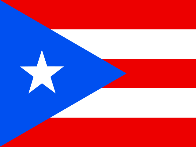
Five equal horizontal bands of red alternate with white, while a blue isosceles triangle based on the left side has a large five-pointed white star at its center. The star stands for the country, the triangle's three sides stand for the executive, legislative, and judicial branches of the government, and blue stands for the sky and the coastal waters. Red stands for the blood shed by warriors, while white stands for liberty, victory, and peace. The national symbols are the Puerto Rican spindalis (bird) and coqui (frog).
Source: CIA World Factbook · 2026-02-01 · text generated from this source, approved by a person
 Puerto Rico