The population grows 3.1% a year, at 28.55 per 1,000 births per 1,000 people.
population growth +3.1% · 7th/230 · birth rate 28.55 per 1,000 · 30th/226 CIA World Factbook · 2026-02-01 · ranks computed across the countries in this atlas that carry the value
Population
1,355,986
Natural Earth population estimate.
Area
28,051 km²
Official total area (land + water) from the CIA World Factbook. Computed from the Natural Earth boundary: ≈ 26,525 km².
Field “Economy → GDP (official exchange rate)” in the CIA World Factbook archive (frozen 2026-02-01). Public domain. The Factbook stopped publishing in February 2026; the year shows when the value was estimated.
GDP per capita (PPP)
$15,500
Field “Economy → Real GDP per capita → Real GDP per capita 2024” in the CIA World Factbook archive (frozen 2026-02-01). Public domain. The Factbook stopped publishing in February 2026; the year shows when the value was estimated.
Each line is every country in this atlas that carries the value, ordered smallest to largest. The line down the middle is the world median; the mark on each line is this country.
median
Median age22.3 years183rd of 224 · median 32.6 years
Life expectancy63.9 years207th of 224 · median 76.2 years
Fertility rate4.05 children per woman19th of 225 · median 1.92 children per woman
Population1,355,986156th of 235 · median 5,454,073
Total area28,051 km²144th of 228 · median 83,736 km²
Coastline296 km131st of 229 · median 402 km
Overview
Name
The name "Guinea" refers to a region of West Africa along the Gulf of Guinea that stretches north to the Sahel. The "equatorial" part refers to Equatorial Guinea lying just north of the Equator.
Source: CIA World Factbook · 2026-02-01 · text generated from this source, approved by a person
Geography
Between Cameroon and Gabon, Equatorial Guinea borders the Bight of Biafra in Central Africa. Its insular and continental regions are widely separated. The mainland lies just north of the equator, despite the country's name. Coastal plains rise to interior hills, while the islands are volcanic.
Its natural resources include petroleum, natural gas, timber, gold, bauxite, diamonds, tantalum, sand and gravel, and clay. Pico Basile is the country's highest point. The Atlantic Ocean marks the country's lowest point.
Source: CIA World Factbook · 2026-02-01 · text generated from this source, approved by a person
Climate
Hot, humid conditions persist year-round in Equatorial Guinea's tropical climate.
Source: CIA World Factbook · 2026-02-01 · text generated from this source, approved by a person
Government
A presidential republic governs Equatorial Guinea. Its legal system is a mixed system of civil and customary law. The current constitution followed previous constitutions in 1968, 1973, and 1982, and was approved by referendum 17 November 1991. Equatorial Guinea gained independence from Spain on 12 October 1968. The national holiday is Independence Day, 12 October (1968).
Source: CIA World Factbook · 2026-02-01 · text generated from this source, approved by a person
Flag and symbols
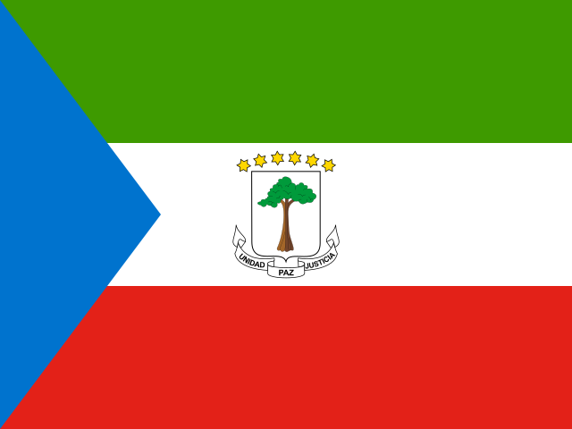
The flag has three equal horizontal bands—green, white, red—and a blue isosceles triangle based on the left side. Centered in the white band, the coat of arms has six six-pointed yellow stars representing the mainland and five offshore islands above a shield with a silk-cotton tree. Green means jungle and natural resources; blue, sea; white, peace; red, the fight for independence. The silk cotton tree is the national symbol.
Source: CIA World Factbook · 2026-02-01 · text generated from this source, approved by a person
Key figures
CIA World Factbook
Economy
GDP (nominal)
$12.77 billion
Field “Economy → GDP (official exchange rate)” in the CIA World Factbook archive (frozen 2026-02-01). Public domain. The Factbook stopped publishing in February 2026; the year shows when the value was estimated.
GDP (PPP)
$29.25 billion
Field “Economy → Real GDP (purchasing power parity) → Real GDP (purchasing power parity) 2024” in the CIA World Factbook archive (frozen 2026-02-01). Public domain. The Factbook stopped publishing in February 2026; the year shows when the value was estimated.
GDP per capita (PPP)
$15,500
Field “Economy → Real GDP per capita → Real GDP per capita 2024” in the CIA World Factbook archive (frozen 2026-02-01). Public domain. The Factbook stopped publishing in February 2026; the year shows when the value was estimated.
GDP growth
+0.9%
Field “Economy → Real GDP growth rate → Real GDP growth rate 2024” in the CIA World Factbook archive (frozen 2026-02-01). Public domain. The Factbook stopped publishing in February 2026; the year shows when the value was estimated.
Inflation (consumer prices)
4.8%
Field “Economy → Inflation rate (consumer prices) → Inflation rate (consumer prices) 2022” in the CIA World Factbook archive (frozen 2026-02-01). Public domain. The Factbook stopped publishing in February 2026; the year shows when the value was estimated.
Unemployment
7.9%
Field “Economy → Unemployment rate → Unemployment rate 2024” in the CIA World Factbook archive (frozen 2026-02-01). Public domain. The Factbook stopped publishing in February 2026; the year shows when the value was estimated.
Exports
$4.49 billion
Field “Economy → Exports → Exports 2024” in the CIA World Factbook archive (frozen 2026-02-01). Public domain. The Factbook stopped publishing in February 2026; the year shows when the value was estimated.
Imports
$3.24 billion
Field “Economy → Imports → Imports 2024” in the CIA World Factbook archive (frozen 2026-02-01). Public domain. The Factbook stopped publishing in February 2026; the year shows when the value was estimated.
People
Life expectancy
63.9 years
Field “People and Society → Life expectancy at birth → total population” in the CIA World Factbook archive (frozen 2026-02-01). Public domain. The Factbook stopped publishing in February 2026; the year shows when the value was estimated.
Median age
22.3 years
Field “People and Society → Median age → total” in the CIA World Factbook archive (frozen 2026-02-01). Public domain. The Factbook stopped publishing in February 2026; the year shows when the value was estimated.
Birth rate
28.55 per 1,000
Field “People and Society → Birth rate” in the CIA World Factbook archive (frozen 2026-02-01). Public domain. The Factbook stopped publishing in February 2026; the year shows when the value was estimated.
Death rate
8.81 per 1,000
Field “People and Society → Death rate” in the CIA World Factbook archive (frozen 2026-02-01). Public domain. The Factbook stopped publishing in February 2026; the year shows when the value was estimated.
Fertility rate
4.05 children per woman
Field “People and Society → Total fertility rate” in the CIA World Factbook archive (frozen 2026-02-01). Public domain. The Factbook stopped publishing in February 2026; the year shows when the value was estimated.
Population growth
+3.1% a year
Field “People and Society → Population growth rate” in the CIA World Factbook archive (frozen 2026-02-01). Public domain. The Factbook stopped publishing in February 2026; the year shows when the value was estimated.
Urban population
74.4%
Field “People and Society → Urbanization → urban population” in the CIA World Factbook archive (frozen 2026-02-01). Public domain. The Factbook stopped publishing in February 2026; the year shows when the value was estimated.
Religions
Roman Catholic88%
Protestant5%
Muslim2%
other5%
Field “People and Society → Religions” in the CIA World Factbook archive (frozen 2026-02-01). Public domain. The Factbook stopped publishing in February 2026; the year shows when the value was estimated.
Land
Total area
28,051 km²Land 28,051 km² · Water 0 km²
Field “Geography → Area → total” in the CIA World Factbook archive (frozen 2026-02-01). Public domain. The Factbook stopped publishing in February 2026; the year shows when the value was estimated.
Coastline
296 km
Field “Geography → Coastline” in the CIA World Factbook archive (frozen 2026-02-01). Public domain. The Factbook stopped publishing in February 2026; the year shows when the value was estimated.
Land borders
528 km
Field “Geography → Land boundaries → total” in the CIA World Factbook archive (frozen 2026-02-01). Public domain. The Factbook stopped publishing in February 2026; the year shows when the value was estimated.
Mean elevation
577 m
Field “Geography → Elevation → mean elevation” in the CIA World Factbook archive (frozen 2026-02-01). Public domain. The Factbook stopped publishing in February 2026; the year shows when the value was estimated.
Highest point
3,008 m Pico Basile
Field “Geography → Elevation → highest point” in the CIA World Factbook archive (frozen 2026-02-01). Public domain. The Factbook stopped publishing in February 2026; the year shows when the value was estimated.
Values from the CIA World Factbook archive. Each carries the year it describes; open a year for the exact source field.
 Equatorial Guinea