Name
Its name is the Spanish word for "equator," referring to its geographic position.
Source: CIA World Factbook · 2026-02-01 · text generated from this source, approved by a person
 Ecuador
1.26° S, 78.19° W
Mean elevation of 1,117 m — the 27th highest of 168 countries.
mean elevation 1,117 m · 27th/168
CIA World Factbook · 2026-02-01 · ranks computed across the countries in this atlas that carry the value
geometry: Natural Earth 1:50m · EPSG:6933 equal-area
Each line is every country in this atlas that carries the value, ordered smallest to largest. The line down the middle is the world median; the mark on each line is this country.
Its name is the Spanish word for "equator," referring to its geographic position.
Source: CIA World Factbook · 2026-02-01 · text generated from this source, approved by a person
Before the Spanish conquest in 1533, what is now Ecuador formed part of the northern Inca Empire. Quito, the traditional name for the area, became a seat of Spanish colonial government in 1563. In 1717, Quito became part of the Viceroyalty of New Granada.
The territories of the Viceroyalty—New Granada (Colombia), Venezuela, and Quito—gained independence between 1819 and 1822 and formed a federation known as Gran Colombia. When Quito withdrew to become an independent republic in 1830, the traditional name changed to the "Republic of the Equator." Between 1904 and 1942, Ecuador lost territories in a series of conflicts with its neighbors. A border war with Peru that flared in 1995 was resolved in 1999. The period of civilian governance has been marked by political instability.
Source: CIA World Factbook · 2026-02-01 · text generated from this source, approved by a person
Along the coast and in the Amazonian jungle lowlands, Ecuador has a tropical climate, while higher inland elevations are cooler. Floods and periodic droughts are natural hazards.
Source: CIA World Factbook · 2026-02-01 · text generated from this source, approved by a person
Mestizo people, meaning mixed Indigenous and White, live alongside Montubio, Indigenous, White, Afroecuadorian, Mulatto and Black communities. Spanish (Castilian) is official; indigenous languages include Quechua, while foreign and other languages include Ecuadorian sign language. Religious affiliations include Roman Catholic, Protestant, Jehovah's Witness and other faiths, while some people report none, do not know, or give no response. Protestants include Evangelical, Adventist and other Protestant affiliations.
Nearly half of the population is concentrated in the interior, with large concentrations also along the western coastal strip, while the eastern rainforests remain sparsely populated.
Source: CIA World Factbook · 2026-02-01 · text generated from this source, approved by a person
A presidential republic governs Ecuador. Its legal system is based on the Chilean civil code with modifications, alongside traditional law in ethnic communities. The latest constitution was approved 20 October 2008. Ecuador gained independence from Spain on 24 May 1822, while its national holiday, Independence Day (independence of Quito), falls on 10 August (1809).
Source: CIA World Factbook · 2026-02-01 · text generated from this source, approved by a person
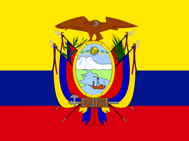
Three horizontal bands mark the flag: yellow at the top and double-width, followed by blue and red, with the coat of arms at the center. Yellow stands for sunshine, grain, and mineral wealth; blue for the sky, sea, and rivers; and red for patriots' blood spilled in the struggle for freedom and justice. The Andean condor is the national symbol.
Source: CIA World Factbook · 2026-02-01 · text generated from this source, approved by a person
CIA World Factbook
Values from the CIA World Factbook archive. Each carries the year it describes; open a year for the exact source field.
Natural Earth outlines · features with a Wikidata ID
Population · Natural Earth