Overview
Name
The name's origin is disputed, although many historians now agree that it derives from a similar-sounding word the original inhabitants used to describe themselves.
Source: CIA World Factbook · 2026-02-01 · text generated from this source, approved by a person
Background
Original Arawak Indian settlers from South America arrived on Curaçao in about 1000, but the Spanish largely enslaved them in the early 16th century and forcibly relocated them to other colonies where labor was needed. The Dutch seized Curaçao from the Spanish in 1634. Once the center of the Caribbean slave trade, Curaçao was hard hit economically when the Dutch abolished slavery in 1863.
Prosperity in Curaçao and neighboring Aruba was restored in the early 20th century with the construction of the Isla Refineria to service the newly discovered Venezuelan oilfields. In 1954, Curaçao and several other Dutch Caribbean colonies were reorganized as the Netherlands Antilles, part of the Kingdom of the Netherlands. In referenda in 2005 and 2009, citizens of Curaçao voted to become a self-governing country within the Kingdom of the Netherlands. The change in status became effective in 2010 with the dissolution of the Netherlands Antilles.
Source: CIA World Factbook · 2026-02-01 · text generated from this source, approved by a person
Geography
An island in the Caribbean Sea, Curaçao lies off the coast of Venezuela.
Curaçao is part of the Windward Islands (southern) group in the Lesser Antilles. Its terrain is generally low and hilly. Natural resources include calcium phosphates, protected harbors, and hot springs. Mt. Christoffel is Curaçao's highest point. The Caribbean Sea is its lowest point.
Source: CIA World Factbook · 2026-02-01 · text generated from this source, approved by a person
Climate
Northeast trade winds moderate Curaçao’s tropical marine climate, producing mild temperatures in a semiarid setting. Curaçao lies south of the Caribbean hurricane belt and is rarely threatened.
Source: CIA World Factbook · 2026-02-01 · text generated from this source, approved by a person
People and society
Willemstad holds the island's largest concentration of people, while smaller settlements near the coast extend throughout the island, particularly in the northwest.
Curaçao's people include Curacaoan, Dutch, Dominican, Colombian, Bonairean, Sint Eustatian, Saban, Haitian, Surinamese, Venezuelan, and Aruban communities, along with others. Residents practice Roman Catholic, Pentecostal, Protestant, Adventist, Jehovah's Witness, and Evangelical faiths, while others follow no religion.
Source: CIA World Factbook · 2026-02-01 · text generated from this source, approved by a person
Government
A parliamentary democracy governs Curaçao. Its legal system is based on Dutch civil law. The current constitution was adopted 5 September 2010 and entered into force 10 October 2010. Curaçao has no independence and is part of the Kingdom of the Netherlands. Its national holiday is King's Day, the birthday of King Willem-Alexander, on 27 April (1967).
Source: CIA World Factbook · 2026-02-01 · text generated from this source, approved by a person
Flag and symbols
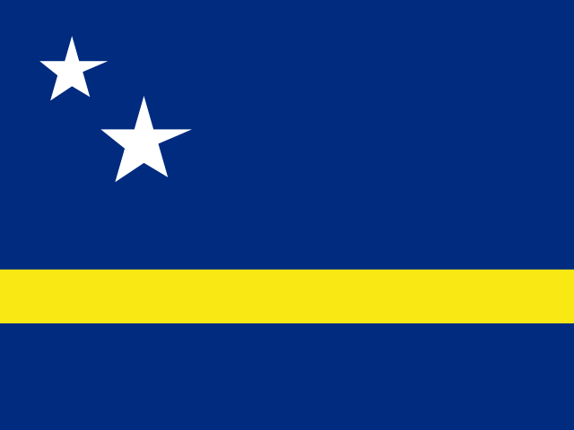
A blue flag has a horizontal yellow band below the center, with two five-pointed white stars in its upper left; the smaller star appears above and to the left of the larger. Blue stands for the sky and sea, yellow stands for the sun; stars symbolize Curaçao and its uninhabited sister island Klein Curaçao (Little Curaçao), their points representing the five continents from which Curaçao's inhabitants originate. The national symbol is laraha, a citrus tree.
Source: CIA World Factbook · 2026-02-01 · text generated from this source, approved by a person
 Curaçao