Overview
Background
First inhabited by Arawak and later by Carib Indians, the islands were settled by the Dutch in 1648 and annexed by the English in 1672. They were part of the British colony of the Leeward Islands (1872-1960) and were granted autonomy in 1967.
The economy is closely tied to the larger and more populous US Virgin Islands to the west, and the US dollar is the legal currency. In 2017, Hurricane Irma devastated the island of Tortola, destroying or damaging residential and business structures, disrupting communications, and rendering local roads impassable.
Source: CIA World Factbook · 2026-02-01 · text generated from this source, approved by a person
Geography
Set in the Caribbean between the Caribbean Sea and the North Atlantic Ocean, the British Virgin Islands lie east of Puerto Rico. Coral islands are relatively flat, while volcanic islands are steep and hilly. Their natural resources are negligible, while a pleasant climate and beaches foster tourism.
The British Virgin Islands have strong ties to the nearby US Virgin Islands and Puerto Rico. Mount Sage is the highest point. The Caribbean Sea is the lowest point.
Source: CIA World Factbook · 2026-02-01 · text generated from this source, approved by a person
Government
As an Overseas Territory of the UK with limited self-government, British Virgin Islands is governed through a parliamentary democracy. English common law forms its legal system. The latest of several previous constitutions took effect on 15 June 2007, under The Virgin Islands Constitution Order 2007. British Virgin Islands has no independence and is an overseas territory of the UK. Territory Day, on 1 July (1956), is its national holiday.
Source: CIA World Factbook · 2026-02-01 · text generated from this source, approved by a person
Flag and symbols
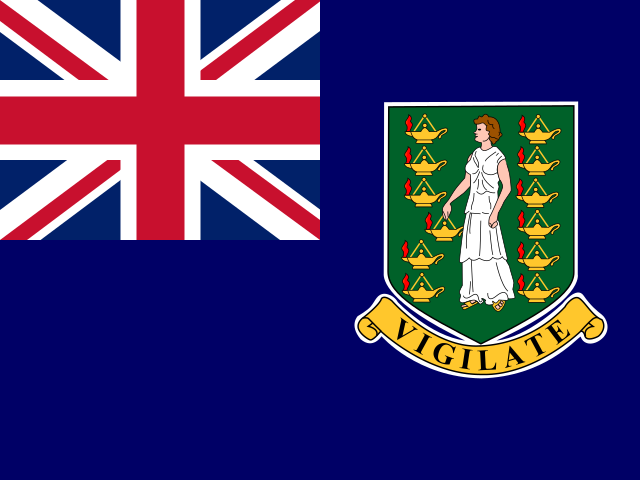
A blue flag bears the UK flag in the upper-left quadrant and the Virgin Islander coat of arms on the right half. The arms show a woman between two columns of six oil lamps above a scroll reading VIGILATE (Be Watchful). The lamp-bearing figure represents Saint Ursula, and other lamps symbolize her followers. The national symbols are the zenaida dove and white cedar flower.
Source: CIA World Factbook · 2026-02-01 · text generated from this source, approved by a person
Natural geography 2
Natural Earth outlines · features with a Wikidata ID
 British Virgin Islands