Name
Bolivia takes its name from Simón Bolívar, a 19th-century leader in the South American wars for independence.
Source: CIA World Factbook · 2026-02-01 · text generated from this source, approved by a person
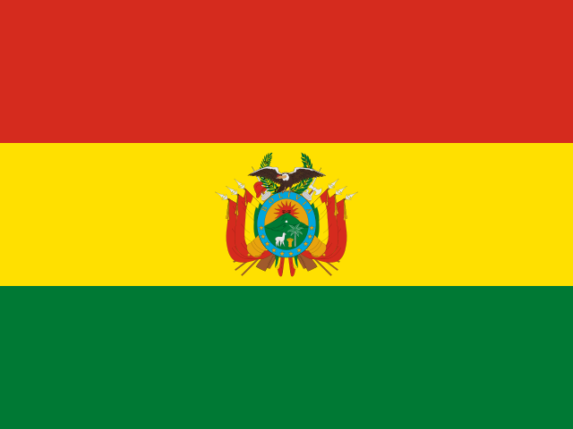 Bolivia
16.67° S, 64.59° W
No coast at all — every one of its 7,252 km of border is shared with another country.
coastline 0 km · 185th/229 · land borders 7,252 km · 14th/230
CIA World Factbook · 2026-02-01 · ranks computed across the countries in this atlas that carry the value
geometry: Natural Earth 1:50m · EPSG:6933 equal-area
Each line is every country in this atlas that carries the value, ordered smallest to largest. The line down the middle is the world median; the mark on each line is this country.
Bolivia takes its name from Simón Bolívar, a 19th-century leader in the South American wars for independence.
Source: CIA World Factbook · 2026-02-01 · text generated from this source, approved by a person
Named after independence fighter Simón Bolívar, Bolivia broke away from Spanish rule in 1825. Much of its subsequent history consisted of coups and countercoups, with the last coup occurring in 1980. Democratic civilian rule was established in 1982, but leaders faced deep-seated poverty, social unrest, and illegal drug production.
In 2005, Bolivians elected Movement Toward Socialism leader Evo Morales president by the widest margin of any leader since 1982. He ran on a promise to change the country's traditional political class and empower the poor and indigenous people. Morales easily won reelection in 2009 and 2014, while his party maintained control of the legislative branch. In 2016, Morales narrowly lost a referendum on a constitutional amendment that would have allowed him to compete in the 2019 presidential election. A subsequent Supreme Court ruling that term limits violate human rights provided justification for Morales to run, but rising violence, pressure from the military, and widespread allegations of electoral fraud ultimately forced him to flee the country. An interim government, led by President Jeanine AÑEZ Chávez, held new elections in 2020, and Luis Alberto Arce Catacora was elected president.
Source: CIA World Factbook · 2026-02-01 · text generated from this source, approved by a person
Landlocked in Central South America and southwest of Brazil, Bolivia shares control of Lago Titicaca with Peru. Lago Titicaca is the world's highest navigable lake.
The terrain includes the rugged Andes Mountains, the highland plateau Altiplano, hills, and lowland plains of the Amazon Basin. Nevado Sajama is the highest point. Rio Paraguay is the lowest point. Natural resources include lithium, tin, natural gas, petroleum, zinc, tungsten, antimony, silver, iron, lead, gold, timber, and hydropower.
Source: CIA World Factbook · 2026-02-01 · text generated from this source, approved by a person
Mestizo people, with mixed White and Indigenous ancestry, live alongside Indigenous, White, Cholo/Chola, and people of African descent, while other Indigenous groups are predominantly Quechua or Aymara. Spanish, Quechua, Aymara, and Guarani are official languages, and the country also uses other languages.
Roman Catholic and Protestant affiliations are present; Protestant affiliations include Evangelical (non-specific), Evangelical Baptist, Evangelical Pentecostal, Evangelical Methodist, Adventist, and Protestant (non-specific) believers. Believers not belonging to the church, atheists, agnostics, and people with no religion are also present, along with other affiliations. The Altiplano, a high-altitude plain in the west between two cordillera of the Andes, is the focal area for most of the population. A dense settlement pattern is also found in and around Santa Cruz, on the eastern side of the Andes.
Source: CIA World Factbook · 2026-02-01 · text generated from this source, approved by a person
A presidential republic governs the country. Its legal system is a civil law system with influences from Roman, Spanish, canon (religious), French, and ethnic groups' pre-colonial law. The latest constitution was drafted 6 August 2006 to 9 December 2008, approved by referendum 25 January 2009, and took effect 7 February 2009. Independence came from Spain on 6 August 1825. The national holiday is Independence Day, 6 August (1825).
Source: CIA World Factbook · 2026-02-01 · text generated from this source, approved by a person
The flag has three equal horizontal bands: red at the top, yellow in the middle, and green below, with the coat of arms centered on the yellow band. Red stands for bravery and the blood of national heroes; yellow stands for the nation's mineral resources, and green for the land's fertility. In 2009, a presidential decree required a wiphala alongside the national flag. National symbols include the llama and Andean condor; cantuta and patuju are national flowers.
Source: CIA World Factbook · 2026-02-01 · text generated from this source, approved by a person
CIA World Factbook
Values from the CIA World Factbook archive. Each carries the year it describes; open a year for the exact source field.
Natural Earth outlines · features with a Wikidata ID
Population · Natural Earth