Field “Economy → GDP (official exchange rate)” in the CIA World Factbook archive (frozen 2026-02-01). Public domain. The Factbook stopped publishing in February 2026; the year shows when the value was estimated.
GDP per capita (PPP)
$30,200
Field “Economy → Real GDP per capita → Real GDP per capita 2024” in the CIA World Factbook archive (frozen 2026-02-01). Public domain. The Factbook stopped publishing in February 2026; the year shows when the value was estimated.
Each line is every country in this atlas that carries the value, ordered smallest to largest. The line down the middle is the world median; the mark on each line is this country.
median
Median age38.9 years73rd of 224 · median 32.6 years
Life expectancy80.3 years52nd of 224 · median 76.2 years
Fertility rate1.25 children per woman211th of 225 · median 1.92 children per woman
Population18,952,03862nd of 235 · median 5,454,073
Total area756,102 km²39th of 228 · median 83,736 km²
Coastline6,435 km21st of 229 · median 402 km
Overview
Name
The origin of Chile's name is unclear. It may come from a local word meaning either "land's end" or "cold," or from a local word confused with the Mexican Spanish word "chili," meaning a chili pepper, in reference to the area's shape.
Source: CIA World Factbook · 2026-02-01 · text generated from this source, approved by a person
Geography
Southern South America borders the South Pacific Ocean between Argentina and Peru. Its terrain runs from low coastal mountains through a fertile central valley to the rugged Andes in the east. Natural resources include copper, timber, iron ore, nitrates, precious metals, molybdenum, and hydropower.
Chile lies along the Ring of Fire, a belt bordering the Pacific Ocean that contains volcanoes and earthquakes. In the north, the Atacama Desert is the driest desert in the world. Ojos del Salado in the Atacama Desert is the highest active volcano in the world and Chile's tallest mountain. Its small crater lake is the world's highest lake.
Source: CIA World Factbook · 2026-02-01 · text generated from this source, approved by a person
Climate
Regional conditions include desert in the north, Mediterranean conditions in the central region, and cool, damp conditions in the south, within a temperate climate.
Source: CIA World Factbook · 2026-02-01 · text generated from this source, approved by a person
Government
A presidential republic governs Chile. Its legal system is a civil law system influenced by several Western European civil legal systems; the Constitutional Tribunal reviews legislative acts. The latest constitution was adopted 11 September 1980, took effect 11 March 1981, and remains in force. Independence from Spain dates to 18 September 1810. The national holiday is Independence Day, 18 September (1810).
Source: CIA World Factbook · 2026-02-01 · text generated from this source, approved by a person
Flag and symbols
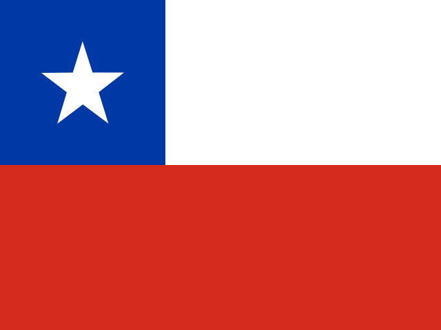
Two equal horizontal bands of white (top) and red form the flag, with a blue square in the top left corner, the same height as the white band. The square has a five-pointed white star in its center, representing a guide to progress and honor; blue stands for the sky, white for the Andes Mountains, and red for the blood spilled to achieve independence. The national symbols are the huemul (mountain deer) and Andean condor.
Source: CIA World Factbook · 2026-02-01 · text generated from this source, approved by a person
Key figures
CIA World Factbook
Economy
GDP (nominal)
$330.27 billion
Field “Economy → GDP (official exchange rate)” in the CIA World Factbook archive (frozen 2026-02-01). Public domain. The Factbook stopped publishing in February 2026; the year shows when the value was estimated.
GDP (PPP)
$596.56 billion
Field “Economy → Real GDP (purchasing power parity) → Real GDP (purchasing power parity) 2024” in the CIA World Factbook archive (frozen 2026-02-01). Public domain. The Factbook stopped publishing in February 2026; the year shows when the value was estimated.
GDP per capita (PPP)
$30,200
Field “Economy → Real GDP per capita → Real GDP per capita 2024” in the CIA World Factbook archive (frozen 2026-02-01). Public domain. The Factbook stopped publishing in February 2026; the year shows when the value was estimated.
GDP growth
+2.6%
Field “Economy → Real GDP growth rate → Real GDP growth rate 2024” in the CIA World Factbook archive (frozen 2026-02-01). Public domain. The Factbook stopped publishing in February 2026; the year shows when the value was estimated.
Inflation (consumer prices)
4.3%
Field “Economy → Inflation rate (consumer prices) → Inflation rate (consumer prices) 2024” in the CIA World Factbook archive (frozen 2026-02-01). Public domain. The Factbook stopped publishing in February 2026; the year shows when the value was estimated.
Unemployment
9.1%
Field “Economy → Unemployment rate → Unemployment rate 2024” in the CIA World Factbook archive (frozen 2026-02-01). Public domain. The Factbook stopped publishing in February 2026; the year shows when the value was estimated.
Exports
$111.12 billion
Field “Economy → Exports → Exports 2024” in the CIA World Factbook archive (frozen 2026-02-01). Public domain. The Factbook stopped publishing in February 2026; the year shows when the value was estimated.
Imports
$99.24 billion
Field “Economy → Imports → Imports 2024” in the CIA World Factbook archive (frozen 2026-02-01). Public domain. The Factbook stopped publishing in February 2026; the year shows when the value was estimated.
People
Life expectancy
80.3 years
Field “People and Society → Life expectancy at birth → total population” in the CIA World Factbook archive (frozen 2026-02-01). Public domain. The Factbook stopped publishing in February 2026; the year shows when the value was estimated.
Median age
38.9 years
Field “People and Society → Median age → total” in the CIA World Factbook archive (frozen 2026-02-01). Public domain. The Factbook stopped publishing in February 2026; the year shows when the value was estimated.
Birth rate
8.81 per 1,000
Field “People and Society → Birth rate” in the CIA World Factbook archive (frozen 2026-02-01). Public domain. The Factbook stopped publishing in February 2026; the year shows when the value was estimated.
Death rate
6.79 per 1,000
Field “People and Society → Death rate” in the CIA World Factbook archive (frozen 2026-02-01). Public domain. The Factbook stopped publishing in February 2026; the year shows when the value was estimated.
Fertility rate
1.25 children per woman
Field “People and Society → Total fertility rate” in the CIA World Factbook archive (frozen 2026-02-01). Public domain. The Factbook stopped publishing in February 2026; the year shows when the value was estimated.
Population growth
+0.46% a year
Field “People and Society → Population growth rate” in the CIA World Factbook archive (frozen 2026-02-01). Public domain. The Factbook stopped publishing in February 2026; the year shows when the value was estimated.
Urban population
88%
Field “People and Society → Urbanization → urban population” in the CIA World Factbook archive (frozen 2026-02-01). Public domain. The Factbook stopped publishing in February 2026; the year shows when the value was estimated.
Literacy
96.4%
Field “People and Society → Literacy → total population” in the CIA World Factbook archive (frozen 2026-02-01). Public domain. The Factbook stopped publishing in February 2026; the year shows when the value was estimated.
Land
Total area
756,102 km²Land 743,812 km² · Water 12,290 km²
Field “Geography → Area → total” in the CIA World Factbook archive (frozen 2026-02-01). Public domain. The Factbook stopped publishing in February 2026; the year shows when the value was estimated.
Coastline
6,435 km
Field “Geography → Coastline” in the CIA World Factbook archive (frozen 2026-02-01). Public domain. The Factbook stopped publishing in February 2026; the year shows when the value was estimated.
Land borders
7,801 km
Field “Geography → Land boundaries → total” in the CIA World Factbook archive (frozen 2026-02-01). Public domain. The Factbook stopped publishing in February 2026; the year shows when the value was estimated.
Mean elevation
1,871 m
Field “Geography → Elevation → mean elevation” in the CIA World Factbook archive (frozen 2026-02-01). Public domain. The Factbook stopped publishing in February 2026; the year shows when the value was estimated.
Values from the CIA World Factbook archive. Each carries the year it describes; open a year for the exact source field.
 Chile
Chile