No land border at all — every neighbor is across water, along 97 km of coast, the 159th longest on Earth.
land borders 0 km · 164th/230 · coastline 97 km · 159th/229 CIA World Factbook · 2026-02-01 · ranks computed across the countries in this atlas that carry the value
Population
287,025
Natural Earth population estimate.
Area
430 km²
Official total area (land + water) from the CIA World Factbook. Computed from the Natural Earth boundary: ≈ 388 km².
Field “Economy → GDP (official exchange rate)” in the CIA World Factbook archive (frozen 2026-02-01). Public domain. The Factbook stopped publishing in February 2026; the year shows when the value was estimated.
GDP per capita (PPP)
$19,900
Field “Economy → Real GDP per capita → Real GDP per capita 2024” in the CIA World Factbook archive (frozen 2026-02-01). Public domain. The Factbook stopped publishing in February 2026; the year shows when the value was estimated.
Each line is every country in this atlas that carries the value, ordered smallest to largest. The line down the middle is the world median; the mark on each line is this country.
median
Median age42.2 years46th of 224 · median 32.6 years
Life expectancy79 years67th of 224 · median 76.2 years
Fertility rate1.24 children per woman215th of 225 · median 1.92 children per woman
Population287,025183rd of 235 · median 5,454,073
Total area430 km²197th of 228 · median 83,736 km²
Coastline97 km159th of 229 · median 402 km
Overview
Name
The name comes from the plural Spanish word "barbado," meaning "the bearded ones," which could refer either to fig-tree leaves or Carib inhabitants' beards.
Source: CIA World Factbook · 2026-02-01 · text generated from this source, approved by a person
Background
When the British first settled the island in 1627, Barbados was uninhabited. Enslaved Africans worked the sugar plantations established there, which initially dominated the Caribbean sugar industry. By 1720, the Leeward Islands and Jamaica had surpassed Barbados, which was no longer dominant within the sugar industry. Slavery was abolished in 1834.
Through most of the 20th century, the Barbadian economy remained heavily dependent on sugar, rum, and molasses production. Social and political reforms introduced gradually in the 1940s and 1950s led to independence from the UK in 1966. In the 1990s, tourism and manufacturing surpassed the sugar industry in economic importance. In 2021, Barbados became a republic, and former Governor-General Sandra Mason was elected its first president.
Source: CIA World Factbook · 2026-02-01 · text generated from this source, approved by a person
Geography
The easternmost Caribbean island is Barbados. It lies in the North Atlantic Ocean, northeast of Venezuela. Its terrain is relatively flat and rises gently to a central highland region.
Barbados's natural resources include petroleum, fish, and natural gas. Mount Hillaby is the highest point. The Atlantic Ocean is the lowest point.
Source: CIA World Factbook · 2026-02-01 · text generated from this source, approved by a person
Flag and symbols
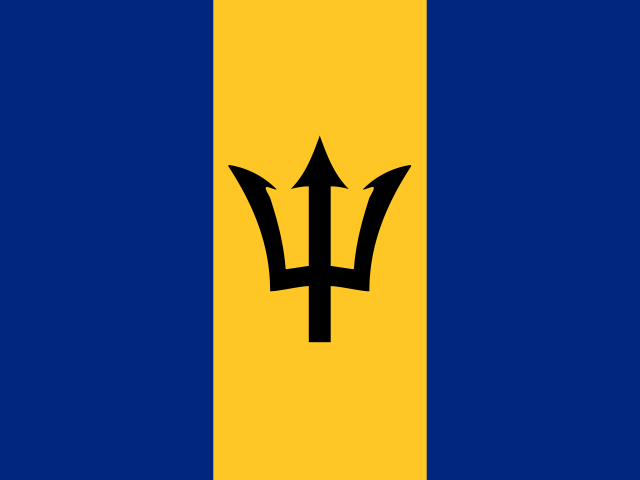
Three equal vertical bands—ultramarine blue at left, gold at center, and ultramarine blue at right—carry a black trident head centered on the gold band. Blue stands for the sea and sky, gold for the beaches, and the trident head represents independence and a break with the past. National symbols include Neptune's trident, pelican, and the red bird of paradise flower, also known as 'Pride of Barbados'.
Source: CIA World Factbook · 2026-02-01 · text generated from this source, approved by a person
Key figures
CIA World Factbook
Economy
GDP (nominal)
$7.17 billion
Field “Economy → GDP (official exchange rate)” in the CIA World Factbook archive (frozen 2026-02-01). Public domain. The Factbook stopped publishing in February 2026; the year shows when the value was estimated.
GDP (PPP)
$5.63 billion
Field “Economy → Real GDP (purchasing power parity) → Real GDP (purchasing power parity) 2024” in the CIA World Factbook archive (frozen 2026-02-01). Public domain. The Factbook stopped publishing in February 2026; the year shows when the value was estimated.
GDP per capita (PPP)
$19,900
Field “Economy → Real GDP per capita → Real GDP per capita 2024” in the CIA World Factbook archive (frozen 2026-02-01). Public domain. The Factbook stopped publishing in February 2026; the year shows when the value was estimated.
GDP growth
+3.8%
Field “Economy → Real GDP growth rate → Real GDP growth rate 2024” in the CIA World Factbook archive (frozen 2026-02-01). Public domain. The Factbook stopped publishing in February 2026; the year shows when the value was estimated.
Inflation (consumer prices)
-0.5%
Field “Economy → Inflation rate (consumer prices) → Inflation rate (consumer prices) 2024” in the CIA World Factbook archive (frozen 2026-02-01). Public domain. The Factbook stopped publishing in February 2026; the year shows when the value was estimated.
Unemployment
7.6%
Field “Economy → Unemployment rate → Unemployment rate 2024” in the CIA World Factbook archive (frozen 2026-02-01). Public domain. The Factbook stopped publishing in February 2026; the year shows when the value was estimated.
Exports
$2.23 billion
Field “Economy → Exports → Exports 2017” in the CIA World Factbook archive (frozen 2026-02-01). Public domain. The Factbook stopped publishing in February 2026; the year shows when the value was estimated.
Imports
$2.12 billion
Field “Economy → Imports → Imports 2021” in the CIA World Factbook archive (frozen 2026-02-01). Public domain. The Factbook stopped publishing in February 2026; the year shows when the value was estimated.
People
Life expectancy
79 years
Field “People and Society → Life expectancy at birth → total population” in the CIA World Factbook archive (frozen 2026-02-01). Public domain. The Factbook stopped publishing in February 2026; the year shows when the value was estimated.
Median age
42.2 years
Field “People and Society → Median age → total” in the CIA World Factbook archive (frozen 2026-02-01). Public domain. The Factbook stopped publishing in February 2026; the year shows when the value was estimated.
Birth rate
8.02 per 1,000
Field “People and Society → Birth rate” in the CIA World Factbook archive (frozen 2026-02-01). Public domain. The Factbook stopped publishing in February 2026; the year shows when the value was estimated.
Death rate
11.96 per 1,000
Field “People and Society → Death rate” in the CIA World Factbook archive (frozen 2026-02-01). Public domain. The Factbook stopped publishing in February 2026; the year shows when the value was estimated.
Fertility rate
1.24 children per woman
Field “People and Society → Total fertility rate” in the CIA World Factbook archive (frozen 2026-02-01). Public domain. The Factbook stopped publishing in February 2026; the year shows when the value was estimated.
Population growth
-0.42% a year
Field “People and Society → Population growth rate” in the CIA World Factbook archive (frozen 2026-02-01). Public domain. The Factbook stopped publishing in February 2026; the year shows when the value was estimated.
Urban population
31.4%
Field “People and Society → Urbanization → urban population” in the CIA World Factbook archive (frozen 2026-02-01). Public domain. The Factbook stopped publishing in February 2026; the year shows when the value was estimated.
Languages
Englishofficial
Bajan
Field “People and Society → Languages” in the CIA World Factbook archive (frozen 2026-02-01). Public domain. The Factbook stopped publishing in February 2026; the year shows when the value was estimated.
Religions
Protestant66.4%includes Anglican 23.9%, other Pentecostal 19.5%, Adventist 5.9%, Methodist 4.2%, Wesleyan 3.4%, Nazarene 3.2%, Church of God 2.4%, Baptist 1.8%, Moravian 1.2%, other Protestant 0.9%
Roman Catholic3.8%
Rastafarian1%
other1.2%
Field “People and Society → Religions” in the CIA World Factbook archive (frozen 2026-02-01). Public domain. The Factbook stopped publishing in February 2026; the year shows when the value was estimated.
Land
Total area
430 km²Land 430 km² · Water 0 km²
Field “Geography → Area → total” in the CIA World Factbook archive (frozen 2026-02-01). Public domain. The Factbook stopped publishing in February 2026; the year shows when the value was estimated.
Coastline
97 km
Field “Geography → Coastline” in the CIA World Factbook archive (frozen 2026-02-01). Public domain. The Factbook stopped publishing in February 2026; the year shows when the value was estimated.
Land borders
0 km
Field “Geography → Land boundaries → total” in the CIA World Factbook archive (frozen 2026-02-01). Public domain. The Factbook stopped publishing in February 2026; the year shows when the value was estimated.
Highest point
336 m Mount Hillaby
Field “Geography → Elevation → highest point” in the CIA World Factbook archive (frozen 2026-02-01). Public domain. The Factbook stopped publishing in February 2026; the year shows when the value was estimated.
Values from the CIA World Factbook archive. Each carries the year it describes; open a year for the exact source field.
 Barbados