Overview
Name
The name Bahamas may be derived from the Spanish "baha mar," meaning "low sea," which describes the shallow waters of the Bahama Banks. Alternatively, it may be a form of the local name "Guanahani," whose origin and meaning are unknown.
Source: CIA World Factbook · 2026-02-01 · text generated from this source, approved by a person
Background
Lucayan Indians inhabited the islands when Christopher Columbus first set foot in the New World in 1492. British settlement of the islands began in 1647, and the islands became a colony in 1783. Piracy thrived in the 17th and 18th centuries because of the Bahamas' close proximity to shipping lanes.
Since gaining independence from the UK in 1973, the Bahamas has prospered through tourism, international banking, and investment management. Because of its proximity to the US, the country is a major transshipment point for illicit trafficking to the US mainland and Europe. US law enforcement agencies cooperate closely with the Bahamas. The Drug Enforcement Administration, US Coast Guard, and US Customs and Border Protection assist Bahamian authorities with maritime security and law enforcement through Operation Bahamas, Turks and Caicos, or OPBAT.
Source: CIA World Factbook · 2026-02-01 · text generated from this source, approved by a person
Geography
Long, flat coral formations shape the terrain, with some low rounded hills. Bahamas comprises a chain of islands in the North Atlantic Ocean, southeast of Florida and northeast of Cuba. Although it does not border the Caribbean Sea, the country is often designated geopolitically as a Caribbean nation.
Natural resources include salt, aragonite, timber, and arable land. The extensive island chain has a strategic location adjacent to the US and Cuba and includes inhabited islands. The highest point lies northeast of Old Bight on Cat Island. The Atlantic Ocean is the lowest point.
Source: CIA World Factbook · 2026-02-01 · text generated from this source, approved by a person
Climate
A tropical marine climate is moderated by the warm waters of the Gulf Stream. Hurricanes and other tropical storms cause extensive flood and wind damage.
Source: CIA World Factbook · 2026-02-01 · text generated from this source, approved by a person
Government
A parliamentary democracy under a constitutional monarchy, the Bahamas is a Commonwealth realm. Its legal system is a common-law system based on the English model. The latest constitution was adopted 20 June 1973 and took effect 10 July 1973. The Bahamas gained independence from the UK on 10 July 1973. Independence Day, 10 July (1973), is the national holiday.
Source: CIA World Factbook · 2026-02-01 · text generated from this source, approved by a person
Flag and symbols
Three equal horizontal bands—aquamarine at top, gold, and aquamarine—are paired with a black equilateral triangle based on the left side. The band colors represent the islands' golden beaches surrounded by the aquamarine sea; black stands for the vigor and force of a united people, and the triangle for the people's enterprise and determination. The national symbols are the blue marlin, flamingo, and yellow elderflower.
Source: CIA World Factbook · 2026-02-01 · text generated from this source, approved by a person
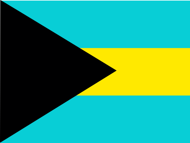 Bahamas