9 cities

Location of AzerbaijanKazakhstanTürkiyeIranTurkmenistanArmeniaIraqUzbekistanSyriaGeorgiaAzerbaijanSakiShirvanBakuLankaranYevlaxGancaNaxcivanStepanakertSumqayt
CountryTranscontinental

Azerbaijan

40.40° N, 47.21° E

No coast at all — every one of its 2,468 km of border is shared with another country.

coastline 0 km · 185th/229 · land borders 2,468 km · 78th/230
CIA World Factbook · 2026-02-01 · ranks computed across the countries in this atlas that carry the value

Population
10,023,318
Area
86,600 km²
Population density
≈ 116 / km²
Capital
Baku
Natural Earth
ISO codes
AZ · AZE
GDP (nominal)
$74.32 billion
GDP per capita (PPP)
$22,100
How big, reallyDrawn at the same scale as Georgia. Equal-area projection, not the map you are used to.
Azerbaijan 86,600 km²Georgia 69,700 km²

geometry: Natural Earth 1:50m · EPSG:6933 equal-area

Where Azerbaijan sits in the world

Each line is every country in this atlas that carries the value, ordered smallest to largest. The line down the middle is the world median; the mark on each line is this country.

  1. Median age34.8 years99th of 224 · median 32.6 years
  2. Life expectancy75.9 years118th of 224 · median 76.2 years
  3. Fertility rate1.69 children per woman152nd of 225 · median 1.92 children per woman
  4. Population10,023,31891st of 235 · median 5,454,073
  5. Total area86,600 km²113th of 228 · median 83,736 km²
  6. Coastline0 km185th of 229 · median 402 km

Overview

Name

The name Azerbaijan can be translated as "Fire Keeper" or "The Land of Fire", from the local "azer", meaning "fire", and "baydjan", derived from the Iranian "baykan", meaning "guardian"; it may refer to fire worshippers who lived in the region.

Source: CIA World Factbook · 2026-02-01 · text generated from this source, approved by a person

People and society

The country's ethnic groups include Azerbaijani, Talish, Russian, Avar, Sakhur, Tartar, Georgian, Jewish, and Kurd. Its languages include Azerbaijani, Russian, Avar, Talyshi, Turkish, Tatar, Sakhur, Tat, Ukrainian, Georgian, and Hebrew. The religious affiliations are Muslim, predominantly Shia, Christian, other affiliations, and unaffiliated.

The highest population density is found in the far eastern area of the country, in and around Baku. Apart from smaller urbanized areas, the rest of the country has a fairly light and evenly distributed population.

Source: CIA World Factbook · 2026-02-01 · text generated from this source, approved by a person

Flag and symbols

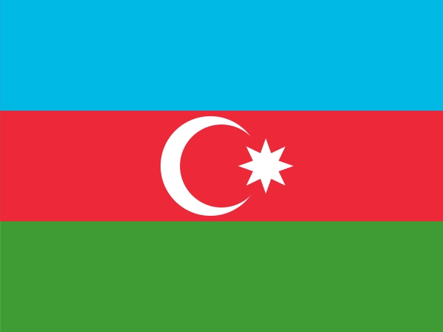
Three equal horizontal bands of sky blue, red, and green run from top to bottom, with a vertical white crescent moon and eight-pointed star centered in the red band. The blue band stands for Azerbaijan's Turkic heritage, red for modernization and progress, and green for Islam; the crescent and star are a Turkic insignia. The star's eight points represent the eight Turkic peoples of the world. The national symbol is flames of fire.

Source: CIA World Factbook · 2026-02-01 · text generated from this source, approved by a person
Key figures

CIA World Factbook

Economy

GDP (nominal)
$74.32 billion
GDP (PPP)
$225.2 billion
GDP per capita (PPP)
$22,100
GDP growth
+4.1%
Inflation (consumer prices)
2.2%
Unemployment
5.6%
Exports
$34.11 billion
Imports
$27.34 billion

People

Life expectancy
75.9 years
Median age
34.8 years
Birth rate
11.13 per 1,000
Death rate
6.44 per 1,000
Fertility rate
1.69 children per woman
Population growth
+0.4% a year
Urban population
57.6%
Literacy
99.8%

Land

Total area
86,600 km²Land 82,629 km² · Water 3,971 km²
Coastline
0 km
Land borders
2,468 km
Mean elevation
384 m
Highest point
4,466 m Bazarduzu Dagi

Values from the CIA World Factbook archive. Each carries the year it describes; open a year for the exact source field.

Connections

Natural geography 4

Natural Earth outlines · features with a Wikidata ID

Peninsulas 1

Largest cities 9

Population · Natural Earth

  1. Bakucapital2.1M
  2. Ganca303.3K
  3. Sumqayt279.2K
  4. Naxcivan94.8K
  5. Shirvan70.7K
  6. Saki65K
  7. Lankaran60.2K
  8. Stepanakert57.5K
  9. Yevlax53.7K

Sources