Overview
Name
Aruba's name has an unclear origin; tradition links it to the Spanish phrase "oro hubo" ("there was gold"), though no gold was ever found on the island. Other possible sources are "oruba" ("well-situated") or the Carib Indian words "ora" and "oubao" ("shell" and "island").
Source: CIA World Factbook · 2026-02-01 · text generated from this source, approved by a person
Background
Spain discovered and claimed Aruba in 1499, before the Dutch acquired the island in 1636. Three main industries—gold mining, oil refining, and tourism—have since dominated the island's economy. A 19th-century gold rush was followed by prosperity after an oil refinery opened in 1924. The last decades of the 20th century brought a boom in tourism.
Aruba seceded from the Netherlands Antilles in 1986 and became a separate, semi-autonomous member of the Kingdom of the Netherlands. The movement toward full independence was halted at Aruba's request in 1990.
Source: CIA World Factbook · 2026-02-01 · text generated from this source, approved by a person
Geography
White sandy beaches mark this flat, riverless island. Aruba lies in the Caribbean Sea, north of Venezuela. The island has flat terrain, a few hills, and scant vegetation.
Constant trade winds from the Atlantic Ocean moderate its tropical climate. Its temperature is almost constant. Natural resources are negligible, while white sandy beaches foster tourism. Ceru Jamanota is the highest point. The Caribbean Sea is the lowest point.
Source: CIA World Factbook · 2026-02-01 · text generated from this source, approved by a person
Climate
Little seasonal temperature variation characterizes Aruba's tropical marine climate. Aruba lies outside the Caribbean hurricane belt and is rarely threatened by hurricanes.
Source: CIA World Factbook · 2026-02-01 · text generated from this source, approved by a person
Government
As part of the Kingdom of the Netherlands, Aruba is governed as a parliamentary democracy. Its legal system is a civil law system based on the Dutch civil code. Aruba's constitution was drafted and approved in August 1985 and enacted 1 January 1986; it regulates Aruba's governance and is subordinate to the Charter for the Kingdom of the Netherlands. Aruba has no independence and is part of the Kingdom of the Netherlands. Aruba's national holiday is National Anthem and Flag Day, 18 March (1976).
Source: CIA World Factbook · 2026-02-01 · text generated from this source, approved by a person
Flag and symbols
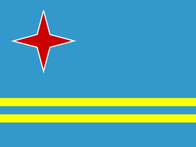
Blue flag combines two narrow horizontal yellow stripes across its lower portion with a red four-pointed star outlined in white in its upper-left corner. The star stands for Aruba's red soil and white beaches; its points represent Papiamento, Dutch, Spanish, English, and compass points, indicating inhabitants from all over the world. Blue symbolizes Caribbean waters and skies; stripes represent tourism and mining. Hooiberg (Haystack) Hill is Aruba's national symbol.
Source: CIA World Factbook · 2026-02-01 · text generated from this source, approved by a person
 Aruba
Aruba