Overview
Name
Originally, the name "Afghan" referred to the Pashtun people, but today it is understood to include all the country's ethnic groups. The suffix "-stan" means "place of" or "country," so Afghanistan literally means the "Land of the Afghans."
Source: CIA World Factbook · 2026-02-01 · text generated from this source, approved by a person
Geography
Landlocked in Southern Asia, Afghanistan lies north and west of Pakistan and east of Iran. Mostly rugged mountains cover the country, with plains in the north and southwest.
The Hindu Kush mountains run northeast to southwest, dividing the northern provinces from the rest of the country. The highest peaks are in the northern Vakhan (Wakhan Corridor). Noshak is the country's highest point, while the Amu Darya is its lowest point. Natural gas, petroleum, coal, copper, chromite, talc, barites, sulfur, lead, zinc, iron ore, salt, precious and semiprecious stones, and arable land are listed among its natural resources.
Source: CIA World Factbook · 2026-02-01 · text generated from this source, approved by a person
Climate
The climate is arid to semiarid, with cold winters and hot summers.
Source: CIA World Factbook · 2026-02-01 · text generated from this source, approved by a person
People and society
Reliable statistical data on Afghanistan's ethnic composition are not available. Afghanistan's Constitution cited Pashtun, Tajik, Hazara, Uzbek, Turkman, Baluch, Pashaie, Nuristani, Aymaq, Arab, Qirghiz, Qizilbash, Gujur, and Brahwui ethnicities. Afghanistan also has other small ethnic groups. Afghan Persian or Dari is official and serves as a lingua franca, while Pashto is also official. Other languages include Uzbeki, English, Turkmani, Urdu, Pashaie, Nuristani, Arabic, and Balochi.
Muslims include Sunni and Shia communities, and other religions are also present. People cluster in the foothills and periphery of the rugged Hindu Kush range, with smaller groups in many interior valleys. The east is more densely settled, while the south is sparsely populated.
Source: CIA World Factbook · 2026-02-01 · text generated from this source, approved by a person
Government
The Taliban Government is a theocracy; the United States does not recognize it. The Taliban is implementing its own interpretation of Islamic law, partially based on the Hanifi school of Islamic jurisprudence, and enforcing punishments. The latest constitution was ratified in 2004 but is not currently enforced by the Taliban. Afghanistan became independent on 19 August 1919 from UK control over Afghan foreign affairs. Under the Taliban Government, 15 August (2022) is declared a national holiday marking the anniversary of the victory of the Afghan jihad.
Source: CIA World Factbook · 2026-02-01 · text generated from this source, approved by a person
Flag and symbols
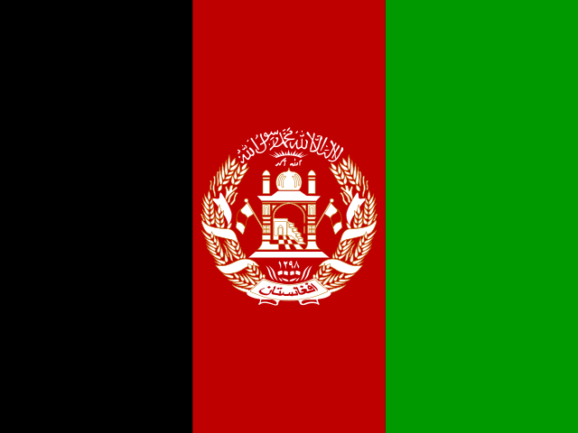
Three equal vertical bands—black, red, and green—form the flag; a white emblem is centered on the red and overlaps others. It shows a mosque, pulpit, flags on either side, wheat sheaves circling it, and a scroll naming Afghanistan. Black stands for the past, red for blood shed for independence, and green can represent hope for the future, agricultural prosperity, or Islam. The national symbol is a lion.
Source: CIA World Factbook · 2026-02-01 · text generated from this source, approved by a person
 Afghanistan