Overview
Name
The name derives from the Uruguay River, which makes up the country's western border. Uruguay comes from the Guarani words "uru," meaning bird, and "guay," meaning tail.
Source: CIA World Factbook · 2026-02-01 · text generated from this source, approved by a person
Background
A natural harbor helped Montevideo become an important commercial center soon after the Spanish founded it as a military stronghold in 1726. Argentina initially claimed Uruguay, while Brazil annexed the country in 1821. Uruguay declared its independence in 1825 and secured its freedom in 1828 after a struggle. Administrations of President Jose Batlle in the early 20th century launched widespread political, social, and economic reforms that established a statist tradition.
A violent Marxist urban guerrilla movement named the Tupamaros, or Movimiento de Liberación Nacional-Tupamaros, launched in the late 1960s. It pushed Uruguay's president to cede control of the government to the military in 1973. By year-end, the rebels had been crushed, but the military continued to expand its hold over the government. Civilian rule was restored in 1985. In 2004, the left-of-center Frente Amplio (FA) Coalition won national elections, ending political control by the Colorado and National (Blanco) parties. The coalition retained the presidency and control of both chambers of congress until 2019. Uruguay's political and labor conditions are among the freest on the South American continent.
Source: CIA World Factbook · 2026-02-01 · text generated from this source, approved by a person
Geography
Between Argentina and Brazil, Uruguay borders the South Atlantic Ocean in southern South America. Its terrain consists of mostly rolling plains and low hills, with fertile coastal lowland.
Grassland in the low-lying landscape is ideal for cattle and sheep. Arable land, hydropower, minor minerals, and fish are natural resources. Cerro Catedral is the highest point. The Atlantic Ocean is the lowest point.
Source: CIA World Factbook · 2026-02-01 · text generated from this source, approved by a person
Climate
Warm temperate conditions prevail, and freezing temperatures are almost unknown. Natural hazards include seasonally high winds, droughts, and floods; the pampero is a chilly and occasional violent wind that blows north from the Argentine pampas. Without mountains to act as weather barriers, all locations are particularly vulnerable to rapid changes from weather fronts.
Source: CIA World Factbook · 2026-02-01 · text generated from this source, approved by a person
People and society
Most of Uruguay's population resides in its southern half, while the country has an urban population. People live in and around Montevideo.
Uruguay's population includes White, Black, and Indigenous people, along with others. Spanish is the official language, and Rioplatense is the most widely spoken dialect. Religious affiliations include Roman Catholic, Protestant, African American Cults/Umbanda, Jehovah's Witness, and Church of Jesus Christ. They also include believers who do not belong to the church, agnostics, atheists, and people with no religion.
Source: CIA World Factbook · 2026-02-01 · text generated from this source, approved by a person
Government
A presidential republic governs Uruguay. Its legal system is a civil law system based on the Spanish civil code. The latest constitution was approved by plebiscite 27 November 1966, took effect 15 February 1967, and was reinstated in 1985 at the conclusion of military rule. Independence from Brazil came on 25 August 1825. Independence Day, 25 August (1825), is the national holiday.
Source: CIA World Factbook · 2026-02-01 · text generated from this source, approved by a person
Flag and symbols
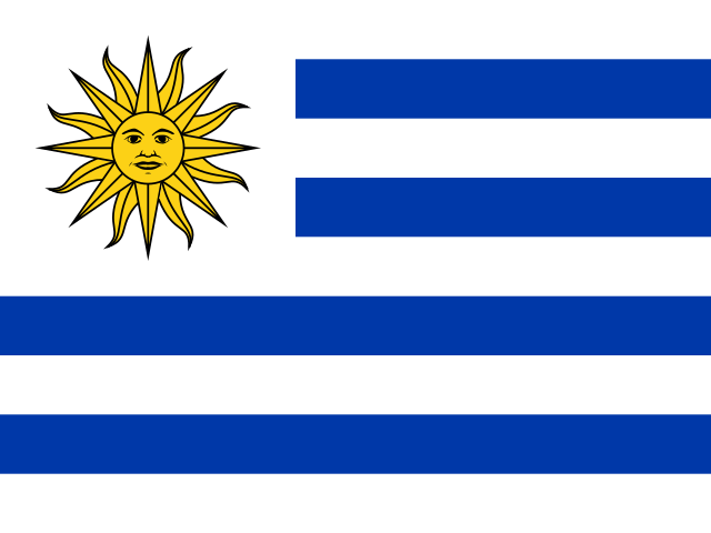
Nine equal horizontal stripes of white, with white at the top and bottom, alternate with blue; a white upper-left square contains a yellow Sun of May with a human face, black outline, and sixteen alternating triangular and wavy rays. The stripes represent the country's nine original departments; the sun refers to the legend of the sun breaking through clouds on 25 May 1810, when independence was declared from Spain. The Sun of May is said to be Inti, the Inca god of the sun.
Source: CIA World Factbook · 2026-02-01 · text generated from this source, approved by a person
 Uruguay