Field “Economy → GDP (official exchange rate)” in the CIA World Factbook archive (frozen 2026-02-01). Public domain. The Factbook stopped publishing in February 2026; the year shows when the value was estimated.
GDP per capita (PPP)
$5,800
Field “Economy → Real GDP per capita → Real GDP per capita 2023” in the CIA World Factbook archive (frozen 2026-02-01). Public domain. The Factbook stopped publishing in February 2026; the year shows when the value was estimated.
Each line is every country in this atlas that carries the value, ordered smallest to largest. The line down the middle is the world median; the mark on each line is this country.
median
Median age28.1 years152nd of 224 · median 32.6 years
Life expectancy69 years180th of 224 · median 76.2 years
Fertility rate2.76 children per woman53rd of 225 · median 1.92 children per woman
Population11,646224th of 235 · median 5,454,073
Total area26 km²225th of 228 · median 83,736 km²
Coastline24 km182nd of 229 · median 402 km
Overview
Name
"Tuvalu" means "group of eight" or "eight standing together" in the language, referring to eight of nine islands; Nui was excluded because its inhabitants spoke a different language. The former name honored Canadian shipping company owner Alexander Ellice, whose ship visited the islands in 1819.
Source: CIA World Factbook · 2026-02-01 · text generated from this source, approved by a person
Geography
An island group of coral atolls in the South Pacific Ocean, Tuvalu lies about halfway between Hawaii and Australia. The country consists of low-lying, narrow coral atolls. Nanumea, Nui, Vaitupu, Nukufetau, Funafuti, and Nukulaelae have lagoons open to the ocean.
Nanumaya and Niutao have landlocked lagoons, while Niulakita has no lagoon. Fish and coconut (copra) are natural resources. An unnamed location is the country's highest point. The Pacific Ocean is its lowest point.
Source: CIA World Factbook · 2026-02-01 · text generated from this source, approved by a person
Climate
Easterly trade winds moderate Tuvalu's tropical climate from March to November. From November to March, westerly gales bring heavy rain.
Source: CIA World Factbook · 2026-02-01 · text generated from this source, approved by a person
Flag and symbols
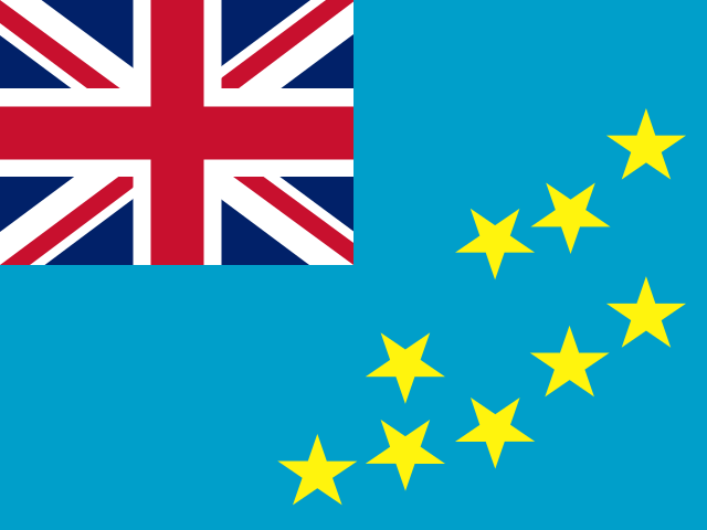
Light blue, the flag carries the UK flag in its upper-left quadrant and nine five-pointed yellow stars on its right half. The stars represent a map of the country, with each symbolizing an atoll in the ocean. The national symbol is the maneapa, a native meeting house.
Source: CIA World Factbook · 2026-02-01 · text generated from this source, approved by a person
Key figures
CIA World Factbook
Economy
GDP (nominal)
$62.28 million
Field “Economy → GDP (official exchange rate)” in the CIA World Factbook archive (frozen 2026-02-01). Public domain. The Factbook stopped publishing in February 2026; the year shows when the value was estimated.
GDP (PPP)
$57.06 million
Field “Economy → Real GDP (purchasing power parity) → Real GDP (purchasing power parity) 2023” in the CIA World Factbook archive (frozen 2026-02-01). Public domain. The Factbook stopped publishing in February 2026; the year shows when the value was estimated.
GDP per capita (PPP)
$5,800
Field “Economy → Real GDP per capita → Real GDP per capita 2023” in the CIA World Factbook archive (frozen 2026-02-01). Public domain. The Factbook stopped publishing in February 2026; the year shows when the value was estimated.
GDP growth
+3.9%
Field “Economy → Real GDP growth rate → Real GDP growth rate 2023” in the CIA World Factbook archive (frozen 2026-02-01). Public domain. The Factbook stopped publishing in February 2026; the year shows when the value was estimated.
Inflation (consumer prices)
11.5%
Field “Economy → Inflation rate (consumer prices) → Inflation rate (consumer prices) 2022” in the CIA World Factbook archive (frozen 2026-02-01). Public domain. The Factbook stopped publishing in February 2026; the year shows when the value was estimated.
Exports
$2.23 million
Field “Economy → Exports → Exports 2022” in the CIA World Factbook archive (frozen 2026-02-01). Public domain. The Factbook stopped publishing in February 2026; the year shows when the value was estimated.
Imports
$57.39 million
Field “Economy → Imports → Imports 2022” in the CIA World Factbook archive (frozen 2026-02-01). Public domain. The Factbook stopped publishing in February 2026; the year shows when the value was estimated.
People
Life expectancy
69 years
Field “People and Society → Life expectancy at birth → total population” in the CIA World Factbook archive (frozen 2026-02-01). Public domain. The Factbook stopped publishing in February 2026; the year shows when the value was estimated.
Median age
28.1 years
Field “People and Society → Median age → total” in the CIA World Factbook archive (frozen 2026-02-01). Public domain. The Factbook stopped publishing in February 2026; the year shows when the value was estimated.
Birth rate
21.57 per 1,000
Field “People and Society → Birth rate” in the CIA World Factbook archive (frozen 2026-02-01). Public domain. The Factbook stopped publishing in February 2026; the year shows when the value was estimated.
Death rate
7.78 per 1,000
Field “People and Society → Death rate” in the CIA World Factbook archive (frozen 2026-02-01). Public domain. The Factbook stopped publishing in February 2026; the year shows when the value was estimated.
Fertility rate
2.76 children per woman
Field “People and Society → Total fertility rate” in the CIA World Factbook archive (frozen 2026-02-01). Public domain. The Factbook stopped publishing in February 2026; the year shows when the value was estimated.
Population growth
+0.75% a year
Field “People and Society → Population growth rate” in the CIA World Factbook archive (frozen 2026-02-01). Public domain. The Factbook stopped publishing in February 2026; the year shows when the value was estimated.
Urban population
66.2%
Field “People and Society → Urbanization → urban population” in the CIA World Factbook archive (frozen 2026-02-01). Public domain. The Factbook stopped publishing in February 2026; the year shows when the value was estimated.
Literacy
100%
Field “People and Society → Literacy → total population” in the CIA World Factbook archive (frozen 2026-02-01). Public domain. The Factbook stopped publishing in February 2026; the year shows when the value was estimated.
Languages
Tuvaluanofficial
Englishofficial
Samoan
Kiribati
Field “People and Society → Languages” in the CIA World Factbook archive (frozen 2026-02-01). Public domain. The Factbook stopped publishing in February 2026; the year shows when the value was estimated.
Religions
Protestant92.7%Congregational Christian Church of Tuvalu 85.9%, Brethren 2.8%, Seventh Day Adventist 2.5%, Assemblies of God 1.5%
Baha'i1.5%
Jehovah's Witness1.5%
other0.4%
Field “People and Society → Religions” in the CIA World Factbook archive (frozen 2026-02-01). Public domain. The Factbook stopped publishing in February 2026; the year shows when the value was estimated.
Land
Total area
26 km²Land 26 km² · Water 0 km²
Field “Geography → Area → total” in the CIA World Factbook archive (frozen 2026-02-01). Public domain. The Factbook stopped publishing in February 2026; the year shows when the value was estimated.
Coastline
24 km
Field “Geography → Coastline” in the CIA World Factbook archive (frozen 2026-02-01). Public domain. The Factbook stopped publishing in February 2026; the year shows when the value was estimated.
Land borders
0 km
Field “Geography → Land boundaries → total” in the CIA World Factbook archive (frozen 2026-02-01). Public domain. The Factbook stopped publishing in February 2026; the year shows when the value was estimated.
Mean elevation
2 m
Field “Geography → Elevation → mean elevation” in the CIA World Factbook archive (frozen 2026-02-01). Public domain. The Factbook stopped publishing in February 2026; the year shows when the value was estimated.
Highest point
5 m unnamed location
Field “Geography → Elevation → highest point” in the CIA World Factbook archive (frozen 2026-02-01). Public domain. The Factbook stopped publishing in February 2026; the year shows when the value was estimated.
Values from the CIA World Factbook archive. Each carries the year it describes; open a year for the exact source field.
 Tuvalu