Overview
Name
The suffix "- ostan" means "land," making the country name mean "Land of the Tajik [people]." "Tajik" comes from the Sanskrit "tajika," a name originally used to distinguish Arabs from Turks and derived from the Tay, an Arab people.
Source: CIA World Factbook · 2026-02-01 · text generated from this source, approved by a person
Background
The Tajik people came under Russian imperial rule in the 1860s and 1870s; after the Revolution of 1917, basmachi guerrillas contested Bolshevik control until it was fully reestablished in 1925. Tajikistan became an autonomous Soviet Socialist Republic within the Uzbek Soviet Socialist Republic in 1924, then a separate republic in 1929. After independence in 1991, civil war among political, regional, and religious factions lasted from 1992 to 1997.
Emomali Rahmon came to power in 1992 during the civil war and was first elected president in 1994. Observers describe elections as neither free nor fair, citing irregularities and abuse. In 2015, Rahmon used an attack planned by a deputy defense minister to ban the last major opposition party. Amendments gave him the title "Founder of Peace and National Unity, Leader of the Nation," limitless terms, and lifelong immunity. In 2020, he orchestrated Rustam Emomali’s selection as upper-chamber chairman, positioning his son for succession. After joining the WTO in 2013, Tajikistan remained the poorest former Soviet republic, amid economic dependence on remittances, corruption, the opiate trade, and violence from Afghanistan. Since 2010, incidents included armed conflicts in Rasht Valley and Gorno-Badakhshan Autonomous Oblast, an ISIS-claimed attack in 2018 that killed Western bicyclists, and fatal clashes between border forces on the Kyrgyzstan border in 2021 and 2022.
Source: CIA World Factbook · 2026-02-01 · text generated from this source, approved by a person
Climate
Hot summers and mild winters mark Tajikistan's mid-latitude continental climate, while the Pamir Mountains range from semiarid to polar conditions.
Source: CIA World Factbook · 2026-02-01 · text generated from this source, approved by a person
Government
The government is a presidential republic. Its legal system is a civil law system. The latest constitution was adopted 6 November 1994, after several previous constitutions. Independence came on 9 September 1991, from the Soviet Union. The national holiday is Independence Day (or National Day), on 9 September (1991).
Source: CIA World Factbook · 2026-02-01 · text generated from this source, approved by a person
Flag and symbols
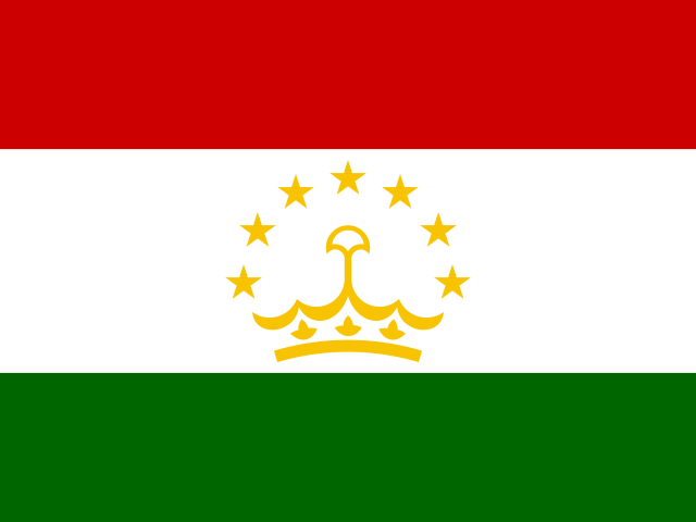
Three horizontal stripes—red at the top, a wider white stripe, and green—carry a gold crown beneath seven five-pointed gold stars in the white stripe’s center. Red stands for the sun, victory, and the unity of the nation; white for purity, cotton, and mountain snows; green for Islam and nature’s bounty. National symbols are an arc of seven five-pointed stars over a crown and Marco Polo sheep.
Source: CIA World Factbook · 2026-02-01 · text generated from this source, approved by a person
 Tajikistan