Overview
Name
A mistaken belief that the islands contained great riches led Spanish explorer Alvaro de Mendana to name them Solomon Islands in 1568, after the wealthy biblical King Solomon.
Source: CIA World Factbook · 2026-02-01 · text generated from this source, approved by a person
Background
Settlers from Papua and Austronesian settlers arrived on the Solomon Islands, and the two groups mixed extensively. Despite inter-island trade, no attempts united the islands politically. In 1568, a Spanish explorer first spotted the islands; a permanent settlement failed, and a British explorer arrived in 1767. Germany and the UK established northern and southern protectorates in 1885 and 1893, and Germany transferred its islands to the UK in 1899.
Japan invaded in 1942; the Guadalcanal Campaign, from August 1942 to February 1943, proved a turning point in the Pacific theater of WWII. Fighting destroyed large parts of the islands, and a nationalist movement emerged near the war’s end. The British allowed local autonomy by 1960; self-government came in 1976 and independence under Prime Minister Sir Peter Kenilorea. Civil war erupted between Guale in Honiara and Malaitans in Honiara’s suburbs in 1999, sending Malaitans to Honiara and Guale away. Sogavare’s 2000 peace agreements and equal resource distribution bankrupted the government in 2001; after a 2003 request, an Australian-led mission improved security until 2017. Sogavare was reelected in 2019; in 2021, police tear-gassed protestors petitioning for his removal, sparking rioting and looting in Honiara.
Source: CIA World Factbook · 2026-02-01 · text generated from this source, approved by a person
Geography
The Solomon Islands occupy a strategic location on sea routes between the South Pacific Ocean, the Solomon Sea, and the Coral Sea. The Solomon Islands are a group of islands in Oceania and the South Pacific Ocean, east of Papua New Guinea. The terrain is mostly rugged mountains, with some low coral atolls. Rennell Island, the southernmost in the Solomon Islands chain, is one of the world's largest raised coral atolls.
Lake Tegano, formerly a lagoon on the atoll, is the largest lake in the insular Pacific. Natural resources include fish, forests, gold, bauxite, phosphates, lead, zinc, and nickel. Mount Popomanaseu is the highest point. The Pacific Ocean is the lowest point.
Source: CIA World Factbook · 2026-02-01 · text generated from this source, approved by a person
Government
Under a constitutional monarchy, Solomon Islands has a parliamentary democracy and is a Commonwealth realm. Its legal system mixes English common law and customary law. Its constitution was adopted 31 May 1978 and took effect 7 July 1978. Independence from the UK came on 7 July 1978. The national holiday is Independence Day, 7 July (1978).
Source: CIA World Factbook · 2026-02-01 · text generated from this source, approved by a person
Flag and symbols
A yellow stripe divides the Solomon Islands flag diagonally from the lower-left corner, separating a blue upper triangle on the left from a green lower triangle. Five five-pointed white stars appear in an X pattern in the blue triangle and stand for the main island groups. Blue stands for the ocean, green for the land, and yellow for sunshine.
Source: CIA World Factbook · 2026-02-01 · text generated from this source, approved by a person
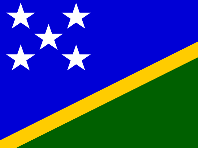 Solomon Islands