1 city

Location of São Tomé and PrincipeEquatorial GuineaGabonCameroonSão Tomé and PrincipeSão Tomé
Country

São Tomé and Principe

0.17° N, 6.59° E

No land border at all — every neighbor is across water, along 209 km of coast, the 136th longest on Earth.

land borders 0 km · 164th/230 · coastline 209 km · 136th/229
CIA World Factbook · 2026-02-01 · ranks computed across the countries in this atlas that carry the value

Population
215,056
Area
964 km²
Population density
≈ 219 / km²
Capital
São Tomé
Natural Earth
ISO codes
ST · STP
GDP (nominal)
$764.27 million
GDP per capita (PPP)
$5,500
How big, reallyDrawn at the same scale as Kiribati. Equal-area projection, not the map you are used to.
São Tomé and Principe 964 km²Kiribati 811 km²

geometry: Natural Earth 1:50m · EPSG:6933 equal-area

Where São Tomé and Principe sits in the world

Each line is every country in this atlas that carries the value, ordered smallest to largest. The line down the middle is the world median; the mark on each line is this country.

  1. Median age21.2 years191st of 224 · median 32.6 years
  2. Life expectancy67.7 years192nd of 224 · median 76.2 years
  3. Fertility rate3.18 children per woman43rd of 225 · median 1.92 children per woman
  4. Population215,056185th of 235 · median 5,454,073
  5. Total area964 km²180th of 228 · median 83,736 km²
  6. Coastline209 km136th of 229 · median 402 km

Overview

Name

Portuguese discoverers named Sao Tome after Saint Thomas the Apostle on 21 December 1470 (or 1471), the saint's feast day. Principe is a shortening of the original Portuguese name "Ilha do Principe" ("Isle of the Prince"), referring to Prince Alphonso of Portugal.

Source: CIA World Factbook · 2026-02-01 · text generated from this source, approved by a person

People and society

Mestico, Angolares, and Forros are among the islands' people; Angolares descend from Angolan slaves, while Forros descend from freed slaves. Servicais are contract laborers from Angola, Mozambique, and Cabo Verde, and Tongas are children of servicais born on the islands. Europeans, primarily Portuguese, and Asians, mostly Chinese, are also part of the population. Religions include Catholic, Adventist, Assembly of God, New Apostolic, Mana, Universal Kingdom of God, and Jehovah's Witness, alongside people reporting no religion or unspecified affiliations.

Sao Tome, the capital city, contains a share of the nation's population, while Santo Antonio is the largest town on Principe. The northern areas of both islands have the highest population densities.

Source: CIA World Factbook · 2026-02-01 · text generated from this source, approved by a person

Government

Government takes the form of a semi-presidential republic. Its legal system is a mixed system of civil law based on the Portuguese model and customary law. The constitution was approved 5 November 1975. Independence from Portugal came on 12 July 1975. Independence Day, 12 July (1975), is the national holiday.

Source: CIA World Factbook · 2026-02-01 · text generated from this source, approved by a person

Flag and symbols

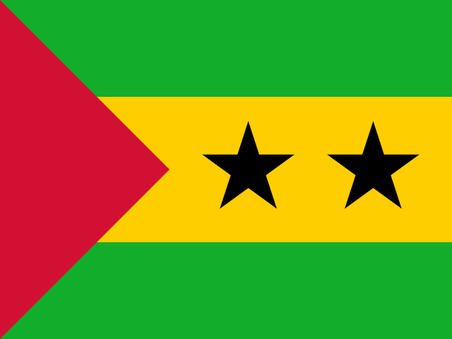
Three horizontal bands are green at the top, double-width yellow in the middle, and green at the bottom. The yellow band has two five-pointed black stars in its center and a red isosceles triangle based on the left side. The flag uses the colors of the Pan-African movement. Green stands for the country's rich vegetation, red for the struggle for independence, and yellow for cocoa, one of the country's main agricultural products. The two stars symbolize the main islands. A palm tree is the national symbol.

Source: CIA World Factbook · 2026-02-01 · text generated from this source, approved by a person
Key figures

CIA World Factbook

Economy

GDP (nominal)
$764.27 million
GDP (PPP)
$1.29 billion
GDP per capita (PPP)
$5,500
GDP growth
+0.9%
Inflation (consumer prices)
14.4%
Unemployment
9.2%
Exports
$96.98 million
Imports
$219.32 million

People

Life expectancy
67.7 years
Median age
21.2 years
Birth rate
25.87 per 1,000
Death rate
5.84 per 1,000
Fertility rate
3.18 children per woman
Population growth
+1.39% a year
Urban population
76.4%
Literacy
87.4%
Religions
  • Catholic55.7%
  • Adventist4.1%
  • Assembly of God3.4%
  • New Apostolic2.9%
  • Mana2.3%
  • Universal Kingdom of God2%
  • Jehovah's Witness1.2%
  • other1%

Land

Total area
964 km²Land 964 km² · Water 0 km²
Coastline
209 km
Land borders
0 km
Highest point
2,024 m Pico de Sao Tome

Values from the CIA World Factbook archive. Each carries the year it describes; open a year for the exact source field.

Connections

Natural geography 4

Natural Earth outlines · features with a Wikidata ID

Largest cities 1

Population · Natural Earth

  1. São Tomécapital88.2K

Sources