34 cities

Location of PhilippinesMyanmarMalaysiaPapua New GuineaPalauHong KongBruneiMacaoGuamIndonesiaNorthern Mariana IslandsVietnamLaosIndiaAustraliaThailandBhutanChinaSingaporeTimor-LesteJapanSouth KoreaBangladeshTaiwanCambodiaMicronesiaPhilippinesManilaZamboangaQuezon CityBacolodIliganDavaoCagayan de OroGeneral SantosCebuNaga
Country

Philippines

11.20° N, 122.47° E

No land border at all — every neighbor is across water, along 36,289 km of coast, the 5th longest on Earth.

land borders 0 km · 164th/230 · coastline 36,289 km · 5th/229
CIA World Factbook · 2026-02-01 · ranks computed across the countries in this atlas that carry the value

Population
108,116,615
Area
300,000 km²
Population density
≈ 374 / km²
Capital
Manila
Natural Earth
ISO codes
PH · PHL
GDP (nominal)
$461.62 billion
GDP per capita (PPP)
$10,400
How big, reallyDrawn at the same scale as Uganda. Equal-area projection, not the map you are used to.
Philippines 300,000 km²Uganda 241,038 km²

geometry: Natural Earth 1:50m · EPSG:6933 equal-area

Where Philippines sits in the world

Each line is every country in this atlas that carries the value, ordered smallest to largest. The line down the middle is the world median; the mark on each line is this country.

  1. Median age27.1 years159th of 224 · median 32.6 years
  2. Life expectancy70.8 years167th of 224 · median 76.2 years
  3. Fertility rate1.94 children per woman108th of 225 · median 1.92 children per woman
  4. Population108,116,61513th of 235 · median 5,454,073
  5. Total area300,000 km²73rd of 228 · median 83,736 km²
  6. Coastline36,289 km5th of 229 · median 402 km

Overview

Name

Spanish explorer Ruy Lopez de Villalobos, who visited the islands in 1543, named them in honor of King Phillip II of Spain.

Source: CIA World Factbook · 2026-02-01 · text generated from this source, approved by a person
Flag and symbols

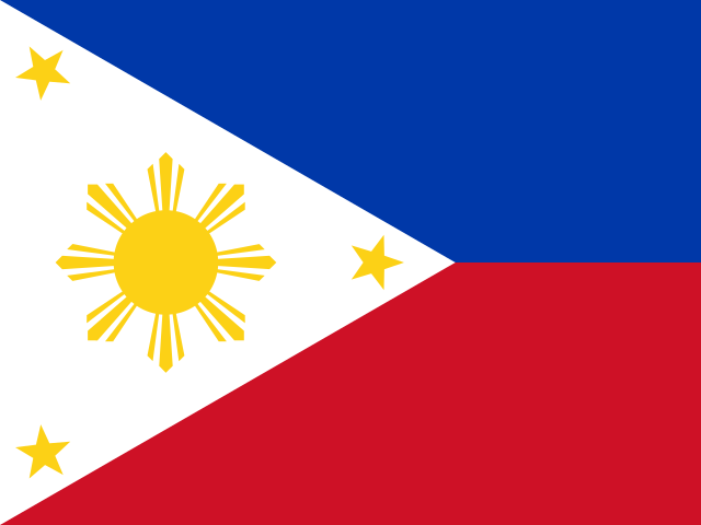
Two equal horizontal bands of blue and red form the flag, with blue above red. A white equilateral triangle based on the left side contains a yellow sun with eight rays and a five-pointed yellow star at each corner. Blue stands for peace and justice, red for courage, triangle for equality. The stars represent Luzon, Visayas, and Mindanao. National symbols are three stars and sun and Philippine eagle.

Source: CIA World Factbook · 2026-02-01 · text generated from this source, approved by a person

Key figures

CIA World Factbook

Economy

GDP (nominal)
$461.62 billion
GDP (PPP)
$1.2 trillion
GDP per capita (PPP)
$10,400
GDP growth
+5.7%
Inflation (consumer prices)
3.2%
Unemployment
2.2%
Exports
$106.99 billion
Imports
$161.15 billion

People

Life expectancy
70.8 years
Median age
27.1 years
Birth rate
16.02 per 1,000
Death rate
5.8 per 1,000
Fertility rate
1.94 children per woman
Population growth
+0.74% a year
Urban population
48.3%
Literacy
98.5%
Languages
  • Tagalog39.9%
  • Bisaya/Binisaya16%
  • Hiligaynon/Ilonggo7.3%
  • Ilocano7.1%
  • Cebuano6.5%
  • Bikol/Bicol3.9%
  • Waray2.6%
  • Kapampangan2.4%
  • Maguindanao1.4%
  • Pangasinan/Panggalato1.3%
  • others0.4%

Land

Total area
300,000 km²Land 298,170 km² · Water 1,830 km²
Coastline
36,289 km
Land borders
0 km
Mean elevation
442 m
Highest point
2,954 m Mount Apo

Values from the CIA World Factbook archive. Each carries the year it describes; open a year for the exact source field.

Connections

Natural geography 27

Natural Earth outlines · features with a Wikidata ID

Lakes 1

Largest cities 34

Population · Natural Earth

  1. Manilacapital11.1M
  2. Quezon City2.8M
  3. Davao1.4M
  4. Cagayan de Oro1.1M
  5. General Santos950.5K
  6. Bacolod949.4K
  7. Cebu815K
  8. Zamboanga773K
  9. Naga741.6K
  10. Iligan464.6K
  11. Baguiocapital447.8K
  12. Batangas424.5K

Sources