No coast at all — every one of its 4,655 km of border is shared with another country.
coastline 0 km · 185th/229 · land borders 4,655 km · 39th/230 CIA World Factbook · 2026-02-01 · ranks computed across the countries in this atlas that carry the value
Population
7,044,636
Natural Earth population estimate.
Area
406,752 km²
Official total area (land + water) from the CIA World Factbook. Computed from the Natural Earth boundary: ≈ 399,949 km².
Field “Economy → GDP (official exchange rate)” in the CIA World Factbook archive (frozen 2026-02-01). Public domain. The Factbook stopped publishing in February 2026; the year shows when the value was estimated.
GDP per capita (PPP)
$16,300
Field “Economy → Real GDP per capita → Real GDP per capita 2024” in the CIA World Factbook archive (frozen 2026-02-01). Public domain. The Factbook stopped publishing in February 2026; the year shows when the value was estimated.
Each line is every country in this atlas that carries the value, ordered smallest to largest. The line down the middle is the world median; the mark on each line is this country.
median
Median age32.3 years115th of 224 · median 32.6 years
Life expectancy78.8 years71st of 224 · median 76.2 years
Fertility rate1.88 children per woman117th of 225 · median 1.92 children per woman
Population7,044,636105th of 235 · median 5,454,073
Total area406,752 km²60th of 228 · median 83,736 km²
Coastline0 km185th of 229 · median 402 km
Overview
Climate
Subtropical to temperate conditions bring substantial rainfall to the eastern portions, while the far west becomes semiarid. Local flooding affects the southeast from early September to June, and poorly drained plains may become boggy from early October to June.
Source: CIA World Factbook · 2026-02-01 · text generated from this source, approved by a person
People and society
The country's people include Mestizo, meaning mixed Spanish and Indigenous ancestry, and other ethnic groups. Spanish and Guarani are official, and language use also includes only Guarani, only Spanish, Portuguese, German, and other Indigenous languages. Religious affiliations include Roman Catholic, Protestant, Believer (not belonging to the church), agnostic, and none; Protestant groups include Evangelical, Evangelical Pentecostal, Adventist, and Protestant (non-specific).
Most of the population resides in the eastern half of the country, while the Gran Chaco lies to the west. The Gran Chaco is a semi-arid lowland plain, and its share of the overall population is small.
Source: CIA World Factbook · 2026-02-01 · text generated from this source, approved by a person
Flag and symbols
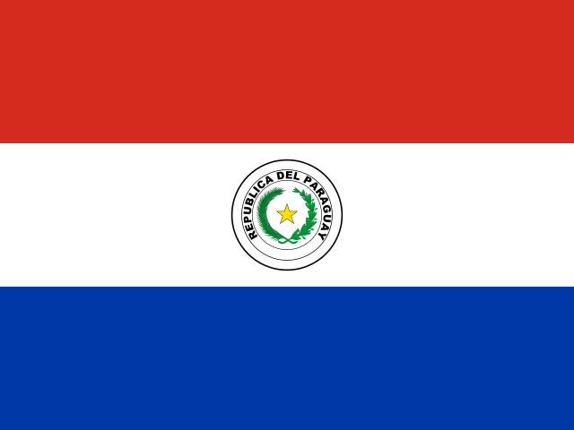
Three equal horizontal bands—red on top, followed by white and blue—carry an emblem centered on the white band. One side shows the national coat of arms: a five-pointed yellow star in a green wreath, with REPUBLICA DEL PARAGUAY around it inside two circles. The other side shows a circular treasury seal: a yellow lion below a red Cap of Liberty, with PAZ Y JUSTICIA. The national symbol is the lion.
Source: CIA World Factbook · 2026-02-01 · text generated from this source, approved by a person
Key figures
CIA World Factbook
Economy
GDP (nominal)
$44.46 billion
Field “Economy → GDP (official exchange rate)” in the CIA World Factbook archive (frozen 2026-02-01). Public domain. The Factbook stopped publishing in February 2026; the year shows when the value was estimated.
GDP (PPP)
$112.92 billion
Field “Economy → Real GDP (purchasing power parity) → Real GDP (purchasing power parity) 2024” in the CIA World Factbook archive (frozen 2026-02-01). Public domain. The Factbook stopped publishing in February 2026; the year shows when the value was estimated.
GDP per capita (PPP)
$16,300
Field “Economy → Real GDP per capita → Real GDP per capita 2024” in the CIA World Factbook archive (frozen 2026-02-01). Public domain. The Factbook stopped publishing in February 2026; the year shows when the value was estimated.
GDP growth
+4.2%
Field “Economy → Real GDP growth rate → Real GDP growth rate 2024” in the CIA World Factbook archive (frozen 2026-02-01). Public domain. The Factbook stopped publishing in February 2026; the year shows when the value was estimated.
Inflation (consumer prices)
3.8%
Field “Economy → Inflation rate (consumer prices) → Inflation rate (consumer prices) 2024” in the CIA World Factbook archive (frozen 2026-02-01). Public domain. The Factbook stopped publishing in February 2026; the year shows when the value was estimated.
Unemployment
6.1%
Field “Economy → Unemployment rate → Unemployment rate 2024” in the CIA World Factbook archive (frozen 2026-02-01). Public domain. The Factbook stopped publishing in February 2026; the year shows when the value was estimated.
Exports
$17.4 billion
Field “Economy → Exports → Exports 2024” in the CIA World Factbook archive (frozen 2026-02-01). Public domain. The Factbook stopped publishing in February 2026; the year shows when the value was estimated.
Imports
$18.38 billion
Field “Economy → Imports → Imports 2024” in the CIA World Factbook archive (frozen 2026-02-01). Public domain. The Factbook stopped publishing in February 2026; the year shows when the value was estimated.
People
Life expectancy
78.8 years
Field “People and Society → Life expectancy at birth → total population” in the CIA World Factbook archive (frozen 2026-02-01). Public domain. The Factbook stopped publishing in February 2026; the year shows when the value was estimated.
Median age
32.3 years
Field “People and Society → Median age → total” in the CIA World Factbook archive (frozen 2026-02-01). Public domain. The Factbook stopped publishing in February 2026; the year shows when the value was estimated.
Birth rate
15.66 per 1,000
Field “People and Society → Birth rate” in the CIA World Factbook archive (frozen 2026-02-01). Public domain. The Factbook stopped publishing in February 2026; the year shows when the value was estimated.
Death rate
4.97 per 1,000
Field “People and Society → Death rate” in the CIA World Factbook archive (frozen 2026-02-01). Public domain. The Factbook stopped publishing in February 2026; the year shows when the value was estimated.
Fertility rate
1.88 children per woman
Field “People and Society → Total fertility rate” in the CIA World Factbook archive (frozen 2026-02-01). Public domain. The Factbook stopped publishing in February 2026; the year shows when the value was estimated.
Population growth
+1.06% a year
Field “People and Society → Population growth rate” in the CIA World Factbook archive (frozen 2026-02-01). Public domain. The Factbook stopped publishing in February 2026; the year shows when the value was estimated.
Urban population
63.1%
Field “People and Society → Urbanization → urban population” in the CIA World Factbook archive (frozen 2026-02-01). Public domain. The Factbook stopped publishing in February 2026; the year shows when the value was estimated.
Literacy
94.9%
Field “People and Society → Literacy → total population” in the CIA World Factbook archive (frozen 2026-02-01). Public domain. The Factbook stopped publishing in February 2026; the year shows when the value was estimated.
Languages
Spanish and Guaraniofficial46.3%
only Guarani34%
only Spanish15.2%
no response0.4%
others4.1%
Field “People and Society → Languages → Languages” in the CIA World Factbook archive (frozen 2026-02-01). Public domain. The Factbook stopped publishing in February 2026; the year shows when the value was estimated.
Land
Total area
406,752 km²Land 397,302 km² · Water 9,450 km²
Field “Geography → Area → total” in the CIA World Factbook archive (frozen 2026-02-01). Public domain. The Factbook stopped publishing in February 2026; the year shows when the value was estimated.
Coastline
0 km
Field “Geography → Coastline” in the CIA World Factbook archive (frozen 2026-02-01). Public domain. The Factbook stopped publishing in February 2026; the year shows when the value was estimated.
Land borders
4,655 km
Field “Geography → Land boundaries → total” in the CIA World Factbook archive (frozen 2026-02-01). Public domain. The Factbook stopped publishing in February 2026; the year shows when the value was estimated.
Mean elevation
178 m
Field “Geography → Elevation → mean elevation” in the CIA World Factbook archive (frozen 2026-02-01). Public domain. The Factbook stopped publishing in February 2026; the year shows when the value was estimated.
Highest point
842 m Cerro Pero
Field “Geography → Elevation → highest point” in the CIA World Factbook archive (frozen 2026-02-01). Public domain. The Factbook stopped publishing in February 2026; the year shows when the value was estimated.
Values from the CIA World Factbook archive. Each carries the year it describes; open a year for the exact source field.
 Paraguay