Overview
Background
Austronesian settlers reached the islands around 1500 BCE, becoming the indigenous Chamorro; later migrations included Micronesians and island Southeast Asians. Ferdinand Magellan sailed through the Mariana Islands in 1521; Spain claimed them in 1565 and formally colonized them in 1668. Spain administered the archipelago from Guam and forced the Chamorro to resettle there amid repression and disease. Spain ceded Guam to the US in 1898 and sold the Northern Mariana Islands to Germany under the German-Spanish Treaty of 1899; Germany administered them from German New Guinea.
Following World War I, Japan administered the islands under a League of Nations mandate, focused on sugar and brought in Japanese laborers who quickly outnumbered the Chamorro. During World War II, Japan invaded Guam from the islands and used Marianan Chamorro as translators with Guamanian Chamorro, creating friction. The US captured the Northern Mariana Islands in 1944 after the Battle of Saipan and later administered them in the TTPI. In 1978, the islands gained self-governance separate from the TTPI; in 1986, they gained US citizenship and came under US sovereignty as the Commonwealth of the Northern Mariana Islands. In 2009, the Northern Mariana Islands became the final US territory to elect a nonvoting delegate to the US Congress.
Source: CIA World Factbook · 2026-02-01 · text generated from this source, approved by a person
Climate
Northeast trade winds moderate the tropical marine climate of the Northern Mariana Islands, keeping seasonal temperature variation slight. A dry season runs from December to June, followed by a rainy season from July to October.
Source: CIA World Factbook · 2026-02-01 · text generated from this source, approved by a person
Government
As a commonwealth in political union with and under the sovereignty of the US, the Northern Mariana Islands has a republican form of government with separate executive, legislative, and judicial branches. The laws of the US apply, except for customs and some aspects of taxation. The constitution was partially effective 9 January 1978 and fully effective 4 November 1986 (Covenant Agreement). The commonwealth has no independence, and its national holiday is Commonwealth Day, 8 January (1978).
Source: CIA World Factbook · 2026-02-01 · text generated from this source, approved by a person
Flag and symbols
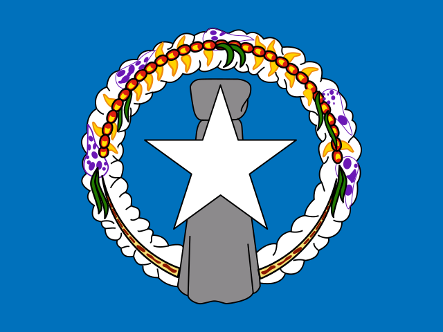
A five-pointed white star sits on a gray latte stone at the center of a blue flag, surrounded by a mwáár, or head lei. Blue stands for the Pacific Ocean, the star for the Commonwealth, and the latte stone and mwáár for Marianas culture. The mwáár is made from flores mayo, ylang-ylang or langilang, angagha or peacock flower, and teibwo or Pacific basil. The latte stone is the national symbol.
Source: CIA World Factbook · 2026-02-01 · text generated from this source, approved by a person
Natural geography 3
Natural Earth outlines · features with a Wikidata ID
 Northern Mariana Islands