7 cities

Location of MadagascarDemocratic Republic of the CongoeSwatiniKenyaUgandaAngolaFranceBurundiLesothoMauritiusSeychellesSouth AfricaComorosBotswanaMalawiSomaliaRwandaTanzaniaMozambiqueZambiaZimbabweNamibiaMadagascarAntsirananaMahajangaAntsirabeToamasinaFianarantsoaAntananarivoToliara
Country

Madagascar

18.63° S, 46.70° E

No land border at all — every neighbor is across water, along 4,828 km of coast, the 30th longest on Earth.

land borders 0 km · 164th/230 · coastline 4,828 km · 30th/229
CIA World Factbook · 2026-02-01 · ranks computed across the countries in this atlas that carry the value

Population
26,969,307
Area
587,041 km²
Population density
≈ 45 / km²
Capital
Antananarivo
Natural Earth
ISO codes
MG · MDG
GDP (nominal)
$17.42 billion
GDP per capita (PPP)
$1,700
How big, reallyDrawn at the same scale as Sweden. Equal-area projection, not the map you are used to.
Madagascar 587,041 km²Sweden 450,295 km²

geometry: Natural Earth 1:50m · EPSG:6933 equal-area

Where Madagascar sits in the world

Each line is every country in this atlas that carries the value, ordered smallest to largest. The line down the middle is the world median; the mark on each line is this country.

  1. Median age20.5 years196th of 224 · median 32.6 years
  2. Life expectancy68.8 years183rd of 224 · median 76.2 years
  3. Fertility rate3.47 children per woman36th of 225 · median 1.92 children per woman
  4. Population26,969,30751st of 235 · median 5,454,073
  5. Total area587,041 km²48th of 228 · median 83,736 km²
  6. Coastline4,828 km30th of 229 · median 402 km

Overview

Name

The name began as a variant first used in the 13th century by Venetian explorer Marco Polo, who confused the island with Somalia's port of Mogadishu. The transliteration was later adopted as the official name.

Source: CIA World Factbook · 2026-02-01 · text generated from this source, approved by a person

Geography

An island in the Indian Ocean, Madagascar lies in Southern Africa, east of Mozambique. Along the Mozambique Channel, Madagascar lies close to the African continent, but ocean currents isolate the island. That isolation results in high rates of endemic plant and animal species.

Its terrain includes a narrow coastal plain, a high plateau, and mountains in the center. Madagascar's natural resources include graphite, chromite, coal, bauxite, rare earth elements, salt, quartz, tar sands, semiprecious stones, mica, fish, and hydropower. Maromokotro forms the island's highest point. The Indian Ocean marks its lowest point.

Source: CIA World Factbook · 2026-02-01 · text generated from this source, approved by a person

Climate

Along the coast, the climate is tropical; inland, it is temperate, while the south is arid.

Source: CIA World Factbook · 2026-02-01 · text generated from this source, approved by a person

Government

Its government is a semi-presidential republic. The legal system is a civil law system based on the old French civil code and customary law in matters of marriage, family, and obligation. The current constitution was passed by referendum 17 November 2010 and promulgated 11 December 2010. Independence from France came on 26 June 1960. Its national holiday is Independence Day, 26 June (1960).

Source: CIA World Factbook · 2026-02-01 · text generated from this source, approved by a person

Flag and symbols

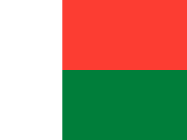
The flag has two equal horizontal bands, red on top and green below, with a vertical white band on the left side. Red stands for sovereignty, green for hope, and white for purity. The national symbols are the traveller's palm (ravenala) and zebu.

Source: CIA World Factbook · 2026-02-01 · text generated from this source, approved by a person
Key figures

CIA World Factbook

Economy

GDP (nominal)
$17.42 billion
GDP (PPP)
$52.97 billion
GDP per capita (PPP)
$1,700
GDP growth
+4.2%
Inflation (consumer prices)
9.9%
Unemployment
3.1%
Exports
$4.69 billion
Imports
$6.04 billion

People

Life expectancy
68.8 years
Median age
20.5 years
Birth rate
27.54 per 1,000
Death rate
5.95 per 1,000
Fertility rate
3.47 children per woman
Population growth
+2.15% a year
Urban population
40.6%
Literacy
74.7%
Religions
  • Church of Jesus Christ in Madagascar/Malagasy Lutheran Church/Anglican Church34%
  • Roman Catholic32.3%
  • traditional/Animist1.7%
  • Muslim1.4%
  • other21.9%

Land

Total area
587,041 km²Land 581,540 km² · Water 5,501 km²
Coastline
4,828 km
Land borders
0 km
Mean elevation
615 m
Highest point
2,876 m Maromokotro

Values from the CIA World Factbook archive. Each carries the year it describes; open a year for the exact source field.

Connections

Natural geography 5

Natural Earth outlines · features with a Wikidata ID

Oceans 1

Islands 1

Largest cities 7

Population · Natural Earth

  1. Antananarivocapital1.7M
  2. Antsirabe307.9K
  3. Toamasina210.2K
  4. Fianarantsoa184.2K
  5. Mahajanga154.7K
  6. Toliara115.3K
  7. Antsiranana82.9K

Sources