For every 16.73 per 1,000 births there are 6.23 per 1,000 deaths — the population is falling 0.77% a year.
population growth -0.77% · 220th/230 · birth rate 16.73 per 1,000 · 89th/226 · death rate 6.23 per 1,000 · 142nd/226 CIA World Factbook · 2026-02-01 · ranks computed across the countries in this atlas that carry the value
Population
6,855,713
Natural Earth population estimate.
Area
10,400 km²
Official total area (land + water) from the CIA World Factbook. Computed from the Natural Earth boundary: ≈ 10,009 km².
Field “Economy → GDP (official exchange rate)” in the CIA World Factbook archive (frozen 2026-02-01). Public domain. The Factbook stopped publishing in February 2026; the year shows when the value was estimated.
GDP per capita (PPP)
$11,300
Field “Economy → Real GDP per capita → Real GDP per capita 2023” in the CIA World Factbook archive (frozen 2026-02-01). Public domain. The Factbook stopped publishing in February 2026; the year shows when the value was estimated.
Each line is every country in this atlas that carries the value, ordered smallest to largest. The line down the middle is the world median; the mark on each line is this country.
median
Median age29.4 years140th of 224 · median 32.6 years
Life expectancy79.2 years65th of 224 · median 76.2 years
Fertility rate2.2 children per woman80th of 225 · median 1.92 children per woman
Population6,855,713108th of 235 · median 5,454,073
Total area10,400 km²167th of 228 · median 83,736 km²
Coastline225 km134th of 229 · median 402 km
Overview
Geography
Between Palestine and Syria, Lebanon borders the Mediterranean Sea in the Middle East. The terrain includes a narrow coastal plain; El Beqaa (Bekaa Valley) separates Lebanon and Anti-Lebanon Mountains. Qornet es Saouda is the highest point.
Limestone, iron ore, salt, water, and arable land are Lebanon's natural resources; Lebanon is a water-surplus state in a water-deficit region. Lebanon is the smallest country in continental Asia, and Nahr el Litani is the only major river in the Near East that does not cross an international boundary. The Mediterranean Sea is Lebanon's lowest point.
Source: CIA World Factbook · 2026-02-01 · text generated from this source, approved by a person
Government
Its government is a parliamentary democratic republic. The legal system is a mixed system of civil law based on the French civil code and Ottoman legal tradition, with religious laws covering personal status, marriage, divorce, and other family relations of the Jewish, Islamic, and Christian communities. The constitution was drafted 15 May 1926 and adopted 23 May 1926. Independence came on 22 November 1943 from League of Nations mandate under French administration. The national holiday is Independence Day, 22 November (1943).
Source: CIA World Factbook · 2026-02-01 · text generated from this source, approved by a person
Flag and symbols
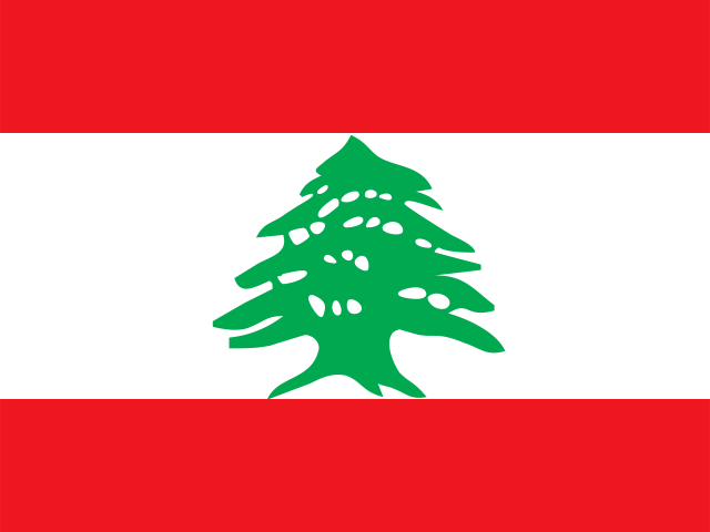
Three horizontal bands—red at the top and bottom, and a double-width white band between them—carry a green cedar tree centered on the white band. Red stands for blood shed for liberation, while white represents peace, the snow of the mountains, and purity. The green cedar tree, the national symbol, represents eternity, steadiness, happiness, and prosperity.
Source: CIA World Factbook · 2026-02-01 · text generated from this source, approved by a person
Key figures
CIA World Factbook
Economy
GDP (nominal)
$20.08 billion
Field “Economy → GDP (official exchange rate)” in the CIA World Factbook archive (frozen 2026-02-01). Public domain. The Factbook stopped publishing in February 2026; the year shows when the value was estimated.
GDP (PPP)
$65.42 billion
Field “Economy → Real GDP (purchasing power parity) → Real GDP (purchasing power parity) 2023” in the CIA World Factbook archive (frozen 2026-02-01). Public domain. The Factbook stopped publishing in February 2026; the year shows when the value was estimated.
GDP per capita (PPP)
$11,300
Field “Economy → Real GDP per capita → Real GDP per capita 2023” in the CIA World Factbook archive (frozen 2026-02-01). Public domain. The Factbook stopped publishing in February 2026; the year shows when the value was estimated.
GDP growth
-0.8%
Field “Economy → Real GDP growth rate → Real GDP growth rate 2023” in the CIA World Factbook archive (frozen 2026-02-01). Public domain. The Factbook stopped publishing in February 2026; the year shows when the value was estimated.
Inflation (consumer prices)
45.2%
Field “Economy → Inflation rate (consumer prices) → Inflation rate (consumer prices) 2024” in the CIA World Factbook archive (frozen 2026-02-01). Public domain. The Factbook stopped publishing in February 2026; the year shows when the value was estimated.
Unemployment
11.6%
Field “Economy → Unemployment rate → Unemployment rate 2023” in the CIA World Factbook archive (frozen 2026-02-01). Public domain. The Factbook stopped publishing in February 2026; the year shows when the value was estimated.
Exports
$11.77 billion
Field “Economy → Exports → Exports 2023” in the CIA World Factbook archive (frozen 2026-02-01). Public domain. The Factbook stopped publishing in February 2026; the year shows when the value was estimated.
Imports
$23.31 billion
Field “Economy → Imports → Imports 2023” in the CIA World Factbook archive (frozen 2026-02-01). Public domain. The Factbook stopped publishing in February 2026; the year shows when the value was estimated.
People
Life expectancy
79.2 years
Field “People and Society → Life expectancy at birth → total population” in the CIA World Factbook archive (frozen 2026-02-01). Public domain. The Factbook stopped publishing in February 2026; the year shows when the value was estimated.
Median age
29.4 years
Field “People and Society → Median age → total” in the CIA World Factbook archive (frozen 2026-02-01). Public domain. The Factbook stopped publishing in February 2026; the year shows when the value was estimated.
Birth rate
16.73 per 1,000
Field “People and Society → Birth rate” in the CIA World Factbook archive (frozen 2026-02-01). Public domain. The Factbook stopped publishing in February 2026; the year shows when the value was estimated.
Death rate
6.23 per 1,000
Field “People and Society → Death rate” in the CIA World Factbook archive (frozen 2026-02-01). Public domain. The Factbook stopped publishing in February 2026; the year shows when the value was estimated.
Fertility rate
2.2 children per woman
Field “People and Society → Total fertility rate” in the CIA World Factbook archive (frozen 2026-02-01). Public domain. The Factbook stopped publishing in February 2026; the year shows when the value was estimated.
Population growth
-0.77% a year
Field “People and Society → Population growth rate” in the CIA World Factbook archive (frozen 2026-02-01). Public domain. The Factbook stopped publishing in February 2026; the year shows when the value was estimated.
Urban population
89.4%
Field “People and Society → Urbanization → urban population” in the CIA World Factbook archive (frozen 2026-02-01). Public domain. The Factbook stopped publishing in February 2026; the year shows when the value was estimated.
Literacy
92%
Field “People and Society → Literacy → total population” in the CIA World Factbook archive (frozen 2026-02-01). Public domain. The Factbook stopped publishing in February 2026; the year shows when the value was estimated.
Languages
Arabicofficial
French
English
Armenian
Field “People and Society → Languages → Languages” in the CIA World Factbook archive (frozen 2026-02-01). Public domain. The Factbook stopped publishing in February 2026; the year shows when the value was estimated.
Land
Total area
10,400 km²Land 10,230 km² · Water 170 km²
Field “Geography → Area → total” in the CIA World Factbook archive (frozen 2026-02-01). Public domain. The Factbook stopped publishing in February 2026; the year shows when the value was estimated.
Coastline
225 km
Field “Geography → Coastline” in the CIA World Factbook archive (frozen 2026-02-01). Public domain. The Factbook stopped publishing in February 2026; the year shows when the value was estimated.
Land borders
484 km
Field “Geography → Land boundaries → total” in the CIA World Factbook archive (frozen 2026-02-01). Public domain. The Factbook stopped publishing in February 2026; the year shows when the value was estimated.
Mean elevation
1,250 m
Field “Geography → Elevation → mean elevation” in the CIA World Factbook archive (frozen 2026-02-01). Public domain. The Factbook stopped publishing in February 2026; the year shows when the value was estimated.
Highest point
3,088 m Qornet es Saouda
Field “Geography → Elevation → highest point” in the CIA World Factbook archive (frozen 2026-02-01). Public domain. The Factbook stopped publishing in February 2026; the year shows when the value was estimated.
Values from the CIA World Factbook archive. Each carries the year it describes; open a year for the exact source field.
 Lebanon