Name
The name derives from the Arabic "al qamar," meaning "the moon".
Source: CIA World Factbook · 2026-02-01 · text generated from this source, approved by a person
 Comoros
11.73° S, 43.32° E
No land border at all — every neighbor is across water, along 340 km of coast, the 126th longest on Earth.
land borders 0 km · 164th/230 · coastline 340 km · 126th/229
CIA World Factbook · 2026-02-01 · ranks computed across the countries in this atlas that carry the value
geometry: Natural Earth 1:50m · EPSG:6933 equal-area
Each line is every country in this atlas that carries the value, ordered smallest to largest. The line down the middle is the world median; the mark on each line is this country.
The name derives from the Arabic "al qamar," meaning "the moon".
Source: CIA World Factbook · 2026-02-01 · text generated from this source, approved by a person
A tropical marine climate brings a rainy season from November to May. During the rainy season, cyclones are possible from December to April.
Source: CIA World Factbook · 2026-02-01 · text generated from this source, approved by a person
Its ethnic groups are Antalote, Cafre, Makoa, Oimatsaha, and Sakalava. Muslims are overwhelmingly Sunni, with small Shia Muslim and Ahmadiyya Muslim populations; ethnic religionists and Christians are also present.
Maroni, on the western side of Grande Comore, is the capital city and the country's largest city. Anjouan is the most densely populated of the islands that comprise Comoros.
Source: CIA World Factbook · 2026-02-01 · text generated from this source, approved by a person
A federal presidential republic governs Comoros. Its legal system is a mixed system of Islamic religious law, the French civil code of 1975, and customary law. The newest constitution was adopted 30 July 2018. Comoros gained independence from France on 6 July 1975, and its national holiday is Independence Day, 6 July (1975).
Source: CIA World Factbook · 2026-02-01 · text generated from this source, approved by a person
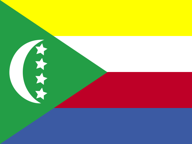
Yellow, white, red, and blue form four equal horizontal bands, with a green isosceles triangle based on the left. A vertical white crescent moon centers the triangle, with four five-pointed white stars in a line between its points. The bands and stars represent the four main islands: Mwali, N'gazidja, Ndzuwani, and Mahore. The national symbols are four five-pointed stars and a crescent moon.
Source: CIA World Factbook · 2026-02-01 · text generated from this source, approved by a person
CIA World Factbook
Values from the CIA World Factbook archive. Each carries the year it describes; open a year for the exact source field.
Natural Earth outlines · features with a Wikidata ID
Population · Natural Earth